- Morningthorpe
-
Coordinates: 52°30′14″N 1°17′45″E / 52.50389°N 1.2957°E
Morningthorpe 
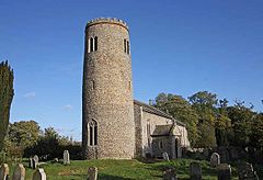
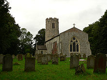
St John the Baptist, MorningthorpeMorningthorpe has a round tower rather larger than that at neighbouring Long Stratton: the tower appears to bulge out about halfway up, which, according to the article in Round Tower magazine September 2004, may be evidence of an octagonal tower built inside a round one. The article has photographs of repair work done to the tower in 1988 - one shows a corner of an "octagon" inner tower core, not bonded to the outside, while another suggests a bonded, and rounded, core. There are narrow openings in the tower with monolithic heads in worn pale stone, the openings filled with old-looking wooden boards pierced with vertical rows of round holes. Taylor & Taylor, Anglo-Saxon Architecture seek to assign this tower to the later Saxon period (or earlier Norman).
 Morningthorpe shown within Norfolk
Area 7.74 km2 (2.99 sq mi) Population 253 - Density 33 /km2 (85 /sq mi) OS grid reference TM 237 946 Parish Morningthorpe District South Norfolk Shire county Norfolk Region East Country England Sovereign state United Kingdom Post town NORWICH Postcode district NR15 Police Norfolk Fire Norfolk Ambulance East of England EU Parliament East of England List of places: UK • England • Norfolk Morningthorpe is a village and civil parish in the English county of Norfolk. It is situated some 20 kilometres (12 mi) south of the city of Norwich. Besides the village of Morningthorpe itself, the parish also includes the village of Fritton. The two villages are 1 km apart.[1]
The civil parish has an area of 7.74 square kilometres (2.99 sq mi) and in the 2001 census had a population of 253 in 94 households. For the purposes of local government, the parish falls within the district of South Norfolk.[2]
The churches of Morningthorpe St John the Baptist and Fritton St Catherine are two of 124 existing round-tower churches in Norfolk.
References
- ^ Ordnance Survey (1999). OS Explorer Map 237 - Norwich. ISBN 0-319-21868-6.
- ^ Office for National Statistics & Norfolk County Council (2001). Census population and household counts for unparished urban areas and all parishes. Retrieved December 2, 2005.
- ^ Morningthorpe parish information South Norfolk Council
External links
- Map sources for Morningthorpe village
- Map sources for Fritton village
- Information from Genuki Norfolk on Morningthorpe.
- Information from Genuki Norfolk on Fritton.
- Website with photos of Morningthorpe St John the Baptist,
- and Fritton St Catherine, two round tower churches
Categories:- South Norfolk
- Villages in Norfolk
- Civil parishes in Norfolk
- Norfolk geography stubs
- United Kingdom church stubs
Wikimedia Foundation. 2010.


