- Mogadouro Municipality
-
Mogadouro Municipality (Concelho)  Flag
Flag Coat of arms
Official name: Concelho de Mogadouro Country  Portugal
Region Norte Subregion Alto Trás-os-Montes District Bragança Municipality Mogadouro Center Mogadouro - elevation 790 m (2,592 ft) - coordinates 41°19′49″N 6°40′10″W / 41.33028°N 6.66944°W Highest point - location Cimos de Mogadouro, Mogadouro - elevation 900 m (2,953 ft) Length 40.32 km (25 mi), Southwest-Northeast Width 29.51 km (18 mi), Northwest-Southeast Area 760.65 km2 (294 sq mi) Population 10,792 (2001) Density 14.19 / km2 (37 / sq mi) LAU Concelho/Câmara Municipal - location Largo do Convento de São Francisco, Mogadouro, Mogadouro - elevation 725 m (2,379 ft) - coordinates 41°20′25″N 6°42′58″W / 41.34028°N 6.71611°W President António G. S. Moraes Machado (PPD-PSD) Municipal Chair Ilidio Granjo Vaz (PPD-PSD) Timezone WET (UTC0) - summer (DST) WEST (UTC+1) ISO 3166-2 code PT- Postal Zone 5200-244 Mogadouro Area Code & Prefix (+351) 279 XXX XXX Demonym Mogadourense Patron Saint São Mamede Municipal Address Largo do Convento de São Francisco
5200-244 MogadouroMunicipal Holidays 15 October 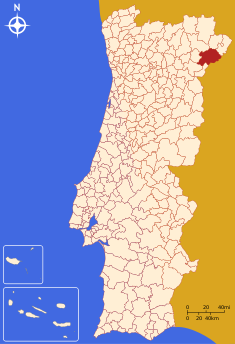 Location of the municipality of Mogadouro in continental Portugal
Wikimedia Commons: Mogadouro Website: http://www.mogadouro.pt/ Statistics from INE (2004); geographic detail from Instituto Geográfico Português (2010) Mogadouro (Portuguese: [muɣɐˈðowɾu], Mirandese: [muɣɐˈðawɾu]) is a municipality in Portugal with a total area of 760.65 km² and a total population of 10,792 inhabitants. The seat is the town of Mogadouro.
Contents
History
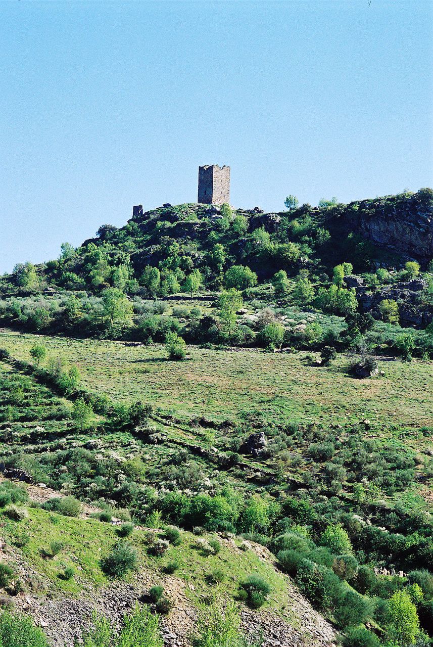
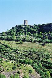 Built through the initiative of the templar knight Gualdim Pais
The history of Mogadouro is evidant in the number of castros that dot the landscape of region from the neolithic period.[1] In particular are the castros of Oleiros in Bemposta, Vilarinho, São Martinho do Peso, Figueirinha de Travanca, Bruçó and the more recently excavated castro in Vilariça, in the Serra da Castanheira.[1]
The Celts passed through this region, leaving behind its art and religion, the so called Cultura aos Berrões.[1] One of these celtic tribes, the Zoelae, were responsible for settling many of the lands along the Douro, Sabor and Angueira Rivers.[1]
During the Roman period, the region is referred to in art, religion and socio-economic reports, indicating its regional importance.[1] The Ara Romana to Deus Jupiter Depulsori (which still survives to this day in Saldanha), is one of these remnants of this period (it was constructed during the reign of Septimius Severus in the 3rd Century B.C.). Throughout the municipality that are have been discovered many funerary stones and artefacts that attest the Romanization of these lands.[1]
Vestiges of the Visigothic era are rare, but include a paleo-Christian inscription that was discovered in São Martinho do Peso (now in the Abade de Baçal Museum in Bragança.[1]
Moorish influence in this region is limited to local handicrafts made from flax and wool, that includes the hand embroidery, quilts, rugs and towels.[1] During the Reconquista era, it is known that Alfonso III of León effected many construction projects during his reign, that were more strategic then political: organizing a military line along the Douro with castles (to protect the holdings of the León while inducing incursions into Moorish lands, populating conquered territory and taking advantage of natural geography to defend his territory. After fortifying Zamora, around 893, he ordered the construction of castles along the line, repopulating them as he progressed. Toro and Simancas developed consequently from this policy. It is likely that the area of Mogadouro was settled as a strategic point along the line, resulting in the construction of the first fort. The regions name evolved from this settlement: Mógo means a implanted marker, considered a symbolic delineation of the separation or division of a territory, a term imported from common language at the time. The mógo do Douro (mark on the Douro), or Mogadouro, developed from this locational designation.
The Castle of Penas Róias was constructed during the nation-building of Afonso Henriques. The stone of the cell-block tower is inscribed with a medieval statement: "Começaram os fundamentos do Castelo chamadao Pena Roia na era de 1204 sendo Mestre Geral dos Templários Gualdim Pais" [They began the fundamentals of the Castle Pena Roia in the era of 1204 by Master General of the Templar Gualdim Pais].[1] The later Castle of Modagouro, from the same decade, was started prior to the establishment of the civic charter (foral) in 1272/73. During the Portuguese dynastic crisis (or Interregnum) the noble classes supported the King of Castile, resulting in an eventual reprisal by Prince John (who elevated the hamlet of Azinhoso and parsed it from Mogadouro).[1] Consequently, although it's economic activity did not contract, the lack of royal patronage meant that Mogadouro remained stagnated until the 16th century.[1]
Mogadouro, historically, fell within the Caminhos de Santiago, a capillary of secondary roadways that extended throughout the Trás-os-Montes region leading pilgrims down Saint James Way. The principal road arrived in Mogadouro from Castelo Rodrigo, from two routes: from Freixo de Espada à Cinta (Castelo Rodrigo, Figueira de Castelo Rodrigo, Escalhão, crossing the Douro by boat in Barca de Alva, Quinta de Santiago, Freixo de Espada à Cinta, Mós, Fornos, Lagoaça, Bruçó, Mogadouro); the other from Moncorvo (Castelo Rodrigo, Figueira de Castelo Rodrigo, Almendra, Castelo Melhor, Vila Nova de Foz Côa, crossing the Douro by boat in Pocinho, Moncorvo, Vilariça, Adeganha, Parada, here crossing the Sabor in Santo Antão da Barca before reaching Mogadouro). The Caminho de Santiago forked in Mogadouro at the Chapel of Nossa Senhora do Caminho (Caminho de Santigao): to Azinhoso (a enormous enclosure existed near the Church of Azinhoso to provide shelter during the crossing), then over a medieval bridge that connected Penas Roias, Algoso, Vimioso to Bragança; the other road departed from the Church of Nossa Senhora do Caminho, to Santiago, then Algosinho (to another pilgrimage church), Ventoselo (where there still remains vestiges of the pilgrimages, such as the roof painting in the Chapel of Nossa Senhor da Boa Morte), on the way passing by a spring (where pilgrimages would satisfy their thurst), to another chapel to Santigao (now completely destroyed), Urrós, Sendim, and Miranda do Douro). There were several tributaries, shortcuts and dirt tracks on the pilgram roadways, such as: through Azinhoso (where the faithful would rest in the chapel to São Gonçalo, a patron saint of the travellers); through Variz, Castanheira, Valcerto, Algoso, Campo de Víboras and Vimioso; through Santiago (now Vila de Ala), an important crossroads between Peredo de Bemposta (through Algosinho, Ventoselo and Vila de Ala) and Bemposta (through Lamoso, Tó and Vila de Ala). Those who travelled from the southern part of the district would likely stop in Zava (where a chapel to São Cristóvão, the saint protector, was located).
It was after the 16th century that Mogadouro saw some growth. The Távora family, a noble house with influence and power in court, controlled the region, commanding the fort and guiding the town, generally contributing to the development of the lands within their domain.[1] It was through the action of the Távoras that the local Santa Casa da Misericórdia was founded in 1559, and its local church. The bridges between Valverde and Meirinhos (in 1677), and the Remondes bridge, between Mogadouro and Macedo de Cavaleiros (in 1678) were also constructed with the patronage of the Távoras. In addition, the family supported the constructions of a few churches and altars in various municipalities throughout the 17th-18th century, including the Convent of São Francisco, the Matriz Church of Mogadouro, the Chapel of Nossa Senhora da Ascensão, in the heights of Serra da Castanheira and many others. But, by act of King Joseph I the Távoras lands were confiscated by the Marquess of Pombal, and members of the family executed after an attempted-assassination of the monarch. The annilhation of the family resulted in the loss of development impetus.[1]
The municipal archive, installed in the Convent of São Francisco (today the Mogadouro Municipal Chamber) burned down in 1881 (and again later in 1927).
After the extinction of the monastic orders, by the Liberal government, the Convent of São Francisco was appropriated to store public records and local administration.
By the 19th century, few of the noble families were interested in their holdings in Mogadouro, nor did they do much to develop these lands.[1] By the end of the century, only the poet-jurist José Francisco Trindade Coelho defended his land rights, and the region was abandoned by the central hiearchy of Lisbon.[1]
Geography
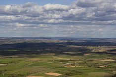 The Mirandês plateau region of Mogadouro, who to several species of hare, rabbit and partridge
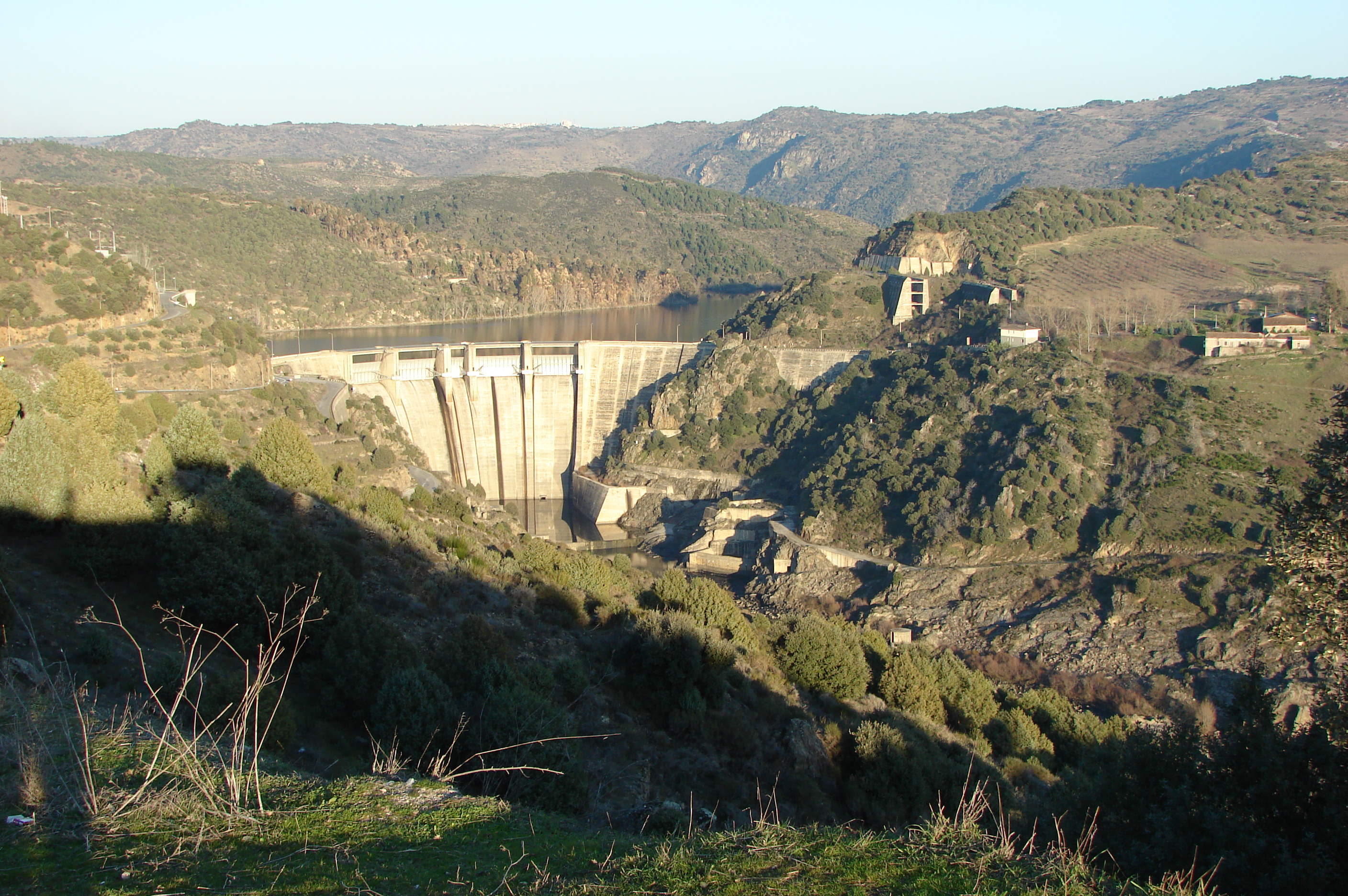
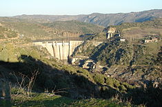 The Bemposta Dam in the heart of the Douro region of Mogadouro
Physical geography
The municipality of Mogadouro, situated in the Trás-os-Montes region of northeastern Portugal, in the traditional district of Bragança. It is boxed by the northeastern municipalities of Vimioso, Macedo de Cavaleiros, Alfândega da Fé, Torre de Moncorvo and Freixo de Espada à Cinta. It is separated from the Spanish province of Castilla y León, by a the river-valley of the Douro River, whose margins are cut by v-shaped inclines. The territory of Mogadouro is naturally delimited by environment of the Rivers Douro and Sabor. A great part of the territory of the Mogadouro belongs to the Mirandês Plateau (which is an extension of the Iberian Meseta), lands rich fertile fields responsible for the cultivation of cereals (such as wheat, oats, and rye), supporting cattle and sheep herds (including the Mirandese and Terra Quente breeds). Two sheltered valleys, with micro-climates, support vineyards, olive, orange and almond orchards, as well as other Mediterranean products.
The area around the Douro is a zone of granite escarpments of large blocks, resulting in a relief that is shaped by schists interrupted by quartz rocks that form the mountains. In the southern part of this area, dominated by the Sabor basin, there are different layers of shists. The soils, and climatic characteristics, have resulted in a diversified coverage that change throughout the year. Average median altitudes reach 700 metres, above sea level, although there are exceptions, as is the case with the Cimos de Mogadouro (usually around 900 m).
Ecoregions/Protected areas
Mogadouro is also the seat for the Parque Natural do Douro Internacional (International Douro Natural Park), a protected wilderness that includes primarily the slopes of the Douro valley, but also lands designated as bird sanctuaries for species of eagle (specifically the Bonelli and Golden Eagles), the Griffon and Egyptian vultures, and the rare Black Stork, in addition to the Red-billed Chough, the Alpine Swift and the Black Wheatear.
During the months of April and May, the flowering trees highlight the landscapes of many of the parishes. Mountain perennials (such as rosemary, Cytisus striatus and heather) are also common, although the Fagaceae (a species of beech) and holly oak, cork oak and Juniper (which grow along the slopes of the Douro and Sabor valleys) are the predominant species.
Climate
Located in the southern part of the Mirandês Plateau, the region is influenced by three climatic systems: the Atlantic, the Continent and the Mediterranean. As a result, its agriculture is varied and its landscape is full of contrasts. In the winter, the climate is rigorously cold and icy, with snowfall common throughout the period. In the summer, its is susceptible to torrid heat, typical of continental climates, that supports a dry vegetation.
Human geography
The municipality of Mogadouro has, over the last decades, suffered an enormous depopulation, resulting in the concentration into the urbanized areas, and emigration to the coastal communities of Portugal. Like many of the Transmontana communities, Mogadouran hamlets built on traditional homes adapted to the climate of the region, built of granite or schist material, with verandas or balconies used to dry clothing, hang/dry onions and pumpkins/squash, or generalling conserve foodstuffs. The modernization of these traditional communities has ironically resulted in the destruction of Transmontan patrimony.
Although it has a small population (11282 residents in 2001), the region is divided into 56 agglomerated population centres, and 28 civil parishes, that include:
Population of
Mogadouro
(1706 - 1911)Year Pop. ±% 1801 6,193 — 1849 10,607 +71.3% 1900 17,558 +65.5% 1930 16,739 −4.7% 1960 19,571 +16.9% 1981 15,340 −21.6% 1991 12,188 −20.5% 2001 11,235 −7.8% 2004 10,792 −3.9% - Azinhoso
- Bemposta
- Bruçó
- Brunhoso
- Brunhozinho
- Castanheira
- Castelo Branco
- Castro Vicente
- Meirinhos
- Mogadouro
- Paradela
- Penas Róias
- Peredo da Bemposta
- Remondes
- Saldanha
- Sanhoane
- São Martinho do Peso
- Soutelo
- Tó
- Travanca
- Urrós
- Vale da Madre
- Vale de Porco
- Valverde
- Ventozelo
- Vila de Ala
- Vilar de Rei
- Vilarinho dos Galegos
Economy
Mogadouro is essentially a rural area, supported by agriculture and animal by-products. In addition to the primary sector, Mogadouro supports a diverse industrial sector, with warehouses, shops and industries linked to agriculture.
Along the Mirandês Plateau, cereal crops (in particular wheat) and forage allows the support of a large dairy industry. Mogadouro is one of the most productive milk suppliers in the north. Mogadouro is also a land known for almond production. Principally, in the fields of Valverde, Meirinhos, São Pedro, Souto, Roca, Santo André and São Martinho do Peso, these lands are covered in flowering trees seasonally, used in harvesting of the legumes.
In other periods, the horse culture was important in this region, not just in agriculture and transport, but also as a centre of equestrian training and breeding; the Quinta de Nogueira was well known as the second most important estate for the breeding and raising of horses, after the Quinta de Alter do Chão. During the stewardship of the Távoras (between the 15th and 18th century), the Quinta de Nogueira and Quinta Nova (which were contiguous) were an economic pole of the family.
Hunting is another important part of the local economy: in forested areas wild boar is typical; in short brush biomes, partridge and hare; and in the gardens and vegetable fields, rabbit is typical. This is an important economic benefit, not only attracting tourists, but hunting parties to the restaurants and residences in the region annually. During hunting season, many of the local hunting "lodges" are occupied with hunters and their associations, who travel into the region specifically for these species.
Culture
Tradition
Local artisanship is also strong. The Associação Cultural e Recreativa de Soutelo (in Soutelo)) has promoted much of the traditional products of wool and cotton, including quilts, towels, embroidery, sericulture, metal-smithing, basket-weaving, rural miniatures. A local artisan has also produced artefacts in clay, reproducing faithfully the traditional techniques employed in Mogadouro and Nordeste Transmontanan.
The Nordeste Transmontanan gastronomy includes a variety of simple rural dishes, many of which include cured meats and sausages (presunto, alheira, bulhos (bone sausage), blood chouriço, linguiça,bochas, chabianos (sausage of course flour, fat and semolina), vilões, tabafeias and salpicão, which are considered the kings of gastronomy in the region. On many plates there are the customary portion of the Mirandês veal (raised naturally in the pastures of the region and grilled over open flames), the marrã (pork, primarily bacon, grilled similarly), the sopa de xis(traditional made with blood), the cascas com bulho (dryed green bean pods cooked with bulhos, bochas, fattened-pork meat and other embutidos), sopas das segadas (codfish and garlic soup),cabritinho serrano (baby goat), cordeiro churro assado na brasa (lamb grilled over flame), and greens. Local cheeses (goat and sheep), honey, económicos, roscos, matrafões, folar da Páscoa, rosinhas (a traditional sweet from Bruçó), formigos and tantas round out the peculiar digestive and aperitifs of the region.
Mogadouro is the central community, with a Preparatory (Portuguese: Escola Preparatória) and Secondary School (Portuguese: Escola Secundária) serving the large border frontier. Regional policies have allowed the advancement of local projects and initiatives and supported the active participation of its local citizens: there are 30 cultural and recreational associations coordinated by the Projecto Cultural initiative, based in Mogadouro.
Notable citizens
- José Francisco Trindade Coelho (18 June 1861 — Lisbon; 18 August 1908), a writer, magistrate and politician, known for Republicanism and regionalist writings about the region of Trás-os-Montes, that was rustic and moralistic
References
- Notes
- Sources
- Castro, António Pimenta de (2002), "Concelhos:Mogadouro", in Barroso da Fonte (in Portuguese), Dicionário dos mais ilustres Trasmontanos e Alto Durienses, 3, Torre de Moncorvo, Portugal, pp. 656, http://concelhos.dodouro.com/jornal/mogadouro.asp, retrieved 16 May 2011
External links
- Blog "À Descoberta de Mogadouro"
- Flickr "Mogadouro Group"
- Flickr "Photos from Mogadouro"
- Site "Junta Freguesia de Bemposta"
Alfândega da Fé · Bragança · Carrazeda de Ansiães · Freixo de Espada à Cinta · Macedo de Cavaleiros
Miranda do Douro · Mirandela · Mogadouro · Torre de Moncorvo · Vila Flor · Vimioso · Vinhais Categories:
- Municipalities of Bragança


Wikimedia Foundation. 2010.