- Mirandela Municipality
-
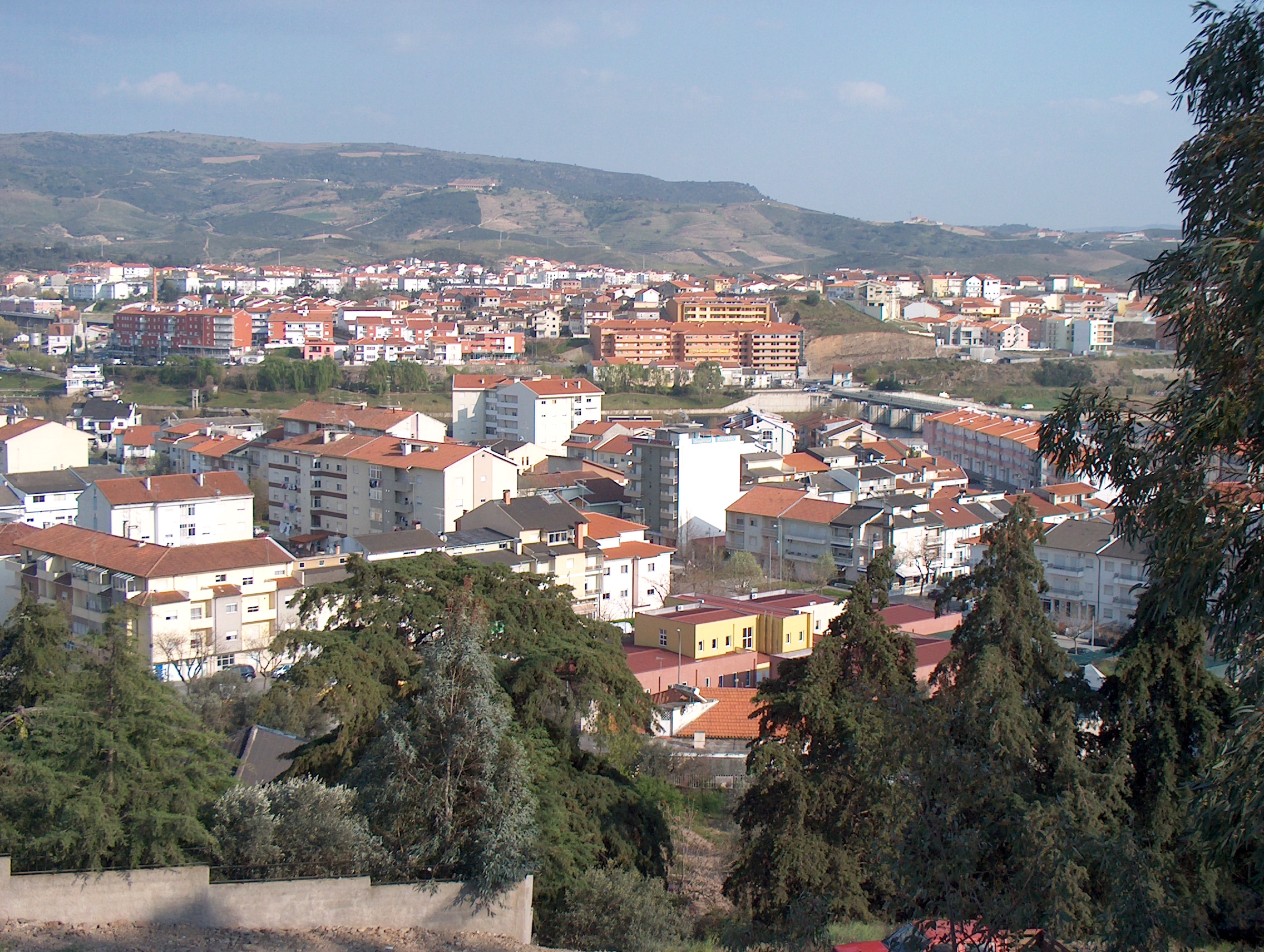
Mirandela Municipality (Concelho) 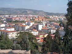 Panoramic vista of the municipal seat of Mirandela
 Flag
Flag Coat of arms
Official name: Concelho de Mirandela Nickname: Cidade Jardim (English: Garden City) Country  Portugal
Region Norte Subregion Alto Trás-os-Montes District Bragança Municipality Mirandela Center Mirandela - elevation 301 m (988 ft) - coordinates 41°32′4″N 7°11′53″W / 41.53444°N 7.19806°W Length 45.34 km (28 mi), Southwest-Northeast Width 27.78 km (17 mi), Northwest-Southeast Area 658.96 km2 (254 sq mi) Population 25,780 (2001) Density 39.12 / km2 (101 / sq mi) LAU Concelho/Câmara Municipal - location Praça do Município, Mirandela, Mirandela - elevation 231 m (758 ft) - coordinates 41°29′7″N 7°10′54″W / 41.48528°N 7.18167°W President José Maria Lopes Silvano (PPD-PSD) Municipal Chair José Manuel Pavão (PPD-PSD) Timezone WET (UTC0) - summer (DST) WEST (UTC+1) ISO 3166-2 code PT- Postal Zone 5370-288 Mirandela Area Code & Prefix (+351) XXX XXX XXX Demonym Mirandelense Patron Saint Nossa Senhora do Amparo Municipal Address Praça do Município
5370-288 MirandelaMunicipal Holidays 25 May 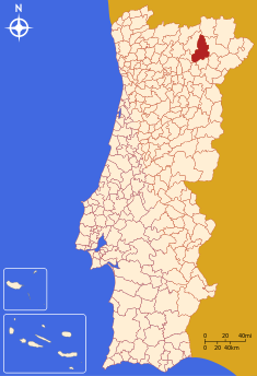 Location of the municipality of Mirandela do Douro in continental Portugal
Wikimedia Commons: Mirandela Website: http://www.cm-mirandela.pt Statistics from INE (2004); geographic detail from Instituto Geográfico Português (2010) Mirandela is a municipality of 25,780 inhabitants, in the northeast corner of Portugal.
History
The settlements of Mirandela date back to the pre-historical period, but primarily relate to a period of Roman occupation. During this era, the main settlement of Mirandela was a Roman civitas, known then as Caladunum. There are abundant vestiges of the Roman occupation in Castelo Velho, São Martinho, Mourel and Prado Pequeno, that include copper coins from the reign of Emperor Tiberius.[1] At this time the civitas was located in the region of São Martinho, but there are conflicting references as to the location of the main settlement, and when it was moved.[1] Ernesto de Sales, referenced three documents that localized the Christian village near São Martinho (even as another document in 1258 disputed the existence of the village of Mirandela in or near this region)[1]:
- a charter, written by King Sancho I to Garcia Mendes, in 1198, to a location in Vilar de Maçada;
- a charter, written by King Afonso III conceded on 25 May 1250 to Mirandela; and
- a receipt made by notary in Mirandela, on 27 March 1275.
It is clear, from the documents of King Denis, at the time when he was elaborating the defenses of the city of Guarda (2 September 1282), the transfer of the town of Mirandela to hilltop of mount São Miguel (where a small hermitage chapel existed at the time) had likely already occurred.[1] This location was easily defendable and dominated the view of the fertile lands and river access.[1]
King Afonso III granted a foral (charter) on 25 May 1250. The magistrate of Mirandela at the time governed a region that included Torre de D. Chama, Frechas, Sesulfe, Nozelos, Vilas Boas, Vale de Asnes and Cortiços.[1]
This document was expanded and elaborated by King Denis of Portugal, when he issued an updated foral on 7 March 1291, that also stipulated that every villager, who was able to do so, contribute a horse and arms and annual stipend on São Miguel day, in September.[1] King Denis also ordered the construction of protective walls around the main settlement and keep to support military needs. By the beginning of the 16th century, there were no remnants of a castle or walls.[1] The castle was then describe as having three gates (Santo António, Santiago and Portela) and small doorway (São José), in addition to a traitors-gate near Quebra-Costas. It also included battlements and interior keep, near the prison block, that served as the royal residence, on his return.[1]
The Távora family was donated Mirandela around 1301, when King Denis signed over its title to Branca Lourenço, remaining in this hereditary clan until Francisco de Assis de Távora (1721-1759).[1]
The new foral later outlined the geographic divisions of the municipality. Between 1530 and 1835, the municipality of Mirandela included the following 44 places and 9 estates: Abambres, Ala, Alvites, Avantes, Brinço, Cabanelas, Caravelas, Carvalhais, Cedães, Cedainhos, Chelas, Contins, Freixeda, Mascarenhas, Miradeses, Mirandela, Pousadas, Quintas, São Salvados, Val de Lobo, Val de Salgueiro, Valtelhas, Vila Nova, Vila Verde and Vilar de Ledra.[1] Similarly, between 1512 and 1871, the region underwent a series of territorial divisions that included the creation (and eventual suppression) of the municipalities of Torre de Chama, Frechas, Vale de Asnes, Abreiro, Lamas de Orelhão. Torre de Chama would be the most discontinuous: it was created 1287 by King Denis, but suppressed in 12 September, later to be resuscitated on 4 May 1512 by King Manuel, and then extinguished in 1855. A royal decree on 18 July 1835, preceded another territorial division that caused the elimination of various parishes and municipalities: Mirandela was left with 40 parishes (that included Cedainhos and Vale da Sancha).[1] By 1884, the municipality of Mirandela had the established geographic boundaries.
The town of Mirandela was elevated to the status of city on 28 June 1984.
Geography
Population of
Mirandela
(1706 - 1911)Year Pop. ±% 1706 1,735 — 1822 5,160 +197.4% 1864 20,031 +288.2% 1890 19,818 −1.1% 1900 20,855 +5.2% 1911 22,063 +5.8% The municipality is composed of 37 civil parishes and is located in the district of Bragança. It is bordered by the municipalities of Murça, Valpaços, Vinhais, Bragança, Macedo de Cavaleiros, Vila Flor and Carrazeda de Ansiães.
- Abambres
- Abreiro
- Aguieiras
- Alvites
- Avantos
- Avidagos
- Barcel
- Bouça
- Cabanelas
- Caravelas
- Carvalhais
- Cedães
- Cobro
- Fradizela
- Franco
- Frechas
- Freixeda
- Lamas de Orelhão
- Marmelos
- Mascarenhas
- Mirandela
- Múrias
- Navalho
- Passos
- Pereira
- Romeu
- São Pedro Velho
- São Salvador
- Suçães
- Torre de Dona Chama
- Vale de Asnes
- Vale de Gouvinhas
- Vale de Salgueiro
- Vale de Telhas
- Valverde
- Vila Boa
- Vila Verde
It contains the city of Mirandela.
References
- Notes
Alfândega da Fé · Bragança · Carrazeda de Ansiães · Freixo de Espada à Cinta · Macedo de Cavaleiros
Miranda do Douro · Mirandela · Mogadouro · Torre de Moncorvo · Vila Flor · Vimioso · Vinhais Categories:
- Municipalities of Bragança

Wikimedia Foundation. 2010.