Middle Fork Kings River

Middle Fork Kings River
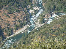
The mouth of the Middle Fork (left) where it joins the South Fork (right) to form the Kings River (lower left)

The Middle Fork Kings River is a major tributary of the Kings River in the U.S. state of California. The river flows 37.2 miles (59.9 km)[1] in a generally southwest direction, entirely within Kings Canyon National Park and the Sierra Nevada. Its drainage basin is roughly 500 square miles (1,300 km2) in size. The river joins the South Fork Kings River at its mouth to form the main stem of the Kings River.

See also

References

  1. ^ U.S. Geological Survey. National Hydrography Dataset high-resolution flowline data. The National Map, accessed March 11, 2011

36°50′18″N 118°52′30″W / 36.83833°N 118.875°W / 36.83833; -118.875Coordinates: 36°50′18″N 118°52′30″W / 36.83833°N 118.875°W / 36.83833; -118.875


Wikimedia Foundation. 2010.

Игры ⚽ Поможем написать реферат

Look at other dictionaries:

  • Middle Fork Feather River — Coordinates: 39°38′29″N 121°17′11″W / 39.64139°N 121.28639°W / 39.64139; 121.28639 …   Wikipedia

  • North Fork Kings River — Coordinates: 36°52′10″N 119°08′06″W / 36.86944°N 119.135°W / 36.86944; 119.135 …   Wikipedia

  • Kings River (Kalifornien) — Kings River Südarm des Kings River im Kings CanyonVorlage:Infobox Fluss/KARTE fehlt Daten …   Deutsch Wikipedia

  • North Fork Feather River — River Milsap Bar crossing on the North Fork Feather River …   Wikipedia

  • Kings River (California) — The Kings River is a major river of California, USA. It arises in the Sierra Nevada, consisting of three forks. The Middle and South Forks start in Kings Canyon National Park, while the North Fork starts in the John Muir Wilderness. The South… …   Wikipedia

  • Tule River — Coordinates: 36°02′59″N 119°49′27″W / 36.04972°N 119.82417°W / 36.04972; 119.82417 …   Wikipedia

  • Kaweah River — Coordinates: 36°20′12″N 119°13′23″W / 36.33667°N 119.22306°W / 36.33667; 119.22306 …   Wikipedia

  • Kern River — Coordinates: 35°16′4″N 119°18′25″W / 35.26778°N 119.30694°W / 35.26778; 119.30694 …   Wikipedia

  • Kings Canyon National Park — Infobox protected area | name = Kings Canyon National Park iucn category = II caption = locator x = 22 locator y = 85 location = Fresno County Tulare County, California, USA nearest city = Fresno lat degrees = 36 lat minutes = 48 lat seconds = 0… …   Wikipedia

  • Chowchilla River — Coordinates: 37°6′21″N 120°30′38″W / 37.10583°N 120.51056°W / 37.10583; 120.51056 …   Wikipedia

Share the article and excerpts

Direct link
Do a right-click on the link above
and select “Copy Link”