- Mentawai Islands Regency
-
Mentawai Islands Regency
Kepulauan Mentawai— Regency — 
Coordinates: 2°11′S 99°39′E / 2.183°S 99.65°ECoordinates: 2°11′S 99°39′E / 2.183°S 99.65°E Country Indonesia Province West Sumatra Capital Tua Pejat Government - Regent Edison Saleleubaja Area - Total 6,011.35 km2 (2,321 sq mi) Population (2010) - Total 76,421 - Density 12.7/km2 (32.9/sq mi) Time zone WIB (UTC+7) The Mentawai Islands are a chain of about seventy islands and islets off the western coast of Sumatra in Indonesia. Siberut (4,030 km²) is the largest of the islands. The other major islands are Sipura, North Pagai (Pagai Utara) and South Pagai (Pagai Selatan). The islands lie approximately 150 km off the Sumatran coast, across the Mentawai Strait. The indigenous inhabitants of the islands are known as the Mentawai people. The Mentawai Islands have become a noted destination for surfing. Mentawai Islands waves are one of two best surfing location in the world.[1]
Contents
History
Following the Pleistocene glaciation, the Mentawai Islands were separated once more from the Sumatran mainland by rising sea levels. The Mentawai people are estimated to have arrived on the islands somewhere between 2000 and 500 BCE, migrating from the north through Siberut and then moving south to Sipora and the Pagai islands. Their Austronesian language, their customs and habits of life indicated as early as Crisp's report an origin that was distinct from the nearby coast of Sumatra.
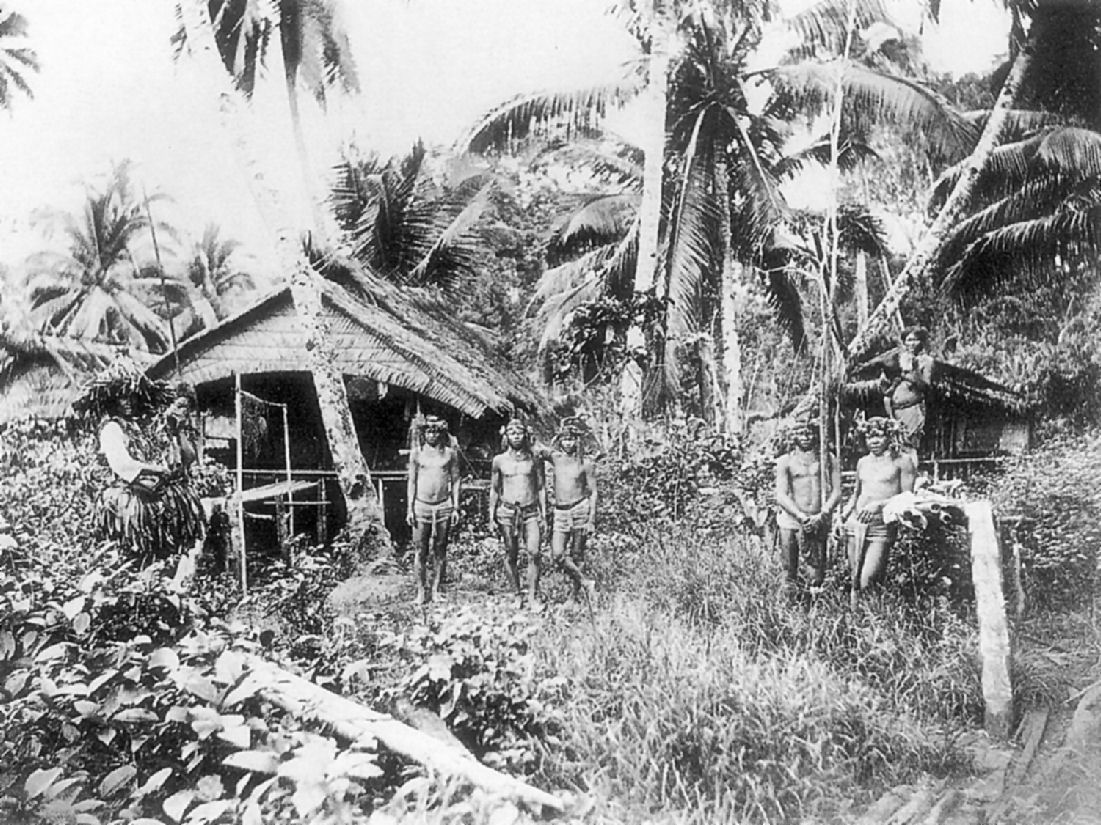
 A Mentawai village in 1895.
The Portuguese were aware of the islands early in the 17th century: a map dated 1606 shows Siberut as "Mintaon". In August 1792 John Crisp, an employee of the British East India Company, visited the Pagai ("Poggy") islands at his own expense to study the Mentawai people. His account was published in 1799,[2] providing the first details of the Mentawai people in western literature. The Mentawai Islands officially became part of the Dutch East Indies on 10 July 1864, not having been subject to the Anglo-Dutch Treaty of 1824. In 1901 the German Royal Missionary Society established a presence on the south coast of North Pagai island at the invitation of the Dutch colonial authorities. The first missionary was murdered, and it wasn't until 1915 that the first person was converted, with the program then being extended to other islands.
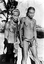 Mentawai Islanders, picture taken 1930.
After Indonesian independence, Catholic Italian missionaries established a presence in the islands. Post-independence government policies relocated the indigenous population into villages, in contrast to their traditional dispersed house groups (uma), with the aim of promoting "development". Cultural tourism started to develop in the late 1980s, and when in the mid-1990s world-class waves were discovered by some Australian surfers, surfing tourism started to develop.
The island of Siberut was extensively logged from the 1970s after the government granted logging permits for most of the island. In 1993, the logging concessions were revoked and about half the island was declared a national park. In 2001 logging recommenced after a new logging permit was granted for an area of 500 km².
Administration
The Mentawai Islands have been administered as a regency within the West Sumatra (Sumatera Barat) province since 1999. The regency seat is Tua Pejat, located on the island of Sipura. Padang, the capital of the province, lies on the Sumatran mainland opposite Siberut. The regency is divided in ten subdistricts (kecamatan), from north to south these comprise:
- Siberut Utara (North Siberut)
- Siberut Barat (West Siberut)
- Siberut Tengah (Mid Siberut)
- Siberut Selatan (South Siberut)
- Siberut Barat Daya (Southwest Siberut)
- Sipora Utara (North Sipura)
- Sipora Selatan (South Sipura)
- Sikakap (Sikakap)
- Pagai Utara (North Pagai)
- Pagai Selatan (South Pagai)
Ecology
 Mentawai Islands Topography
The islands have been separated from Sumatra since the mid-Pleistocene period, which has allowed at least twenty endemic species to develop amongst its flora and fauna. This includes five endemic primates: the Mentawai or Kloss Gibbon (Hylobates klossii), Mentawai Macaque (Macaca pagensis), Siberut Macaque ("Macaca siberu"), Mentawai leaf-monkey (Presbytis potenziani), and snub-nosed monkey (Simias concolor). Some areas of the Mentawai Islands rain forest ecoregion are protected, such as the Siberut National Park. Red Junglefowl and the Crab-eating macaque are also native.
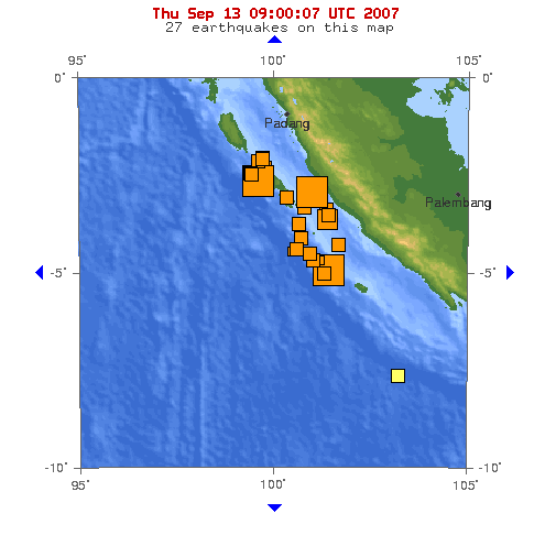
Seismic activity
See also: October 2010 Sumatra earthquakeThe Mentawai Islands lie above the Sunda megathrust, a seismically active zone responsible for many great earthquakes. This megathrust runs along the southwestern side of Sumatra island, forming the interface between the Eurasian Plate and Indo-Australian Plate.
Earthquake and tsunami activity has been high since the 2004 Indian Ocean earthquake. In 1833, the region was hit with an earthquake, possibly similar in size to the 2004 Indian Ocean Earthquake[3]; another large earthquake struck in 1797. On October 25, 2010, an earthquake in southern Sumatra led to a deadly tsunami that devastated villages in South and North Pagai.[4]
See also
- Mentawai ethnic group
Notes
- ^ http://www.balifornian.com/blog/2010/12/23/surfing-in-bali-everything-you-need-to-know-except-a-few-sec.html
- ^ J. Crisp (1799) "An account of the inhabitants of the Poggy Islands lying off Sumatra". Asiatick Researches 6:77-91; noted at Mentawai.org.
- ^ Indonesia Great Earthquakes
- ^ "Indonesia Earthquake and Tsunami Kill 113, Merapi Volcano Eruptions Hours Later". News article. politiktimes.com. October 26, 2010. http://politiktimes.com/top-news/3-international-news/473-indonesia-earthquake-and-tsunami-kill-113-merapi-volcano-eruptions-hours-later.html. Retrieved October 26, 2010.
External links
- Anthropology of the Mentawai Islands
- Native Planet: The Mentawai
- Mentawai Islands rain forests (World Wildlife Fund)
- Surf Aid International
Regencies and Cities of West Sumatra Capital: Padang Regencies Agam • Dharmasraya • Limapuluh Koto • Mentawai Islands • Padang Pariaman • Pasaman • South Pesisir • Sijunjung • Solok • South Solok • Tanah Datar • West Pasaman

Cities Bukittinggi • Padang • Padang Panjang • Pariaman • Payakumbuh • Sawahlunto • Solok
See also: List of regencies and cities of Indonesia Categories:- Regencies of West Sumatra
- Mentawai Islands
- Archipelagoes of Indonesia
- Tropical and subtropical moist broadleaf forests
- Surfing locations in Indonesia
- Volcanic arc islands
- Islands of Sumatra


Wikimedia Foundation. 2010.