- September 2007 Sumatra earthquakes
Earthquake
title=September 2007 Sumatra earthquakes
date=September 12 ,2007 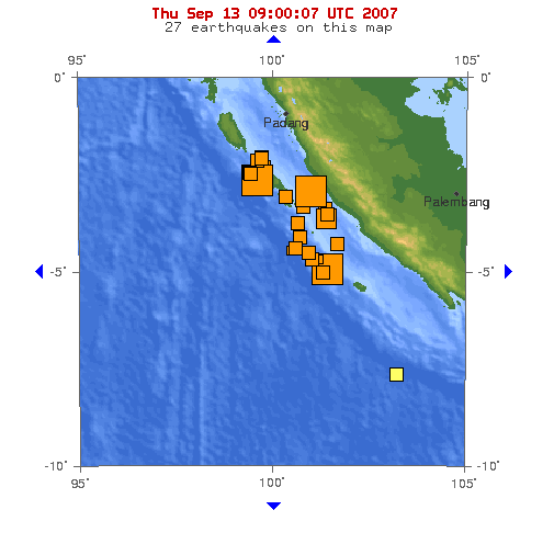
Map showing the 3 large quakes and 22 pre and aftershocks in a span of 24 hours.
magnitude = 8.5 Mw [http://www.alertnet.org/thenews/newsdesk/N12258139.htm Indonesia quake was 8.4 magnitude, says USGS] ,Reuters ]
depth=30 kilometres
location=coord|4.520|S|101.374|E
countries affected = flag|Indonesia
flag|Singapore
flag|Malaysia
flag|Thailand
casualties = 23 killed [The Jakarta Post. [http://www.webcitation.org/5RtsfHEFK "Death toll from Indonesian quake reaches 23 as villagers start returning home"] ,September 16 2007 ]The September 2007 Sumatra earthquakes were a series of
earthquake s that struck theJava Trench off the coast ofSumatra ,Indonesia , three greater than magnitude 7. A series oftsunami bulletins was issued for the area.Timeline
The first earthquake occurred at 11:10:26 UTC (18:10 local time) on
12 September 2007 , and was an 8.5 Mwearthquake on themoment magnitude scale . It was centered about 34 km underground, at coord|4.520|S|101.374|E, about 130 km southwest of Bengkulu on the southwest coast ofSumatra ,Indonesia , and some 600 km west-northwest of Indonesia's capital city,Jakarta . It was followed by several earthquakes of magnitude 5 through 6 along the same fault, west of Sumatra.The second largest earthquake, 7.9 Mw, [ [http://earthquake.usgs.gov/eqcenter/recenteqsww/Quakes/us2007hec6.php KEP. MENTAWAI REGION, INDONESIA] ,
USGS ] occurred later the same day at 23:49:04 UTC (06:49:04 local time the following day). It was centred about 10 km underground, at coord|2.506|S|100.906|E, some 185 km (115 miles) south-southeast ofPadang, Indonesia and about 205 km northwest of Bengkulu (about 225 km northwest of the magnitude 8.5 earthquake).After further aftershocks above magnitude 5, a third earthquake, 7.0 Mw, [ [http://earthquake.usgs.gov/eqcenter/recenteqsww/Quakes/us2007hfax.php Magnitude 7.0 - KEPULAUAN MENTAWAI REGION, INDONESIA] ,
USGS ] occurred at 03:35:26 UTC (10:35:26 local time) on13 September . It was centred about 10 km underground, at coord|2.160|S|99.851|E, some 165 km south-southwest of Padang and 345 km west-northwest of Bengkulu.Aftershocks continued into
13 September and14 September , with more earthquakes ranging up to magnitude 6.4. [ [http://earthquake.usgs.gov/eqcenter/recenteqsww/Quakes/quakes_big.php Latest Quakes +5.0M]USGS ] Most of the aftershocks have been northwest of the original magnitude 8.4 earthquake.Tidal buoys [ [http://www.ndbc.noaa.gov/station_page.php?station=23401 DART Buoy Station 23401 - 600 NM West-Northwest of Phuket, Thailand] ] positioned in the
Indian Ocean and other seismic tools have led scientists to issue a series of tsunami bulletins. [ [http://www.prh.noaa.gov/ptwc/?region=3&id=indian.2007.09.13.002807 Message indian.2007.09.13.002807 Pacific Tsunami Warning Center, NWS] ,NWS PTWC ]Effects
The tremors of the 8.5 Mw earthquake lasted for several minutes. It caused buildings to sway in Jakarta, and some buildings were reported to have collapsed in the city of Bengkulu, Province Bengkulu, about 100 km from the
epicenter . Tremors felt in Jakarta were described as being "violent". [ [http://news.bbc.co.uk/2/hi/asia-pacific/6991294.stm Eyewitnesses: Sumatra earthquake] ,BBC News ] It was reported that several high-rise buildings were evacuated. [http://news.bbc.co.uk/2/hi/asia-pacific/6991134.stm Powerful quake shakes Indonesia] ,BBC News ] At least one person was killed, having been struck by a falling tree during evacuation, and dozens were injured. The earthquake also led to a power outage in Bengkulu, which has crippled communications. Consequently, the extent of damage in areas near the epicenter remains largely unknown. The death toll of the earthquakes is 21 with 88 people injured. [ [http://www.alertnet.org/thenews/newsdesk/SP40512.htm Reuters AlertNet - Indonesia quake toll rises to 21 dead, 88 wounded ] ]Tremors were felt in neighbouring countries as far away as
Southern Thailand . [ [http://www.channelnewsasia.com/stories/afp_asiapacific/view/299424/1/.html Tsunami alert issued after Indonesia quake: US centre] ] [ [http://pasadena.wr.usgs.gov/shake/ous/STORE/X2007hear/ciim_display.html Event 2007hear: View Map] ] InSingapore , which is about 670 km from the epicenter, the tremor was felt at around 11:10 UTC (19:10 local time). [ [http://www.channelnewsasia.com/stories/singaporelocalnews/view/299419/1/.html Singapore buildings sway after strong quake hits Indonesia] ] Most of the Central and Eastern part ofSingapore has felt the tremor. [ [http://www.channelnewsasia.com/tremor/map.htm Map] ] InPeninsular Malaysia , tremors were reported after 19:15 local time, includingKuala Lumpur ,Putrajaya ,Johor Bahru ,Malacca andPenang . Like Singapore, the tremors were most severe on high-rises, resulting in minor panic and evacuations. No casualties were reported in the country, as ofSeptember 13 .cite web |url=http://www.sun2surf.com/article.cfm?id=19325 |title=8.2 magnitude quake sparks tsunami warnings |accessdate=2007-09-13 |author= |date=2007-09-13 |publisher=Sun2Surf ] cite web |url=http://www.thestar.com.my/news/story.asp?file=/2007/9/13/nation/18874029&sec=nation&focus=1 |title=Quake felt in Malaysia |accessdate=2007-09-13 |author= |date=2007-09-13 |publisher="The Star" ]Tsunami
Sea level readings indicated that a
tsunami was generated. A total of 4 tsunami alerts were issued in 24 hours. After the first, and largest, earthquake, thePacific Tsunami Warning Centre issued a tsunami alert for much of theIndian Ocean basin. A tsunami approximately 1 metre high was reported atPadang, Indonesia . [ [http://www.thejakartapost.com/detailgeneral.asp?fileid=20070912203110&irec=2 Powerful earthquake triggers tsunami in western Indonesia] , "The Jakarta Post "] A small tsunami, some 15 cm high, was reported at theCocos Islands . [ [http://www.news.com.au/heraldsun/story/0,21985,22410200-5005961,00.html Tsunami recorded at Cocos Island] ,Herald Sun ] Sumatra was taken off tsunami alert after two hours.Tsunami warnings were also issued in
India and other countries around the Indian Ocean soon after the earthquake. TheGovernment of India asked the states ofTamil Nadu ,Kerala ,Andhra Pradesh and the union territories ofAndaman and Nicobar Islands andPuducherry to be on high alert. [ [http://www.ibnlive.com/news/india-on-tsunami-alert-after-quake-near-indonesia/48531-2.html India on tsunami alert after quake near Indonesia] , "CNN-IBN "] By lateSeptember 12 , the tsunami warning was recalled. [ [http://www.hindu.com/2007/09/13/stories/2007091357940100.htm Tsunami alert withdrawn] . "The Hindu "] Similarly, a tsunami alert was issued inPeninsular Malaysia at 20:50 (local time) for the coastal areas ofPerlis ,Kedah ,Perak andPenang ; the alert was lifted two hours later. However, Malaysian authorities had detected a 1-3m high tsunami heading away from the epicenter of the earthquake.Tectonic summary
According to the
US Geological Survey , [http://earthquake.usgs.gov/eqcenter/recenteqsww/Quakes/us2007hear.php#summary Magnitude 8.5 - Southern Sumatra, Indonesia] ] the earthquake was caused bythrust fault ing on the boundary between the Australian Plate and the Sunda Plate. At the location of the earthquake, offshore of the west coast of Sumatra, the Australia plate moves northeast with respect to the Sunda Plate at avelocity of about 69 mm/year, oblique to the orientation of the plate boundary. The component of plate motion perpendicular to the boundary produces thrust faulting on the offshore plate-boundary.The magnitude 7.9 earthquake was also a result of thrust faulting on the same plate boundary. It occurred about 225 km northwest of the magnitude 8.4 earthquake, at the northern end of the aftershock zone. [ [http://earthquake.usgs.gov/eqcenter/recenteqsww/Quakes/us2007hec6.php#summary Magnitude 7.9 - KEPULAUAN MENTAWAI REGION, INDONESIA ] ]
The magnitude 8.5 earthquake was the most powerful earthquake of 2007 to date, more powerful than the two
March 2007 Sumatra earthquakes nearby and the2007 Peru earthquake . It was the second most powerful earthquake since the magnitude 9.32004 Indian Ocean earthquake , exceeded only by the magnitude 8.62005 Sumatra earthquake . The two largest earthquakes were the fourth and fifth earthquakes with magnitude 7.9 or greater to have occurred on or near the plate boundaries offshore of western Sumatra in 7 years, the others being the magnitude 7.9 earthquake ofJune 4 ,2000 ; the magnitude 9.32004 Indian Ocean earthquake onDecember 26 ,2004 ; and the magnitude 8.62005 Sumatra earthquake onMarch 28 ,2005 .According to data from the Japanese
PALSAR microwave sensor aboard the Daichi(ALOS)satellite ,South Pagai Island was uplifted, creating 6 new islands, and exposing previously submergedcoral reefs as well as enlarging existing islands. [ja icon [http://cais.gsi.go.jp/Research/topics/topic071001/rgb_e.html Southern Sumatra Earthquake in 2007, coastal change, GSI ] ]References
External links
* [http://earthquake.usgs.gov/eqcenter/recenteqsww/Quakes/us2007hear.php USGS Earthquake Center 8.5 tracking report]
* [http://earthquake.usgs.gov/eqcenter/recenteqsww/Quakes/us2007hec6.php USGS Earthquake Center 7.9 tracking report]
* [http://earthquake.usgs.gov/eqcenter/recenteqsww/Quakes/us2007hfax.php USGS Earthquake Center 7.0 tracking report]
* [http://wcatwc.arh.noaa.gov/message622582-01.htm Tsunami Information Statement #1] , NOAA/NWS/West Coast and Alaska Tsunami Warning Center
* [http://www.prh.noaa.gov/ptwc/messages/indian/2007/indian.2007.09.12.123044.txt Tsunami bulletin number 003] ,Pacific Tsunami Warning Center /NOAA /NWS
Wikimedia Foundation. 2010.