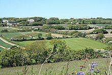
- Menagissey
-
Coordinates: 50°16′30″N 5°12′45″W / 50.27513°N 5.21258°W
Not to be confused with Mevagissey.Menagissey is a hamlet in Cornwall, United Kingdom. It is situated half-a-mile south of Mount Hawke approximately three miles (5 km) north-northeast of Redruth[1] in the civil parish of St Agnes.
The settlement consists of cottages, bungalows and farms above a steep valley[2].
References
- ^ Ordnance Survey: Landranger map sheet 203 Land's End ISBN 978-0-319-23148-7
- ^ [1] Into Cornwall website; Menagissey; retrieved April 2010
Geography of Cornwall Cornwall Portal Unitary authorities Major settlements Bodmin • Bude • Callington • Camborne • Camelford • Falmouth • Fowey • Hayle • Helston • Launceston • Liskeard • Looe • Lostwithiel • Marazion • Newlyn • Newquay • Padstow • Par • Penryn • Penzance • Porthleven • Redruth • Saltash • St Austell • St Blazey • St Columb Major • St Ives • St Just-in-Penwith • St Mawes • Stratton • Torpoint • Truro • Wadebridge
See also: Civil parishes in CornwallRivers Topics History • Status debate • Flag • Culture • Places • People • The Duchy • Diocese • Politics • Hundreds/shires • Places of interest • full list...Categories:- Villages in Cornwall
- Cornwall geography stubs
Wikimedia Foundation. 2010.

