- Meadow Lake, Nevada County, California
-
Meadow Lake
Excelsior, Summit City— Former settlement —  Location in California
 Meadow Lake
Coordinates: 39°24′12.6″N 120°29′53.88″W / 39.4035°N 120.4983°WCoordinates: 39°24′12.6″N 120°29′53.88″W / 39.4035°N 120.4983°W Country  United States
State  California
County Nevada County Township February, 1866 Elevation[1] 7,293 ft (2,223 m) Meadow Lake (previously: Excelsior; Summit City) is a former settlement in Nevada County, California, USA. Situated at an elevation of 7,290 ft (2,220 m) above sea level,[2] the reservoir of the same name is one of the highest lakes in elevation within the Tahoe National Forest.
History
The demand for water to work the auriferous claims scattered in the foothills and valleys of Northern California's Nevada and Sierra counties brought attention to the Meadow Lake region as there was an inexhaustible supply of water, which could be collected in reservoirs and conducted by aqueducts to lower elevation mining locales. In the summer of 1858, the first permanent structure was erected in the Meadow Lake area, consisting of a stone wall across a 900 feet (270 m) ravine, forming the Meadow Lake reservoir. From it, Nevada City and southwestern Nevada County, obtained their principal supply of water during several months of the year. It measures 50 feet (15 m) in height, 15 feet (4.6 m) width at its apex, and is built of granite.[3]
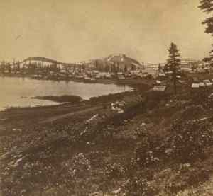
In 1860, Henry Hartley arrived in the locale to trap. By 1863, he noticed some quartz ledges, and incorporated the "Excelsior Company". The town's heyday occurred during the period of 1865 to 1868 with the economy built on the prospect of finding substantial gold ore. In 1866, Meadow Lake was founded as the county's ninth township.[3] Also known at one time as Summit City, an excursion vessel took revelers up the lake to hurdy gurdy houses.[4] Hurdy gurdy halls apparently so-called because of the presence of the "hurdy gurdy girls". They appear to be the upper level of the dance hall girls of the American frontier fact and fiction. At its peak, there were 500 buildings and the population numbered up to 5,000 residents. By 1868, the population had dropped to fewer than 100 residents.[5]
Not much of the townsite remains. However, there are several mining sites, a few foundations, the cemetery, and the dam.[5] A campsite is located near the shore of the lake, and available activities include canoeing, fishing, and hiking. The Ranger Station is located in Sierraville.[6]
Geography
The township was bound on the north by Sierra County, on the south by Placer, on the east by the state of Nevada, and on the west by the townships of Eureka and Washington. It is reachable via California State Route 89 northbound from Truckee, though the last nine miles are on a logging road.[5] About 2 miles (3.2 km) west of Meadow Lake lies another reservoir called French Lake.
The reservoir lies within the town limits and is discharged by a small gate at the dam. It is about 2 miles (3.2 km) long and approximately .75 miles (1.21 km) wide. Its depth ranges between ten to thirty fathoms.[3]
Prominent landscape features include immense forests, luxuriant grasses, huge boulders, and masses of granite.[3]
References
- ^ U.S. Geological Survey Geographic Names Information System: Meadow Lake, Nevada County, California
- ^ "Meadow Lake Fishing in Nevada County, California Webber Peak Area". fishingworks.com. http://www.fishingworks.com/lakes/california/nevada/webber-peak/meadow-lake/. Retrieved 18 April 2011.
- ^ a b c d Bean's history and directory of Nevada County, California: Containing a complete history of the county, with sketches of the various towns and mining camps ... also, full statistics of mining and all other industrial resources. Printed at the Daily Gazette Book and Job Office. 1867. pp. 305–306. http://books.google.com/books?id=lHFNAAAAYAAJ&pg=PA305. Retrieved 18 April 2011.
- ^ "#61 Name: Meadow Lake". E Clampus Vitus. http://www.ecv58.com/monuments/meekchp10/chap10.htm. Retrieved 21 April 2011.
- ^ a b c Perez, Jim. "Meadow Lake". ghosttowns.com. http://www.ghosttowns.com/states/ca/meadowlake.html. Retrieved 18 April 2011.
- ^ "Meadow Lake Campground, California". publiclands.org. http://www.publiclands.org/explore/site.php?id=5665. Retrieved 18 April 2011.
Municipalities and communities of Nevada County, California County seat: Nevada City Cities and towns 
CDPs Alta Sierra | Floriston | Graniteville | Kingvale‡ | Lake of the Pines | Lake Wildwood | North San Juan | Penn Valley | Rough and Ready | Soda Springs | Washington
Unincorporated
communitiesAlta Hill | Bitney Corner | Carpenter Valley | Casey Corner | Cedar Ridge | Chicago Park | Coleman | Crystal Lake | Dew Drop | French Corral | Forest Knolls | Gaston | Gateway | Gold Flat | Higgins Corner | Hills Flat | Hinton | Hirschdale | Junction House | Kres | Lake City | Marsh Mill | Mooney Flat | Mystic | Newtown | Norden | North Bloomfield | North Columbia | Peardale | Pinecrest | Polaris | Relief | Scotts Flat | Sebastopol | Spring Hill | The Oaks | Town Talk | Union Mills | Willow Valley | Wolf | You Bet | Yuba Pass
Ghost towns Alpha | Badger Hill | Balaklava | Bald Eagle | Baltimore Town | Bear River Pines | Bear Valley | Beckmans Flat | Birchville | Blue Tent | Boca | Boston Ravine | Brass Wire Bar | Bridgeport | Brighton House | Bronco | Buena Vista | Burckhalter | Burks Bar | Camp Spaulding | Cascade Diggings | Cedar Kress | Chalk Bluff | Champion | Cherokee | Coyoteville | Crystal Springs | Democrat | Diamond Creek | Diggers Bar | Dillon | Drum | Eagle Bird | Elida | Eureka | Excelsior | Farad | Fernley | Flood | Forest Spring | French Lake | Frenchmans Bar | Gelatt | Glenbrook | Gold Hill | Hacketville | Hobart Mills | Hunt's Hill | Iceland | Indian Springs | Jericho | Jones Bar | La Barr Meadows | Lafayette Hill | Langs | Little York | Louisa | Lowell Hill | Malakoff | Maybert | Meadow Lake | Melburn Hill | Missouri Flat | Moores Flat | Mount Zion | Mountain Well | Mountain View | Negro Flat | Ohm | Omega | Orleans Flat | Pittsburg | Pleasant Flat | Prosser | Prosser Creek | Providence | Randolph House | Rays Flat | Red Diamond | Red Dog | Remington Hill | Rose's Corral | Shands | Shelby Flat | Shellback | Six Mile House | Snow Point | Snow Tent | Spenceville | Spiritsville | Stockings Flat | Sunset View | Sweetland | Tsekankan | Union Hill | Ustoma | Virginia House | Waloupa | White Cloud | Wickes | Wilsonville | Wokodot | Woolsey Flat | Yamako | Zinc House
Footnotes ‡This CDP also has portions in an adjacent county or counties
Categories:- Former settlements in Nevada County, California
- Former populated places in California
- Populated places established in 1866
- Reservoirs in California


Wikimedia Foundation. 2010.