- North San Juan, California
-
North San Juan — census-designated place — Downtown North San Juan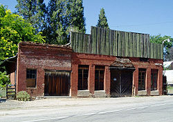 Location of Lake City in California

Coordinates: 39°22′17″N 121°06′26″W / 39.37139°N 121.10722°WCoordinates: 39°22′17″N 121°06′26″W / 39.37139°N 121.10722°W Country  United States
State  California
County Nevada Area[1] – Total 2.422 sq mi (6.272 km2) – Land 2.422 sq mi (6.272 km2) – Water 0 sq mi (0 km2) 0% Elevation[2] 2,172 ft (662 m) Population (2010) – Total 269 – Density 111.1/sq mi (42.9/km2) Time zone Pacific (PST) (UTC-8) – Summer (DST) PDT (UTC-7) ZIP code 95960 Area code(s) 530 GNIS feature ID 2628766 U.S. Geological Survey Geographic Names Information System: North San Juan, California North San Juan is a census-designated place[2] in Nevada County, California, United States,[2] along State Route 49 on the San Juan Ridge in Gold Country. The zip code is 95960. The population was 269 at the 2010 census.
Contents
History
The community's beginnings date back to the California Gold Rush and it prospered during the era of hydraulic mining at nearby Malakoff Diggins State Historic Park from 1850-1884. Beginning in 1867, it was included on the route for the first long-distance telephone line, a historical landmark, between French Corral and French Lake.[3][4]
In 1880, the population was 675.[5]
The original name San Juan was bestowed by a veteran of the Mexican-American War who settled there in 1853 because he thought the site looked like San Juan de Ulúa near Veracruz. When the post office opened in 1857 "North" was added to distinguish it from San Juan in San Benito County.[6]
Geography
According to the United States Census Bureau, the CDP covers an area of 2.4 square miles (6.3 km²), all of it land.
Demographics
The 2010 United States Census[7] reported that North San Juan had a population of 269. The population density was 111.1 people per square mile (42.9/km²). The racial makeup of North San Juan was 224 (83.3%) White, 1 (0.4%) African American, 12 (4.5%) Native American, 11 (4.1%) Asian, 0 (0.0%) Pacific Islander, 0 (0.0%) from other races, and 21 (7.8%) from two or more races. Hispanic or Latino of any race were 9 persons (3.3%).
The Census reported that 269 people (100% of the population) lived in households, 0 (0%) lived in non-institutionalized group quarters, and 0 (0%) were institutionalized.
There were 130 households, out of which 25 (19.2%) had children under the age of 18 living in them, 38 (29.2%) were opposite-sex married couples living together, 17 (13.1%) had a female householder with no husband present, 7 (5.4%) had a male householder with no wife present. There were 13 (10.0%) unmarried opposite-sex partnerships, and 0 (0%) same-sex married couples or partnerships. 51 households (39.2%) were made up of individuals and 13 (10.0%) had someone living alone who was 65 years of age or older. The average household size was 2.07. There were 62 families (47.7% of all households); the average family size was 2.71.
The population was spread out with 43 people (16.0%) under the age of 18, 10 people (3.7%) aged 18 to 24, 67 people (24.9%) aged 25 to 44, 111 people (41.3%) aged 45 to 64, and 38 people (14.1%) who were 65 years of age or older. The median age was 49.8 years. For every 100 females there were 124.2 males. For every 100 females age 18 and over, there were 115.2 males.
There were 146 housing units at an average density of 60.3 per square mile (23.3/km²), of which 62 (47.7%) were owner-occupied, and 68 (52.3%) were occupied by renters. The homeowner vacancy rate was 1.6%; the rental vacancy rate was 0%. 137 people (50.9% of the population) lived in owner-occupied housing units and 132 people (49.1%) lived in rental housing units.
References
- ^ U.S. Census
- ^ a b c U.S. Geological Survey Geographic Names Information System: North San Juan, California
- ^ Brower, Maria E. (2006). Gold Rush Towns of Nevada County. Charleston: Arcadia Publishing. pp. p. 23. ISBN 0738546925. http://books.google.com/books?id=QKBh_CIbMLQC&pg=PA23&lpg=PA23&dq=%22French+Lake%22++%22gold+rush%22&source=web&ots=iyAFhDyD0J&sig=80nXR4jWHtHDgkEtg7EPrLlXVvA&hl=en&sa=X&oi=book_result&resnum=3&ct=result.
- ^ "French Corral Gold District". museumca.org. http://www.museumca.org/goldrush/dist-frenchcorral.html. Retrieved 2008-08-14.
- ^ "Nevada County GenWeb Nevada County History". cagenweb.com. http://www.cagenweb.com/nevada/nchistory.html. Retrieved 2009-05-31.
- ^ Durham, David L. (1998). California's Geographic Names: A Gazetteer of Historic and Modern Names of the State. Quill Driver Books. p. 531. ISBN 9781884995149.
- ^ All data are derived from the United States Census Bureau reports from the 2010 United States Census, and are accessible on-line here. The data on unmarried partnerships and same-sex married couples are from the Census report DEC_10_SF1_PCT15. All other housing and population data are from Census report DEC_10_DP_DPDP1. Both reports are viewable online or downloadable in a zip file containing a comma-delimited data file. The area data, from which densities are calculated, are available on-line here. Percentage totals may not add to 100% due to rounding. The Census Bureau defines families as a household containing one or more people related to the householder by birth, opposite-sex marriage, or adoption. People living in group quarters are tabulated by the Census Bureau as neither owners nor renters. For further details, see the text files accompanying the data files containing the Census reports mentioned above.
External links
Municipalities and communities of Nevada County, California Cities and towns 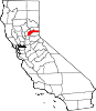
CDPs Alta Sierra | Floriston | Graniteville | Kingvale‡ | Lake of the Pines | Lake Wildwood | North San Juan | Penn Valley | Rough and Ready | Soda Springs | Washington
Unincorporated
communitiesAlta Hill | Bitney Corner | Carpenter Valley | Casey Corner | Cedar Ridge | Chicago Park | Coleman | Crystal Lake | Dew Drop | French Corral | Forest Knolls | Gaston | Gateway | Gold Flat | Higgins Corner | Hills Flat | Hinton | Hirschdale | Junction House | Kres | Lake City | Marsh Mill | Mooney Flat | Mystic | Newtown | Norden | North Bloomfield | North Columbia | Peardale | Pinecrest | Polaris | Relief | Scotts Flat | Sebastopol | Spring Hill | The Oaks | Town Talk | Union Mills | Willow Valley | Wolf | You Bet | Yuba Pass
Ghost towns Alpha | Badger Hill | Balaklava | Bald Eagle | Baltimore Town | Bear River Pines | Bear Valley | Beckmans Flat | Birchville | Blue Tent | Boca | Boston Ravine | Brass Wire Bar | Bridgeport | Brighton House | Bronco | Buena Vista | Burckhalter | Burks Bar | Camp Spaulding | Cascade Diggings | Cedar Kress | Chalk Bluff | Champion | Cherokee | Coyoteville | Crystal Springs | Democrat | Diamond Creek | Diggers Bar | Dillon | Drum | Eagle Bird | Elida | Eureka | Excelsior | Farad | Fernley | Flood | Forest Spring | French Lake | Frenchmans Bar | Gelatt | Glenbrook | Gold Hill | Hacketville | Hobart Mills | Hunt's Hill | Iceland | Indian Springs | Jericho | Jones Bar | La Barr Meadows | Lafayette Hill | Langs | Little York | Louisa | Lowell Hill | Malakoff | Maybert | Meadow Lake | Melburn Hill | Missouri Flat | Moores Flat | Mount Zion | Mountain Well | Mountain View | Negro Flat | Ohm | Omega | Orleans Flat | Pittsburg | Pleasant Flat | Prosser | Prosser Creek | Providence | Randolph House | Rays Flat | Red Diamond | Red Dog | Remington Hill | Rose's Corral | Shands | Shelby Flat | Shellback | Six Mile House | Snow Point | Snow Tent | Spenceville | Spiritsville | Stockings Flat | Sunset View | Sweetland | Tsekankan | Union Hill | Ustoma | Virginia House | Waloupa | White Cloud | Wickes | Wilsonville | Wokodot | Woolsey Flat | Yamako | Zinc House
Footnotes ‡This CDP also has portions in an adjacent county or counties
Categories:- Census-designated places in Nevada County, California
- Unincorporated communities in California


Wikimedia Foundation. 2010.