- Mauna Kea Ice Age Reserve
-
Mauna Kea Ice Age Reserve 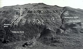
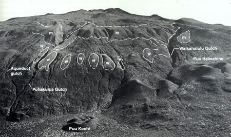
Terminal moraines (m) and glacial till (w)Location Island of Hawaiʻi Nearest city Hilo, Hawaiʻi Area 3,894 acres (1,576 ha) Established 1981 Governing body State Reserve The Mauna Kea Ice Age Natural Area Reserve is a Hawaii state natural reserve that includes the Mauna Kea Adz Quarry, on the southern slope of Mauna Kea on the island of the Hawaiʻi.
Location
The reserve is accessed from the Saddle Road (Hawaii Route 200), about 24 miles (39 km) northwest of Hilo. At 19°41′21″N 155°27′59″W / 19.68917°N 155.46639°W, the Mauna Kea access road leads to the north at about 6,600 feet (2,000 m) elevation. The road was unofficially named for John A. Burns who was Governor of Hawaii when it was built in 1964.[1]:584 The land is part of the Natural Area Reserves System administered by the Hawai'i Department of Land and Natural Resources. The reserve lies above the Onizuka Center for International Astronomy, to the west of the road starting at an elevation of about 10,000 feet (3,000 m) at 19°46′10″N 155°27′47″W / 19.76944°N 155.46306°W. It extends to just below the summit area of Mauna Kea Observatory, at about 13,000 feet (4,000 m) elevation at 19°49′9″N 155°28′28″W / 19.81917°N 155.47444°W. The 3,894-acre (1,576 ha) reserve was established in 1981.[2]
In 1998, the area leased to the Mauna Kea Observatory (called the Kea Science Reserve) was modified to exclude the Ice Age reserve.[3] Another small parcel surrounding the rocky cinder cone called Puʻu Pōhaku at 19°49′31″N 155°29′28″W / 19.82528°N 155.49111°W,[4] contains a rare example of permafrost in the tropics. A 2004 study found the rare wēkiu bug (Nysius wekiuicola) in the reserve.[5]
Mauna Kea Adz QuarryNearest city: Hilo, Hawaii Area: 2 acres (0.81 ha) NRHP Reference#: 66000285 Significant dates Added to NRHP: October 15, 1966[6] Designated NHL: December 29, 1962[7] Quarry
The quarry was used by prehistoric Hawaiians to obtain basalt for stone tools including blades for adzes. Located near the summit of Mauna Kea at an elevation above 12,000 feet (3,700 m) at 19°48′1″N 155°28′4″W / 19.80028°N 155.46778°WCoordinates: 19°48′1″N 155°28′4″W / 19.80028°N 155.46778°W along the Mauna Kea Trail, this is the largest primitive quarry in the world[7]. The archaeological complex also includes religious shrines, trails, rock shelters, and petroglyphs. The Hawaiian language name for the quarry was Keanakākoʻi.[8]
On December 29, 1962, the quarry was added to the list of National Historic Landmarks in Hawaii.[7] On October 15, 1966 it was added to the National Register of Historic Places listings on the island of Hawaii as site 66000285. On May 21, 1981 it was added to the state register as site 10-23-4136.[9]
Lake Waiau is located even further up the trail within the reserve.
References
- ^ Kepa Maly; Onaona Maly (March 30, 2005). Mauna Kea: Ka Piko Kaulana O Ka ʻAina (The famous summit of the land). Kumu Pono Associates. http://www.ulukau.org/elib/cgi-bin/library?c=mauna&l=en.
- ^ "Mauna Kea Ice Age". Hawaii Natural Area Reserves System web site. http://hawaii.gov/dlnr/dofaw/nars/reserves/big-island/maunakeaiceage. Retrieved August 22, 2010.
- ^ "Mauna Kea Science Reserve Master Plan: Education and Research". University of Hawaii. June 16, 2000. http://www.hawaii.edu/maunakea/6_education.pdf. Retrieved August 31, 2010.
- ^ U.S. Geological Survey Geographic Names Information System: Puʻu Pōhaku
- ^ R.A. Englund, et. al.. Hawaii Biological Survey Report on 2004 Wëkiu Bug Sampling. Bernice Pauahi Bishop Museum. http://hbs.bishopmuseum.org/pdf/wekiu2004r.pdf.
- ^ "National Register Information System". National Register of Historic Places. National Park Service. 2007-01-23. http://nrhp.focus.nps.gov/natreg/docs/All_Data.html.
- ^ a b c "Mauna Kea Adz Quarry". National Historic Landmark summary listing. National Park Service. http://tps.cr.nps.gov/nhl/detail.cfm?ResourceId=178&ResourceType=Site. Retrieved 2008-07-04.
- ^ U.S. Geological Survey Geographic Names Information System: Keanakāko‘i
- ^ "National and State Register of Historic Places in Hawaii County". Hawai'i Department of Land and Natural Resources historic preservation division. http://hawaii.gov/dlnr/hpd/register/reghaw.pdf. Retrieved August 22, 2010.
Protected Areas of Hawaii Federal Papahānaumokuākea Marine • World War II Valor in the PacificHakalau Forest • Hanalei • Hawaiian Islands • Huleia • James Campbell • Kakahaia • Kealia Pond • Kilauea Point • Kona Forest • Oahu ForestState Parks,
Monuments
Recreation Areas
and PreservesAkaka Falls State Park · Hapuna Beach State Recreation Area · Kalopa State Recreation Area · Kealakekua Bay State Historical Park · Kohala Historical Sites State Monument · Kona Coast (Kekaha Kai) State Park · Lapakahi State Historical Park · Lava Tree State Monument · MacKenzie State Recreation Area · Manuka State Wayside · Mauna Kea Ice Age Reserve · Mauna Kea State Recreation Area · Old Kona Airport State Recreation Area · Wailoa River State Recreation Area · Wailuku River State ParkKaua‘iMoloka‘iO‘ahuAhupua'a O Kahana State Park · 'Aiea Bay State Recreation Area · Diamond Head State Monument · Hanauma Bay Nature Preserve · He‘eia State Park · ‘Iolani Palace State Monument · Ka'ena Point State Park · Kaka'ako Waterfront Park · Kea'iwa Heiau State Recreation Area · Kewalo Basin · Kukaniloko Birthstones State Monument · La'ie Point State Wayside · Makapu‘u Point State Wayside · Malaekahana State Recreation Area · Nu'uanu Pali State Wayside · Pu'u o Mahuka Heiau State Monument · Pu'u 'Ualaka'a State Wayside · Royal Mausoleum State Monument · Sacred Falls State Park · Sand Island State Recreation Area · Ulu Pō Heiau State Monument · Wa'ahila Ridge State Recreation Area · Wahiawa Freshwater State Recreation AreaCategories:- Protected areas of Hawaii (island)
- Glaciology
Wikimedia Foundation. 2010.