- Kekaha Kai State Park
-
Kekaha Kai State Park 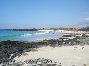
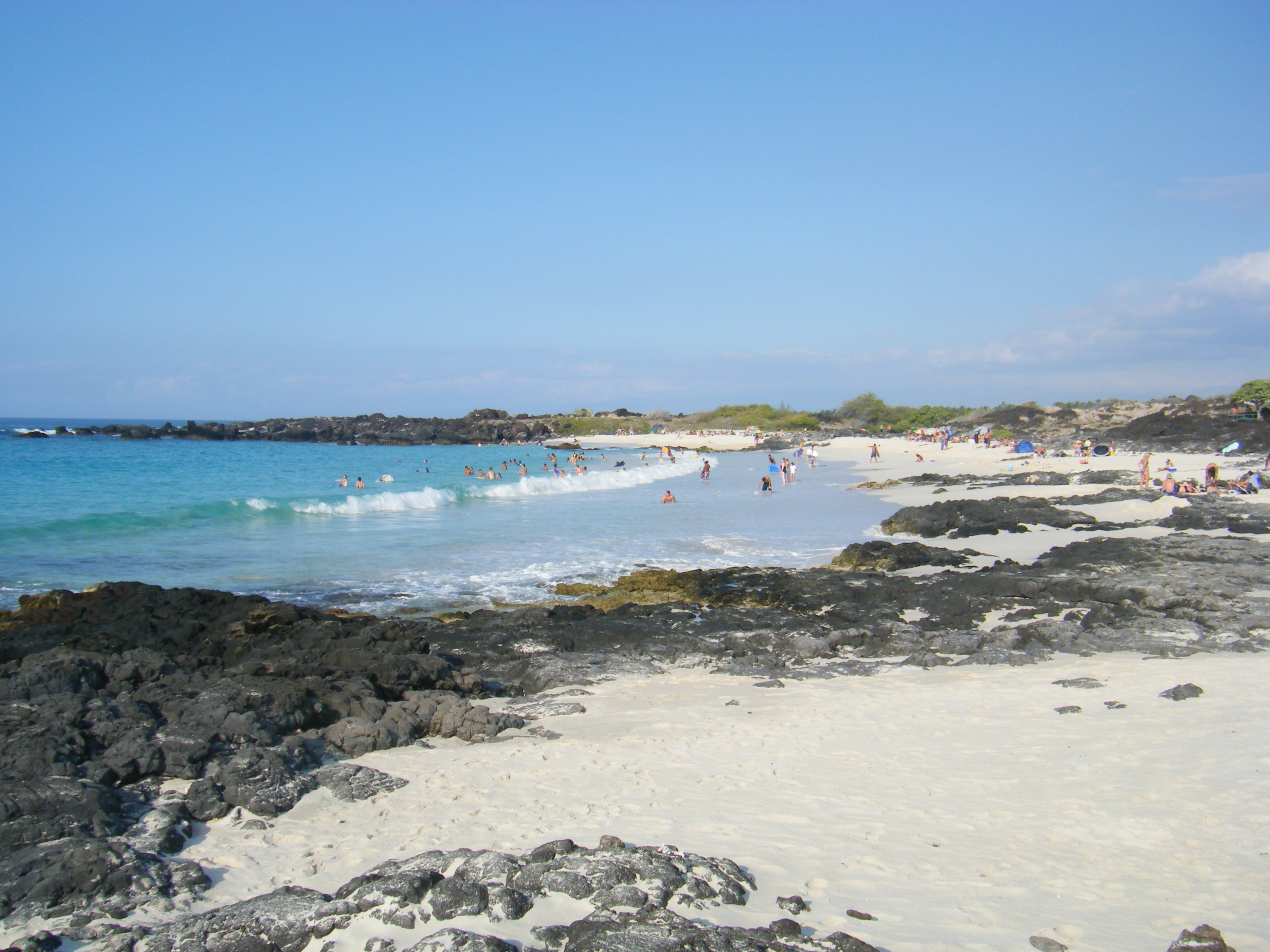
Kua Bay in Kekaha Kai State ParkLocation Hawaii, U.S. Nearest city Kailua-Kona Coordinates 19°47′32″N 156°1′31″W / 19.79222°N 156.02528°W[1] Area 12 acres (0.049 km2) Governing body Hawai'i Department of Land and Natural Resources Official website 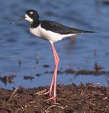 Hawaiian Stilt
Kekaha Kai State Park, formerly known as Kona Coast State Park, is a located along the North Kona coast on the island of Hawaiʻi. It includes Mahaiʻula Beach, Makalawena Beach and Kua Bay. The name comes from ke kaha kai which means "the shore line" in the Hawaiian language.[2]
The northern section of the park is on Maniniʻowali beach at 19°48′36″N 156°2′24″W / 19.81°N 156.04°W, which is normally called Kua Bay since it is easier to pronounce.[3]
The wetland area behind Makalawena beach (the shore of Puʻu Aliʻi Bay)[4] is listed as a National Natural Landmark. It is known as ʻŌpaeʻula Pond (Hawaiian for "red shrimp"), and was the site of an old fishing village of 7 or 8 houses, wiped out in the 1946 tsunami.[5] Its 12 acres (4.9 ha) provide one of the last remaining nesting grounds of the āeʻo (Hawaiian Stilt, Himantopus mexicanus knudseni), the ʻalae keʻokeʻo (Hawaiian Coot, Fulica alai),[6] and the only known breeding area for the ʻaukuʻu (Black-crowned Night Heron, Nycticorax nycticorax hoactli) in Hawaii.[7] It is located at coordinates 19°47′32″N 156°1′31″W / 19.79222°N 156.02528°WCoordinates: 19°47′32″N 156°1′31″W / 19.79222°N 156.02528°W, in the privately-owned area between the two sections of the state park.
The park is open 9:00 am – 7:00 pm daily except Wednesdays.[8] A paved road 2.6 mi (4.2 km) North of Kona International Airport leads to Maniniʻowali (Kua Bay), and an unpaved lava road leads to Mahaiʻula.[9] The Mahaiʻula section has a sandy beach and dune with a picnic area. A 4.5 mi (7.2 km) hike north on the historic coastal trail, Ala Kahakai, connects Mahaiʻula and Kua Bay. A hike to the summit of Puʻu Kuʻili, a 342 ft-high (104 m) cinder cone, offers an excellent view of the coastline. [10]
References
- ^ "Hawaii State Parks". http://www.hawaiistateparks.org/parks/hawaii/Index.cfm?park_id=47. Retrieved 2010-08-23.
- ^ Mary Kawena Pukui and Samuel Hoyt Elbert (2003). "lookup of kahakai ". in Hawaiian Dictionary. Ulukau, the Hawaiian Electronic Library, University of Hawaii Press. http://wehewehe.org/gsdl2.5/cgi-bin/hdict?j=pk&l=en&q=kahakai&d=. Retrieved October 11, 2010.
- ^ John R. K. Clark (2004). "lookup of Kua Bay ". in Hawai'i Place Names: Shores, Beaches, and Surf Sites. Ulukau, the Hawaiian Electronic Library, University of Hawaii Press. http://wehewehe.org/gsdl2.5/cgi-bin/hdict?j=cl&l=en&q=Kua+Bay&d=. Retrieved October 11, 2010.
- ^ Envrironmental Sensitivity Index Map of Makalawena on National Oceanic and Atmospheric Administration web site
- ^ John R. K. Clark, Beaches of the Big Island, University of Hawaii Press, 1985, ISBN 978-0824809768, p.118
- ^ "ʻAlae keʻokeʻo or Hawaiian Coot". Hawaii’s Comprehensive Wildlife Conservation Strategy. State of Hawaiʻi. 2005. http://www.state.hi.us/dlnr/dofaw/cwcs/files/NAAT%20final%20CWCS/Chapters/Terrestrial%20Fact%20Sheets/Waterbirds/hawaiian%20coot%20NAAT%20final2%20!.pdf.
- ^ Makalawena Marsh on National Park Service web site
- ^ Kekaha Kai State Park on the Kulshan.com web site
- ^ Official Coastal Access map on County web site
- ^ Kekaha Kai Page on State Park official web site
Protected Areas of Hawaii Federal Papahānaumokuākea Marine • World War II Valor in the PacificHakalau Forest • Hanalei • Hawaiian Islands • Huleia • James Campbell • Kakahaia • Kealia Pond • Kilauea Point • Kona Forest • Oahu ForestState Parks,
Monuments
Recreation Areas
and PreservesAkaka Falls State Park · Hapuna Beach State Recreation Area · Kalopa State Recreation Area · Kealakekua Bay State Historical Park · Kohala Historical Sites State Monument · Kona Coast (Kekaha Kai) State Park · Lapakahi State Historical Park · Lava Tree State Monument · MacKenzie State Recreation Area · Manuka State Wayside · Mauna Kea Ice Age Reserve · Mauna Kea State Recreation Area · Old Kona Airport State Recreation Area · Wailoa River State Recreation Area · Wailuku River State ParkKaua‘iMoloka‘iO‘ahuAhupua'a O Kahana State Park · 'Aiea Bay State Recreation Area · Diamond Head State Monument · Hanauma Bay Nature Preserve · He‘eia State Park · ‘Iolani Palace State Monument · Ka'ena Point State Park · Kaka'ako Waterfront Park · Kea'iwa Heiau State Recreation Area · Kewalo Basin · Kukaniloko Birthstones State Monument · La'ie Point State Wayside · Makapu‘u Point State Wayside · Malaekahana State Recreation Area · Nu'uanu Pali State Wayside · Pu'u o Mahuka Heiau State Monument · Pu'u 'Ualaka'a State Wayside · Royal Mausoleum State Monument · Sacred Falls State Park · Sand Island State Recreation Area · Ulu Pō Heiau State Monument · Wa'ahila Ridge State Recreation Area · Wahiawa Freshwater State Recreation AreaCategories:- Beaches of Hawaii (island)
- Hawaii state parks
- Protected areas of Hawaii (island)
- Wetlands of Hawaii
- Landforms of Hawaii (island)

Wikimedia Foundation. 2010.