Mahaweli River

Mahaweli River
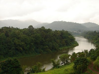
Mahaweli (Mahaweli Ganga)
River
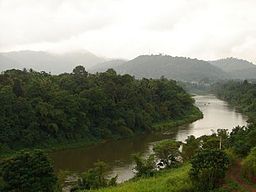
Mahaweli River flowing through Gampola
Country Sri Lanka
Source Central Province
Mouth Bay of Bengal
 - location Trincomalee
 - elevation 0 m (0 ft)
Length 335 km (208 mi)

The Mahaweli River (Sinhala: මහවැලි ගඟ, literally "Great Sandy River"; Tamil: மகாவலி ஆறு [mahawali gangai]),[1] is a 335 km (208 mi) long river, ranking as the longest river in Sri Lanka. Its drainage basin is the largest in the country, and covers almost one-fifth of the total area of the island. The river reaches the Bay of Bengal on the southwestern side of Trincomalee Bay. The bay includes the first of a number submarine canyons, making Trincomalee one of the finest deep-sea harbors in the world.[2] The river and its tributaries are dammed at several locations to allow irrigation in the dry zone, with almost 1,000 km2 (386 sq mi) of land irrigated.[3] Production of hydroelectricity from six dams of the Mahaweli system supplies more than 40% of Sri Lanka's electricity needs. One of the many sources of the river is the Kotmale Oya.[4]

Branches

  • Kotmale Oya
  • Hatton Oya
  • Hulu Ganga
  • Loggal Oya
  • Uma Oya
  • Badulu Oya
  • Amban ganga

See also

  • List of rivers in Sri Lanka

References

  1. ^ Room, Adrian (2001-05-01). Placenames of the World. McFarland & Company. ISBN 0-7864-1814-1. 
  2. ^ Stoddart, David (1996-12-26). Process and Form in Geomorphology. Routledge (UK). ISBN 0-415-10527-7. 
  3. ^ Barry, D. (2001-06-07). Knowledge of the Land. Oxford University Press. ISBN 0-19-829601-0. 
  4. ^ Mahaweli Ganga

Coordinates: 8°28′N 81°14′E / 8.467°N 81.233°E / 8.467; 81.233


Wikimedia Foundation. 2010.

Игры ⚽ Нужна курсовая?

Look at other dictionaries:

  • Mahaweli Reach Hotel Kandy (Kandy) — Mahaweli Reach Hotel Kandy country: Sri Lanka, city: Kandy (River Mahaweli) Mahaweli Reach Hotel Kandy Location The hotel is located on the banks of the Mahaweli River and is just a short drive from Kandy City Centre. Rooms Most of the rooms are… …   International hotels

  • Mahaweli Ganga — The Mahaweli Ganga ( Mahaweli River ; Sinhala mahaväli ganga ) is the longest river in Sri Lanka. It is 335 km (208 mi) long. [cite encyclopedia encyclopedia =Encyclopædia Britannica title = Mahaweli Ganga url =… …   Wikipedia

  • Mahaweli Ganga — ▪ river, Sri Lanka       (Sinhalese: “Great Sandy River”), river, central and eastern Sri Lanka. At 208 mi (335 km) in length, it is Sri Lanka s longest river. It rises on the Hatton Plateau on the western side of the island s hill country, flows …   Universalium

  • Mahaweli — n. river located in Sri Lanka …   English contemporary dictionary

  • Mahanadi River — River Mahanadi River The Mahanadi Name origin: From Sanskrit …   Wikipedia

  • Ghaghara River — Not to be confused with Ghaggar River. Coordinates: 25°45′11″N 84°39′59″E / 25.75306°N 84.66639°E / 25.75306; 84.66639 …   Wikipedia

  • Brahmaputra River — Coordinates: 25°13′24″N 89°41′41″E / 25.22333°N 89.69472°E / 25.22333; 89.69472 …   Wikipedia

  • Chambal River — Coordinates: 26°29′20″N 79°15′10″E / 26.48889°N 79.25278°E / 26.48889; 79.25278 …   Wikipedia

  • Koshi River — Coordinates: 25°24′43″N 87°15′32″E / 25.41194°N 87.25889°E / 25.41194; 87.25889 …   Wikipedia

  • Chenab River — A view of River Chenab near Sialkot A View of Marala He …   Wikipedia

Share the article and excerpts

Direct link
Do a right-click on the link above
and select “Copy Link”