- Gampola
Infobox Settlement
official_name = Gampola
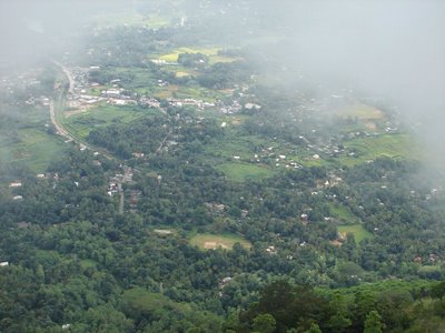
image_caption = A View of Gampola from Ambulawava
image_
map_caption =
pushpin_
subdivision_type = Province
subdivision_name =Central Province, Sri Lanka
leader_title = Mayor
leader_name =
leader_title1 =
leader_name1 =
area_magnitude =
area_total_km2 =
area_total_sq_mi =
area_land_km2 =
area_land_sq_mi =
area_water_km2 =
area_water_sq_mi =
population_as_of =
population_total =
population_metro =
population_density_km2 =
timezone = Sri Lanka Standard Time Zone
utc_offset = +5:30
timezone_DST = Summer time
utc_offset_DST = +6
latd=7 |latm=9 |lats=53 |latNS=N |longd=80 |longm=34 |longs=36 |longEW=E
website =
footnotes =Gampola is a town located near
Kandy in theCentral Province of Sri Lanka. Gampola was made as the capital city of the Island by the King Buwanekabahu the fourth, who ruled for 4 years in mid fourteenth century. The last king of Gampola was King Buwanekabahu the fifth. He ruled the Island for 29 years. A separate city was build in Kotte during this time by a noble known as Alagakkonara.Visitor attractions
Among the remnants of Gampola era, the most famous temples are Lankathilaka, Gadaladeniya and
Embekka Devalaya . The ancient stone scripts (Shila Lekhana) of Lankathilaka temple helps to reveal a considerable amount of vital information regarding the Gampola era. The statue of Buddha of the temple indicates style of south Indian arts. The Ambekka Dewalaya possess a large collection ofWood Carving s, where no other temple inSri Lanka owns such a collection.Demographics
The majority of people in Gampola are Sinhalese
Buddhists while a substantial population ofSri Lankan Moors andIndian Tamils also reside in the city.The city is located in the highlands, which gives it a cold and yet a very enjoyable climate through out the year. Some of the most famous places that are close by to Gampola are the following.
*Ambulava: A hill top tourist spot that houses places of worship of all major religions practised in Sri Lanka. The view of Gampola from here is breath taking. It's thrilling and adventurous to climb the tower that winds up into the foggy skies. Refer to the image depiciting the view of Gampola from Ambulava.
*Kothmale Dam: A few hours drive from here will take you up to the Kothmalae dam and Power generation plant. The view of the dam is really beautiful. One could even drive further up as it's a bueatiful drive up there.Gallery
Maps
* [http://www.liccavi-earth.com/Liccavi/Search.aspx?lat=7.162332&lon=80.57034&zoom=14 Detailed map of Gampola and Sri Lanka]
References
* [http://www.info.lk/srilanka/srilankahistory/gampola_era.htm Gampola Era]
Wikimedia Foundation. 2010.

