- Maha Rat District
-
Maha Rat
มหาราช— Amphoe — Amphoe location in Ayutthaya Province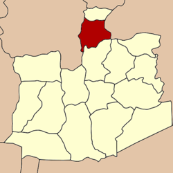
Coordinates: 14°32′3″N 100°31′37″E / 14.53417°N 100.52694°ECoordinates: 14°32′3″N 100°31′37″E / 14.53417°N 100.52694°E Country  Thailand
Province Ayutthaya Seat Hua Phai Tambon 12 Muban 58 Area - Total 120.156 km2 (46.4 sq mi) Population (2010) - Total 23,525 - Density 193.9/km2 (502.2/sq mi) Time zone THA (UTC+7) Postal code 13150 Geocode 1415 Maha Rat (Thai: มหาราช; IPA: [māhǎː râːt]) is a district (amphoe) in the northern part of Ayutthaya Province in Thailand.
Contents
History
Originally the district was named Khwaeng Nakhon Yai. It was converted to an Amphoe in 1914 and changed its name to Maha Rat in 1917.[1]
Geography
Neighboring districts are (from the north clockwise) Ban Phraek of Ayutthaya Province, Don Phut of Saraburi Province, Bang Pahan of Ayutthaya Province, and Pa Mok, Mueang Ang Thong and Chaiyo of Ang Thong Province.
Administration
The district is subdivided into 12 subdistricts tambon, which are further subdivided into 58 villages muban. There are two subdistrict municipalities (thesaban tambon). Maha Rat covers the whole tambon Hua Phai and Maha Rat. Rong Chang covers the whole tambon Nam Tao, Rong Chang, Chao Pluk, and Phit Phian. There are further five Tambon administrative organizations.
No. Name Thai Villages Inh.[2] 1. Hua Phai หัวไผ่ 6 2,156 2. Kathum กะทุ่ม 5 1,272 3. Maha Rat มหาราช 4 1,317 4. Nam Tao น้ำเต้า 4 1,295 5. Bang Na บางนา 5 1,973 6. Rong Chang โรงช้าง 4 1,820 7. Chao Pluk เจ้าปลุก 5 1,571 8. Phit Phian พิตเพียน 7 1,874 9. Ban Na บ้านนา 6 4,053 10. Ban Khwang บ้านขวาง 4 2,052 11. Tha To ท่าตอ 4 2,084 12. Ban Mai บ้านใหม่ 4 2,058 References
- ^ "ประกาศกระทรวงมหาดไทย เรื่อง เปลี่ยนชื่ออำเภอ" (in Thai). Royal Gazette 34 (0 ก): 40–68. 1917-04-29. http://www.ratchakitcha.soc.go.th/DATA/PDF/2460/A/40.PDF.
- ^ "Population statistics 2010". Department of Provincial Administration. http://203.113.86.149/xstat/p5314_01.html.
External links
- amphoe.com (Thai)
Phra Nakhon Si Ayutthaya · Tha Ruea · Nakhon Luang · Bang Sai · Bang Ban · Bang Pa-in · Bang Pahan · Phak Hai · Phachi · Lat Bua Luang · Wang Noi · Sena · Bang Sai · Uthai · Maha Rat · Ban Phraek
Categories:- Amphoe of Ayutthaya
- Central Thailand geography stubs
Wikimedia Foundation. 2010.