- Na Dun District
-
Na Dun
นาดูน— Amphoe — Amphoe location in Maha Sarakham Province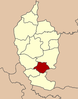
Coordinates: 15°42′50″N 103°13′37″E / 15.71389°N 103.22694°ECoordinates: 15°42′50″N 103°13′37″E / 15.71389°N 103.22694°E Country  Thailand
Province Maha Sarakham Seat Na Dun Tambon Muban Amphoe established Area - Total 248.449 km2 (95.9 sq mi) Population (2005) - Total 36,485 - Density 146.9/km2 (380.5/sq mi) Time zone THA (UTC+7) Postal code 44180 Geocode 4410 Na Dun (Thai: นาดูน) is a district (Amphoe) in the south of Maha Sarakham Province, northeastern Thailand.
Contents
Geography
Neighboring districts are (from the south clockwise) Phayakkhaphum Phisai, Yang Sisurat, Na Chueak and Wapi Pathum of Maha Sarakham Province, and Pathum Rat of Roi Et Province.
History
The area was made a minor district (King Amphoe) on October 1 1969, when the three tambon Na Dun, Nong Phai and Nong Khu were split off from Wapi Pathum district[1]. It was upgraded to a full district on March 25 1979[2].
Administration
The district is subdivided into 9 subdistricts (tambon), which are further subdivided into 94 villages (muban). Na Dun is a township (thesaban tambon) which covers parts of the tambon Na Dun and Phra That. There are further 8 Tambon administrative organizations (TAO).
No. Name Thai name Villages Inh. 1. Na Dun นาดูน 10 4,468 2. Nong Phai หนองไผ่ 8 3,782 3. Nong Khu หนองคู 14 5,512 4. Dong Bang ดงบัง 9 2,692 5. Dong Duan ดงดวน 10 4,071 6. Hua Dong หัวดง 15 5,054 7. Dong Yang ดงยาง 11 4,275 8. Ku Santarat กู่สันตรัตน์ 9 3,715 9. Phra That พระธาตุ 8 2,916 References
- ^ "ประกาศกระทรวงมหาดไทย เรื่อง แบ่งท้องที่ตั้งเป็นกิ่งอำเภอ" (in Thai). Royal Gazette 86 (91 ง): 3118. October 21 1969. http://www.ratchakitcha.soc.go.th/DATA/PDF/2512/D/091/3118.PDF.
- ^ "พระราชกฤษฎีกาตั้งอำเภอหนองกุงศรี อำเภอไทรงาม อำเภอบ้านฝาง อำเภออุบลรัตน์ อำเภอเวียงชัย อำเภอดอยเต่า อำเภอนิคมคำสร้อย อำเภอนาหว้า อำเภอเสิงสาง อำเภอศรีสาคร อำเภอบึงสามพัน อำเภอนาดูน อำเภอค้อวัง อำเภอโพธิ์ชัย อำเภอเมืองสรวง อำเภอปลวกแดง อำเภอยางชุมน้อย อำเภอกาบเชิง อำเภอสุวรรณคูหา และอำเภอกุดข้าวปุ้น พ.ศ. ๒๕๒๒" (in Thai). Royal Gazette 96 (42 ก Special): 19–24. March 25 1979. http://www.ratchakitcha.soc.go.th/DATA/PDF/2522/A/042/19.PDF.
External links
Mueang Maha Sarakham · Kae Dam · Kosum Phisai · Kantharawichai · Chiang Yuen · Borabue · Na Chueak · Phayakkhaphum Phisai · Wapi Pathum · Na Dun · Yang Sisurat · Kut Rang · Chuen Chom
Categories:- Amphoe of Maha Sarakham
- Isan geography stubs

Wikimedia Foundation. 2010.