- Chiang Yuen District
-
Chiang Yuen
เชียงยืน— Amphoe — Amphoe location in Maha Sarakham Province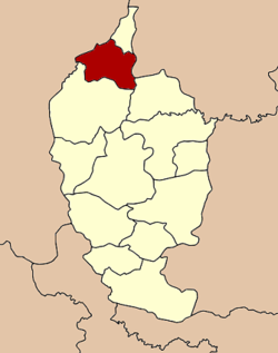
Coordinates: 16°24′29″N 103°6′19″E / 16.40806°N 103.10528°ECoordinates: 16°24′29″N 103°6′19″E / 16.40806°N 103.10528°E Country  Thailand
Province Maha Sarakham Seat Amphoe established 1958 Area - Total 289.0 km2 (111.6 sq mi) Population (2008) - Total 61,704 - Density 214.5/km2 (555.6/sq mi) Time zone THA (UTC+7) Postal code 44160 Geocode 4405 Chiang Yuen (Thai: เชียงยืน) is a district (Amphoe) in the northern part of Maha Sarakham Province, northeastern Thailand.
Contents
Geography
Neighboring districts are (from the north clockwise) Chuen Chom of Maha Sarakham Province, Yang Talat of Kalasin Province, Kantharawichai and Kosum Phisai of Maha Sarakham again, Mueang Khon Kaen and Sam Sung of Khon Kaen Province.
History
On August 16 1958 the minor district (King Amphoe) was split off from Kantharawichai, consisting of the 4 tambon Chiang Yuen, Chuen Chom, Ku Thong and Nong Son.[1] On December 11 1959 it was upgraded to a full district.[2]
Administration
The district is subdivided into 8 subdistricts (tambon), which are further subdivided into 116 villages (muban). Chiang Yuen is a subdistrict municipality (thesaban tambon) which covers parts of the tambon Chiang Yuen. There are further 8 Tambon administrative organizations (TAO).
No. Name Thai Villages Inh.[3] 1. Chiang Yuen เชียงยืน 19 13,758 3. Nong Son หนองซอน 16 6,895 5. Don Ngoen ดอนเงิน 15 7,128 6. Ku Thong กู่ทอง 19 10,155 7. Na Thong นาทอง 11 5,690 8. Suea Thao เสือเฒ่า 16 8,374 11. Phon Thong โพนทอง 12 6,036 12. Lao Bua Ban เหล่าบัวบาน 8 3,668 Missing numbers are the tambon which now form Chuen Chom district.
References
- ^ "ประกาศกระทรวงมหาดไทย เรื่อง ยกฐานะตำบลขึ้นเป็นกิ่งอำเภอ" (in Thai). Royal Gazette 75 (70 ง): 2487. 1958-09-09. http://www.ratchakitcha.soc.go.th/DATA/PDF/2501/D/070/2487.PDF.
- ^ "พระราชกฤษฎีกาตั้งอำเภอชุมพวง อำเภอเชียงยืน อำเภอแก้งคร้อ อำเภอสำโรงทาบ อำเภอคอนสาร อำเภอเซกา อำเภอทุ่งเสลี่ยม อำเภอบ้านด่าน อำเภอขนอม อำเภอบ้านแพรก อำเภอกระทู้ และอำเภอคลองใหญ่ พ.ศ. ๒๕๐๒" (in Thai). Royal Gazette 76 (113 ก ฉบับพิเศษ): 8. 1959-01-10. http://www.ratchakitcha.soc.go.th/DATA/PDF/2502/A/113/8.PDF.
- ^ "Population statistics 2008". Department of Provincial Administration. http://www.dopa.go.th/xstat/p5144_01.html.
External links
- amphoe.com (Thai)
Mueang Maha Sarakham · Kae Dam · Kosum Phisai · Kantharawichai · Chiang Yuen · Borabue · Na Chueak · Phayakkhaphum Phisai · Wapi Pathum · Na Dun · Yang Sisurat · Kut Rang · Chuen Chom
Categories:- Amphoe of Maha Sarakham
- Isan geography stubs

Wikimedia Foundation. 2010.