- Changhan District
-
Changhan
จังหาร— Amphoe — Amphoe location in Roi Et Province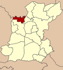
Coordinates: 16°8′18″N 103°36′54″E / 16.13833°N 103.615°ECoordinates: 16°8′18″N 103°36′54″E / 16.13833°N 103.615°E Country  Thailand
Province Roi Et Seat Changhan Tambon Muban Amphoe established Area – Total 165.1 km2 (63.7 sq mi) Population (2005) – Total 47,832 – Density 47.4/km2 (122.8/sq mi) Time zone THA (UTC+7) Postal code 45000 Geocode 4517 Changhan (Thai: จังหาร) is a district (amphoe) in the northwestern part of Roi Et Province, northeastern Thailand.
Contents
Geography
Neighboring districts are (from the east clockwise) Chiang Khwan and Mueang Roi Et of Roi Et Province, Mueang Maha Sarakham of Maha Sarakham Province, Khong Chai and Kamalasai of Kalasin Province.
History
The minor district (King Amphoe) Changhan was established on April 1 1989, when five tambon were split off from Mueang Roi Et district.[1] Tambon Yang Nai was split from tambon Pa Fa in July 1989, and Phakwaen from Muang Lat in July 1990. On September 8 1995 the minor district was upgraded to a full district.[2]
Administration
The district is subdivided into 8 subdistricts (tambon), which are further subdivided into 110 villages (muban). There are no municipal (thesaban) areas, and 8 Tambon administrative organizations (TAO).
No. Name Thai name Villages Inh. 1. Din Dam ดินดำ 17 7,560 2. Pa Fa ปาฝา 12 5,462 3. Muang Lat ม่วงลาด 12 5,682 4. Changhan จังหาร 19 7,089 5. Dong Sing ดงสิงห์ 18 9,458 6. Yang Yai ยางใหญ่ 10 4,228 7. Phak Waen ผักแว่น 13 5,036 8. Saen Chat แสนชาติ 9 3,317 References
- ^ "ประกาศกระทรวงมหาดไทย เรื่อง แบ่งท้องที่อำเภอเมืองร้อยเอ็ด จังหวัดร้อยเอ็ด ตั้งเป็นกิ่งอำเภอจังหาร" (in Thai). Royal Gazette 106 (40 ง): 1886. March 14 1989. http://www.ratchakitcha.soc.go.th/DATA/PDF/2532/D/040/1886.PDF.
- ^ "พระราชกฤษฎีกาตั้งอำเภอด่านมะขามเตี้ย อำเภอแก่งหางแมว อำเภอภักดีชุมพล อำเภอเวียงแก่น อำเภอแม่วาง อำเภอถ้ำพรรณรา อำเภอบ่อเกลือ อำเภอโนนสุวรรณ อำเภอห้วยราช อำเภอแม่ลาน อำเภอบางแก้ว อำเภอป่าพะยอม อำเภอหนองม่วงไข่ อำเภอยางสีสุราช อำเภอจังหาร อำเภอบ้านธิ อำเภอภูสิงห์ อำเภอบางกล่ำ อำเภอวังม่วง และอำเภอนายูง พ.ศ. ๒๕๓๘" (in Thai). Royal Gazette 112 (32 ก): 1–3. August 8 1995. http://www.ratchakitcha.soc.go.th/DATA/PDF/2538/A/032/1.PDF.
External links
Mueang Roi Et · Kaset Wisai · Pathum Rat · Chaturaphak Phiman · Thawat Buri · Phanom Phrai · Phon Thong · Pho Chai · Nong Phok · Selaphum · Suwannaphum · Mueang Suang · Phon Sai · At Samat · Moei Wadi · Si Somdet · Changhan · Chiang Khwan · Nong Hi · Thung Khao Luang
Categories:- Amphoe of Roi Et
- Isan geography stubs

Wikimedia Foundation. 2010.