- Mueang Suang District
-
Mueang Suang
เมืองสรวง— Amphoe — Amphoe location in Roi Et Province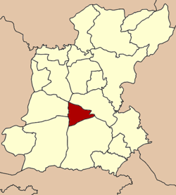
Coordinates: 15°49′25″N 103°43′4″E / 15.82361°N 103.71778°ECoordinates: 15°49′25″N 103°43′4″E / 15.82361°N 103.71778°E Country  Thailand
Province Roi Et Seat Nong Phue Tambon Muban Amphoe established Area - Total 209.4 km2 (80.8 sq mi) Population (2005) - Total 23,751 - Density 113.4/km2 (293.7/sq mi) Time zone THA (UTC+7) Postal code 45220 Geocode 4512 Mueang Suang (Thai: เมืองสรวง) is a district (amphoe) of Roi Et Province, in northeastern Thailand.
Contents
Geography
The district is located in the central part of Roi Et province. Neighboring districts are (from the north clockwise) At Samat, Suwannaphum, Kaset Wisai, Chaturaphak Phiman and Mueang Roi Et (at a single point).
History
Suang was one of the 11 Mueang or city-states who were subordinates of Mueang Roi Et.
The minor district (King Amphoe) was created on March 15 1973, when the three tambon Nong Phue, Nong Hin and Khu Mueang were split off from Suwannaphum district.[1] It was upgraded to a full district on March 25 1979.[2]
Administration
The district is subdivided into 5 subdistricts (tambon), which are further subdivided into 49 villages (muban). Mueang Suang has township (thesaban tambon) status and covers the tambon Mueang Suang and parts of Nong Phue. There are further 3 Tambon administrative organization (TAO).
No. Name Thai name Villages Inh. 1. Nong Phue หนองผือ 9 4,587 2. Nong Hin หนองหิน 10 4,754 3. Khu Mueang คูเมือง 10 5,173 4. Kok Kung กกกุง 11 4,179 5. Mueang Suang เมืองสรวง 9 5,058 References
- ^ "ประกาศกระทรวงมหาดไทย เรื่อง แบ่งท้องที่อำเภอสุวรรณภูมิ จังหวัดร้อยเอ็ด ตั้งเป็นกิ่งอำเภอเมืองสรวง" (in Thai). Royal Gazette 90 (26 ง): 817. March 20 1973. http://www.ratchakitcha.soc.go.th/DATA/PDF/2516/D/026/817.PDF.
- ^ "พระราชกฤษฎีกาตั้งอำเภอหนองกุงศรี อำเภอไทรงาม อำเภอบ้านฝาง อำเภออุบลรัตน์ อำเภอเวียงชัย อำเภอดอยเต่า อำเภอนิคมคำสร้อย อำเภอนาหว้า อำเภอเสิงสาง อำเภอศรีสาคร อำเภอบึงสามพัน อำเภอนาดูน อำเภอค้อวัง อำเภอโพธิ์ชัย อำเภอเมืองสรวง อำเภอปลวกแดง อำเภอยางชุมน้อย อำเภอกาบเชิง อำเภอสุวรรณคูหา และอำเภอกุดข้าวปุ้น พ.ศ. ๒๕๒๒" (in Thai). Royal Gazette 96 (42 ก Special): 19–24. March 25 1979. http://www.ratchakitcha.soc.go.th/DATA/PDF/2522/A/042/19.PDF.
External links
Mueang Roi Et · Kaset Wisai · Pathum Rat · Chaturaphak Phiman · Thawat Buri · Phanom Phrai · Phon Thong · Pho Chai · Nong Phok · Selaphum · Suwannaphum · Mueang Suang · Phon Sai · At Samat · Moei Wadi · Si Somdet · Changhan · Chiang Khwan · Nong Hi · Thung Khao Luang
Categories:- Amphoe of Roi Et

Wikimedia Foundation. 2010.