- Mueang Samut Sakhon District
-
Mueang Samut Sakhon
เมืองสมุทรสาคร— Amphoe — Amphoe location in Samut Sakhon Province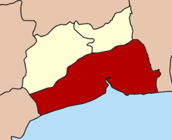
Coordinates: 13°32′54″N 100°16′24″E / 13.54833°N 100.27333°ECoordinates: 13°32′54″N 100°16′24″E / 13.54833°N 100.27333°E Country  Thailand
Province Samut Sakhon Seat Tambon Muban Amphoe established Area – Total 492.04 km2 (190 sq mi) Population (2008) – Total 237,045 – Density 482/km2 (1,248.4/sq mi) Time zone THA (UTC+7) Postal code 74000 Geocode 7401 Mueang Samut Sakhon (Thai: เมืองสมุทรสาคร) is the capital district (Amphoe Mueang) of Samut Sakhon Province, central Thailand.
Contents
History
Mueang Tha Chin name was firstly found in Ayutthaya law that refer to the governor position, Phra Samut Sakhon. The city was managed into the southern cities group that controlled by the Defence ministry. King Mahachakkraphat ordered to establish Mueang Sakhon Buri. King Mongkut (Rama IV) changed the city name to be Samut Sakhon. In 1897 Mueang Samut Sakhon was changed status to be Mueang Samut Sakhon district.
Local Thai people always calls Mueang Samut Sakhon district in the name Maha Chai.
Geography
Neighboring districts are (from the west clockwise) Mueang Samut Songkhram of Samut Songkhram Province, Ban Phaeo and Krathum Baen of Samut Sakhon Province, and Bang Bon and Bang Khun Thian of Bangkok. To the south is the Bay of Bangkok.
Administration
The district is subdivided into 18 subdistricts (tambon), which are further subdivided into 116 villages (muban). Samut Sakhon itself has city status (thesaban nakhon) and covers the three subdistricts Maha Chai, Tha Chalom and Krokkrak. Bang Pla is a subdistrict municipality (thesaban tambon) which covers parts of the same-named subdistrict. Three other subdistricts completely form a subdistrict municipality - Na Di, Bang Ya Phraek and Tha Chin. The non-municipal area is administrated by 12 Tambon administrative organizations (TAO).
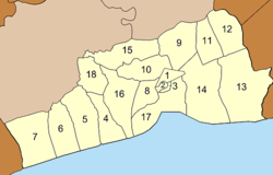
No. Name Thai Villages Inh. 1. Maha Chai มหาชัย - 40,250 2. Tha Chalom ท่าฉลอม - 9,865 3. Krokkrak โกรกกราก - 5,262 4. Ban Bo บ้านบ่อ 9 7,708 5. Bang Tho Rat บางโทรัด 10 8,024 6. Kalong กาหลง 8 4,980 7. Na Khok นาโคก 6 3,743 8. Tha Chin ท่าจีน 7 9,958 9. Na Di นาดี 9 19,667 10. Tha Sai ท่าทราย 8 24,833 11. Khok Krabue คอกกระบือ 6 9,056 12. Bang Nam Chuet บางน้ำจืด 6 11,719 13. Phanthai Norasing พันท้ายนรสิงห์ 8 15,846 14. Khok Kham โคกขาม 10 17,967 15. Ban Ko บ้านเกาะ 8 13,029 16. Bang Krachao บางกระเจ้า 9 8,185 17. Bang Ya Phraek บางหญ้าแพรก 6 23,031 18. Chai Mongkhon ชัยมงคล 6 3,922 External links
- amphoe.com(Thai)
Categories:- Amphoe of Samut Sakhon
- Central Thailand geography stubs


Wikimedia Foundation. 2010.