- Dunderberg Mountain
-
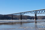
Dunderberg Mountain Elevation 1,086 ft (331 m) [1] Translation Thunder Mountain (Dutch) Location Location Stony Point, Rockland County, New York, USA Range Hudson Highlands Coordinates 41°17′08″N 73°59′11″W / 41.2856495°N 73.9862514°WCoordinates: 41°17′08″N 73°59′11″W / 41.2856495°N 73.9862514°W [2] Topo map USGS Peekskill Climbing Easiest route Hike Dunderberg Mountain stands at the so-called southern gate of the Hudson Highlands where the region's namesake Hudson River enters a dramatic gorge.[3][4][5][6] It rises about 1,086 feet (331 m) from the river's west bank above Jones Point, New York, within Bear Mountain State Park and the town of Stony Point in Rockland County, New York.
Contents
Geography
The bulk of Dunderberg projects into the Hudson River, which describes an arc about its eastern side. Tidal marshes of the river, Snake Hole Creek and Iona Island, lie to the north. On the northwestern side is the abandoned hamlet of Doodletown. At Dunderberg's immediate southern slope is the Hudson River, while to the southwest are outlying neighborhoods of Tomkins Cove, a community or segment of Stony Point.
The mountain as labeled on current U.S. Geological Survey maps and a widely used hiking map, extends about a mile and a half from its easternmost footing on the river at Jones Point. But several summits lying still farther to the west and southwest are evidently part of the Dunderberg formation, or massif, as described by at least some editions of an influential area hiking guidebook.[7] These include Bald Mountain or Bockberg (1,130 feet (344 m)), as well as the Timp (984 feet (300m)), each of which are, however, separately named by the USGS. The Boulderberg, labeled as such on certain maps of historical interest, lies a short distance to the south of the Timp.
As Dunderberg's crest runs inland latitudinally from the river, Timp Brook splits it into northerly and southerly ridges; Bald Mountain lies at the end of the northerly ridge, while the Timp terminates the southerly ridge about two-and a half miles southwest of Jones Point. Timp Brook emerges from a small swamp between the two ridges to flow down steeply to the north around Bald Mountain and thence to the northeast, into the valley known as Doodletown Clove between West Mountain and Dunderberg.
Closely following the upper course of Timp Brook was once the main route into Doodletown from the southwest. A half-mile farther west, an old farm road, later used as a fire road and now a foot-path, also enters Doodletown valley, through a narrow gap known as Timp Pass between the Timp and West Mountain. However, since the late 19th century, the main road up the Hudson (now 9W) has circled around the base of Dunderberg near the river.
History
Revolutionary War
Dunderberg was a landmark for British forces during the American Revolutionary War, as troops moved over a pass to the west of the mountain while marching to attack Forts Clinton and Montgomery in 1777.[8][9][10] In a report to General William Howe several days after the Oct. 6, 1777 attack, the British commander Sir Henry Clinton wrote that at daybreak, 2,100 troops disembarked from vessels at Stony Point:
The Avant Garde of 500 Regulars & 400 Provincials ... began its March to occupy the Pass of Thunder Hill; this Avant Garde after it had passed that Mountain, was to proceed by a detour of seven Miles round the Hill [Bear Mountain], and Debouchée in the Rear of Fort Montgomery, while General Vaughan, with 1200 Men was to continue his March towards Fort Clinton ... Major General Tryon with the Remainder, being the Rear Guard, to leave a Battalion at the Pass of Thunder Hill to open our Communication with the Fleet...[11]
Sir Henry's "Pass of Thunder Hill" apparently stood between what is now called Bald Mountain and the Timp, about a mile southwest of the westerly summit of Dunderberg. It lies about a half-mile east of what is now called Timp Pass. The modern 1777 Trail commemorates Sir Henry's route, and was built in 1974–75 as a joint project of the Rockland County Boy Scouts, the Palisades Interstate Park, the Rockland County Cooperative Extension and the New York-New Jersey Trail Conference. The route was determined by Jack Mead of the Trailside Museum at Bear Mountain from British military records and maps drawn by Major Robert Erskine, Surveyor General of the Continental Army.[12]
Anthony Wayne, in his successful attack on Stony Point in 1779, used a route that entirely avoids the Dunderberg area, passing nearly two miles to the west of the Timp. A contemporary trail commemorates Wayne's route and is mapped by the New York/New Jersey Trail Conference.[5][13][14]
Spiral Railway Corp.
In 1889, the Dunderberg Spiral Railway Corporation formed with the goal of building a hotel at the top of Dunderberg.[15][16] Tourists were to reach the hotel by means of a steam-powered railway. For the descent, the cars would be powered simply by gravity as the 12-mile (19 km) track wound its way back to the base of the mountain, like a roller coaster, affording scenic views of the Hudson and reaching speeds of up to 50 miles per hour (80 km/h).[17]
Directors of the Dunderberg corporation included Henry J. Mumford, who with his brother H.L. Mumford, operated the former Mauch Chunk Railroad of similar design as a successful and well-known tourist attraction during the 1870s in what is now Jim Thorpe, Pennsylvania.[18] The Mauch Chunk Railroad, originally designed for a coal mine, became the inspiration for modern amusement park roller coasters.[19]
Funding for the Dunderberg project ran out in 1891 and the system was never completed; the reasons for the failure remain unclear.
One theory holds that the facility was planned as part of the Columbian Exposition of 1893.[15][20] Verplanck's Point (south of Peekskill) is said to have been considered as a possible location during the planning stage of the Exposition, and it is possible that the funding for the hotel and the railway collapsed after Congress awarded the location to Chicago instead. Although the theory is persistent, no clear documentation has been found to support it.[21]
Today, ruins and some signs of the Spiral Railway construction are still visible. The graded areas can be accessed from the Ramapo-Dunderberg and the Timp-Torne trails, and became somewhat popular for walking following publication of William Howell's two volumes of hiking diaries called "The Hudson Highlands" in 1933 and 1934, and reprinted by "Walking News" in 1982.[22]
Edison Mine
In 1890 Thomas Edison began to establish an iron mine by acquiring nearly 200 acres (0.81 km2) on the north slope of Dunderberg and the base of Bald Mountain. Two years earlier, the inventor had created a method for using electromagnets to separate and refine iron ore.
The remains of Edison's mine lie southeast of Doodletown Reservoir south of the abandoned "Old Turnpike," between the Cornell Mine Trail and the Doodletown Bridle Path. A tailings pile is on the hillside.[23] The land was eventually acquired by the Palisades Interstate Park Commission on December 31, 1938.
Other abandoned iron mines in the immediate vicinity predate Edison's project, and include those on Bald Mountain and West Mountain.[24]
"Upper Level" 9W roadway construction
A 2.44-mile (3.93 km) so-called upper level section of U.S. Route 9W blasted into the side of Dunderberg was opened to traffic in 1931. The lower section of highway had been constructed in 1911 as a 12-foot-wide (3.7 m) roadway. The upper-level project was compared in the 1930s with Storm King Highway and the southeastern approach to Bear Mountain Bridge, two other mountainside highways along the Hudson built in the same era.
For 1.5 miles (2.4 km) the new highway averaged an elevation above the river of between 200 and 300 feet (91 m). The project was undertaken because it reportedly required less excavation and backfilling than that required to widen the lower roadway to four lanes.[25] Funds for the project had been allocated by the state in 1924.[26] Over a period of years the road was temporarily blocked by landslides on a number of occasions.
With the opening of the upper level, the lower highway was to be widened to 20 feet (6.1 m) and carry only northbound traffic, while the upper level, also 20 feet (6.1 m) wide, would carry southbound traffic.[27]
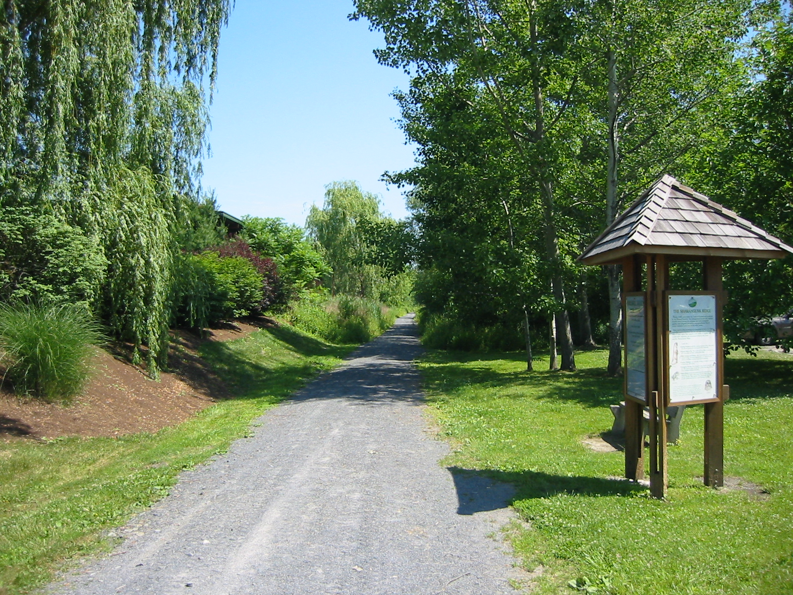
Today the lower roadway appears on maps as a minor secondary road labeled "Old Route 9W." More than a mile of this route is now called the Jones Point Greenway and is used solely for pedestrian and bicycle traffic.[28] The upper roadway is three lanes and additional blasting has evidently been completed in recent years.
Cultural references
- In "The Storm-Ship", Washington Irving portrayed the Dunderberg as home of a malevolent imp, calling up storms against unwary sailors on the Hudson River. "The captains of the river craft talk of a little bulbous-bottomed Dutch goblin, in trunk hose and sugar-loafed hat, with a speaking trumpet in his hand, which they say keeps about the Dunderberg." [29]
- In the Irving story, a priest, while sailing past the Dunderberg is said to have captured the Imp of the Dunderberg, permanently imprisoning the creature within the steeple of the First Reformed Protestant Dutch Church of Kingston, New York (or the Old Dutch Church.)
- The New York-built, Civil War-era ironclad USS Dunderberg took her name from this peak.[30]
See also
- Buckberg
- Popolopen
References
- ^ "Dunderberg Mountain, New York". Peakbagger.com. http://www.peakbagger.com/peak.aspx?pid=7112. Retrieved 2009-02-02.
- ^ "Dunderberg Mountain". Geographic Names Information System, U.S. Geological Survey. http://geonames.usgs.gov/pls/gnispublic/f?p=gnispq:3:::NO::P3_FID:948787. Retrieved 2009-02-02.
- ^ Ward, Christopher (1952). The War of the Revolution. Macmillan. p. 515.
- ^ Adler, Cy (1997). Walking the Hudson, Batt to Bear: From the Battery to Bear Mountain. Green Eagle Press. p. 127. ISBN 9780914018049. http://books.google.com/books?id=py6xfdr6s_MC&pg=PA127&dq.
- ^ a b Mineral Resources of the State of New York. University of the State of New York. 1919. http://books.google.com/books?id=A8jZ4OKtlbAC&pg=RA1-PA10&dq.
- ^ McDonald, George (1992). New York State (Frommer's Comprehensive Travel Guides). Prentice Hall Books. p. 222. ISBN 0133348067.
- ^ Torrey, Raymond H.; Frank Place, Robert Latou Dickinson (1951). New York Walk Book (3rd ed.). American Geographical Society. p. 156. http://books.google.com/books?lr=&client=firefox-a&id=7IUMAAAAYAAJ. Retrieved 2009-02-14.
- ^ Adams, Arthur G (1981). The Hudson: Guidebook to the River. State University of New York Press. p. 148. ISBN 0873954068. http://books.google.com/books?id=4y_3pra6wk4C&pg=PA148&dq.
- ^ Adams, Arthur G (1981). The Hudson: Guidebook to the River. State University of New York Press. p. 169. ISBN 0873954068. http://books.google.com/books?id=4y_3pra6wk4C&pg=PA169&dq.
- ^ Bacon, Edgar M (1902). The Hudson River From Ocean to Source. G.P. Putnam's Sons. p. 338. http://books.google.com/books?id=HcQLAAAAYAAJ&pg=PA338&dq.
- ^ Naval Documents of The American Revolution, Volume 10: American Theatre: October 1, 1777-December 1, 1777. Washington, DC: Government Printing Office. 1996. http://www.revwar75.com/battles/primarydocs/Britishreports.htm.
- ^ Cundell, Tony, The Capture of Forts Clinton and Montgomery and the 1777 Trail.
- ^ Marley, David (1998). Wars of the Americas. Abc-Clio. ISBN 0874368375. http://books.google.com/books?id=rdvp3cGJUZoC&pg=PA315&dq=%22Timp+Pass%22&lr=.
- ^ Studies in Military Geography and Geology. 2003. p. 99. http://books.google.com/books?hl=en&lr=&id=Lq64QTPBqo4C&oi=fnd&pg=PA105&dq=%22Hudson+Highlands%22+and+Stony+Point&ots=KbU3QqZ-Lp&sig=ZC5zRFVHhCSfHKxowNlyIJhgarc#PPA99,M1.
- ^ a b Adams, Arthur G (1981). The Hudson, a Guidebook to the River. State University of New York Press. p. 162. ISBN 0873954068.
- ^ "A Road on Old Dunderberg" (PDF). The New York Times. November 10, 1889. http://query.nytimes.com/mem/archive-free/pdf?_r=1&res=9C01E6D71130E633A25753C1A9679D94689FD7CF.
- ^ Barbara and Wesley Gottlock (2007). New York's Palisades Interstate Park. Arcadia Publishing. pp. 22. ISBN 0738554987. http://books.google.com/books?id=EaQA-hHDIg4C&pg=PA22.
- ^ The Mauch Chunk, Summit Hill & Switchback Railroad
- ^ Sandy, Adam, Roller Coaster History, Ultimate Rollercoaster.
- ^ "Engineers' Task Never Completed". The New York Times. May 4, 1930. http://select.nytimes.com/gst/abstract.html?res=FB0815FF3A5E1B728DDDAD0894DD405B808FF1D3.
- ^ Thomas E. Rinaldi (2006). Hudson Valley Ruins. UPNE. pp. 241. ISBN 1584655984.
- ^ Brennan, Joseph, Diaries of William Thompson Howell, 1997
- ^ "Hiking Doodletown". New York and New Jersey Trail Conference. http://nynjctbotany.org/whudson/doodleto.html.
- ^ New York State Department of Conservation (1940). 1939 Annual Report. pp. 325. http://books.google.com/books?id=LDk4AAAAMAAJ&q=%22dunderberg+mountain%22&dq=%22dunderberg+mountain%22&lr=&pgis=1.
- ^ Scenic Delights at Bear Mountain, June 29, 1930.
- ^ Dickinson, Leon, North-South Route All Paved, September 27, 1931.
- ^ New Highway Planned to Bear Mountain, April 22, 1928.
- ^ Trailways/Shared Use Paths and Greenway Systems, New York State Department of Transportation.
- ^ Washington Irving (1822). Bracebridge Hall; or, The Humorists.
- ^ Erwin Gustav Gudde (1998). California Place Names. University of California Press. pp. 115. ISBN 0520242173.
External links
Rail trails in New York by county List of rail trails in New York Albany 

Allegany Cattaraugus Allegheny River Valley TrailCayuga Columbia Delaware Dutchess Franklin Rutland TrailLivingston Monroe New York Ontario Orange Oswego Putnam Rockland Dunderberg MountainSt. Lawrence Rutland TrailSchenectady Ulster Hudson Valley Rail Trail · Poughkeepsie Bridge · Walden–Wallkill Rail Trail · Wallkill Valley Rail Trail (Rosendale trestle)Westchester Categories:- Rail trails in New York
- Geography of Rockland County, New York
- Bear Mountain State Park
- Ramapos
- Hudson Highlands

Wikimedia Foundation. 2010.