- Dresdner Heide
-
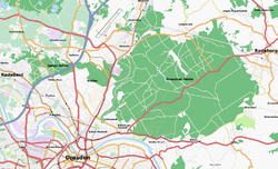 Map of the Dresdner Heide
The Dresdener Heide is a large forest in the city of Dresden. The Heide is the most important recreational area in the city and is also actively forested. Approximately 6.133 Hectare of the Dresdener Heide are designated as a nature preserve, making the Heide one of the largest city forests in Germany by area. Though mainly agricultural areas border the forest in the east, in all other directions the Dresdener Heide is bordered by districts of the city and reaches nearly to the city centre in the southwest.
The forest indicates a transition, both in its geology and in its plant and animal life, between the north German plain and the Mittelgebirge. Except for small areas, the Dresdener Heide is considered part of the western Lusatian Highlands and, consequently, is one of the westernmost parts of the Sudetes. Though the rocky subsoil of the forest was raised during the tectonic formation of the Dresden Basin, the mixed woodland of the Heide is largely characterized by dune-like sand deposits of the Wolstonian Stage and Kansan glaciation. The proximity of the Dresdener Heide to the centre of Dresden lead to its history as an electoral hunting ground, as well as the cultivation and cultural impression of the Heide.
Location
Located in the northeast of the Saxon capital, the main part of the Heide stretches from the city centre to the border of Dresden. The forest is mainly outside the built-up area of Dresden and is largely in the administrative region of Loschwitz. in contrast to the other areas of this administrative area, the 4,836 hectare region isn't considered an urban district, but forms a full-fledged district of the same size. Smaller regions on the edge of the Heide belong to the administrative districts of Neustadt and Klotzsche, as well as to the city of Radeburg. In the south, the main part of the Heide stretches between Loschwitz and the Waldschlösschen district, to the slopes of the Elbe and to Radeberger Vorstadt. The southernmost offshoots even border on the heavily populated Äussere Neustadt. In the west, the forest meets Albertstadt and Klotzsche. In the north, it is bordered by the Weixdorfer districts of Lausa and Friedersdorf as well as by Langebrück and Liegau-Augustusbad. In the east the forest is bordered by the city of Radeberg and its districts of Großerkmannsdorf and Ullersdorf.
The Junge Heide ('Young Heide'), the smaller part, is to the west of the main part of the Heide in the northwest of Dresden. It's bordered in the north by the districts of Wilschdorf and Hellerau, in the east by the Heller and in the south by Trachenberge and Trachau. In the west the Junge Heide meets the Radebeuler districts of Oberlößnitz and Alt-Radebeul, in the northwest, Boxdorf. The part of the Junge Heide in the districts of Hellerberge and Wilschdorf belongs to the administrative district of Klotzsche. The western part of the Junge Heide, on the other hand, is assigned to Trachau. Together with a small area on the edge of the Heide in the south that belongs to Trachenberge, it's in the administrative district of Pieschen. Further areas in the west of the Junge Heide are administered from Moritzburg or Radebeul.
Surrounding landscapes include Lößnitz in the West, the Friedewald and the Moritzburg pond region in the northwest. In the north, the Königsbrück-Ruhlander Heiden and the Seifersdorfer Valley borders the forest in the northeast. The landscape to the southeast is the Schönfeld Upland. On the southern border of the Heide, the forest segues into the park and garden landscape of the Dresden Elbe valley.
History of the Forest
Originally, the Dresdener Heide was part of the expansive, continuous border forest between the Sorbian regions of Nisan and Milska. It was out of this forest that the Mark of Meißen and Upper Lusatia developed. Originally, the Dresdener Heide began in the city centre of Dresden and stretched seamlessly to the Lößnitz as well as to Kaditz, in the form of the Kaditz Forest. Archaeological discoveries, such as the bronze age burial grounds and late stone age Corded Ware pottery give evidence of early settlements in this area. The settlement of the region reduced the area of the forest with time. As part of the German eastward settlement in the twelfth and thirteenth centuries, efforts to clear the forest reduced it to something close to its current size, though the Dresdener Heide still stretched into the centre of Dresden, and the Junge Heide wasn't yet a separate forest.
After 1372, the Dresdener Heide was sovereign property assigned to the office of Radeberg, servicing the court of Saxony as a vast hunting territory from the Middle Ages to the First World War. The court in Dresden could 'hunt' its way from Dresden to the hunting retreat Schloss Moritzburg. Evidence of the Heide's hunting history are the four so-called Saugärten ('Swine gardens,' used in the hunt to hold captured wild boar, until it could be released to be hunted). Farmers have also used parts of the Heide, such as the two meadows, for agriculture. In the light, sandy soil, agriculture didn't last long and fields were often actively reforested or reclaimed by the forest itself. Since 1484 the Heide was administered by the Dresden Forest Office. The forest was heavily damaged in the Thirty Years' War as enemy troops burned parts of the forest and plundered surrounding villages. The Seven Years' War also brought great losses of wood to the Prussian occupiers. In 1831 the Heide became a possession of the Saxon State but remained hunting grounds of the sovereign.
In the beginning of the nineteenth century the Heide had an area of over 70 square kilometres, roughly fifty percent more than now. It still reached in the city centre across the Bischofsweg. The Förstereistraße ('Forestry Street') in Neustadt is named after a forester's lodge that existed there near the forest. Then the Heide was reduced by 10 square kilometres for military reasons. Large areas were deforested after 1827 to create a training ground for the Saxon army, resulting in the existence of the Heller. After 1873 barracks were constructed in the new military district in Albertstadt, significantly reducing the southwestern area of the Heide. Adjacent areas of the forest were also inaccessible because they were behind firing ranges. In the late nineteenth century, the former suburbs of Dresden began to grow. The Radeberger Vorstadt (city suburb in the direction of Radeberg) stretched further and further into the forest. Within a few years, people pushed the Heide back out of the city centre by two kilometres. Klotzsche also grew into a city, in part at the expense of the forest. In Radebeul-Ost, Bad Weißer Hirsch, Klotzsche-Königswald and the Radeberger Vorstadt more of the Heide was converted into 'Forest Parks.' In the beginning of the twentieth century, the responsible authorities required compensatory plantings to counter smaller clearings of the Heide. This resulted in the planting of a small forest near Biegau in 1910.
The separation between the Dresdener and Junge Heide was brought about by the development of transportation corridors such as Radeburger and Königsbrücker Streets as well as the Saxon-Silesian railway and, finally, the present Autobahn A4. In the Third Reich, planned highway construction affected the northeast part of the forest. The plan was for a continuation of the present Autobahn 13, resulting in a Berlin-Dresden-Prague connection. Some of the deforestation between Radeberg and Heidemühle was completed, but construction didn't begin in the Second World War. The plans were later discarded and, in 2000, the same connection was built but with a completely different route and without affecting the Heide in any way. In the 1930s there were plans for a continuation of the now-decommissioned rail line between Dürröhrsdorf and Weißig, along the Prießnitz valley across the Heide. This, too, remained in the planning stage and, since then, the forest hasn't been reduced by large constructions.
Since its incorporation into the city on the fourth of March, 1949, the Dresdener Heide belongs to Dresden. Declared a special forest and recreation area in 1967, it has been a protected landscape since 1969. Due to forestry however, almost no area of the Heide can be considered old growth forest. There are still inaccessible parts of the Heide, a result of the former military use or of the construction of transportation buildings.
See also
Categories:- Geography of Dresden
- Visitor attractions in Dresden
- Nature reserves in Germany
- Protected areas of Saxony
- Forests and woodlands of Saxony

Wikimedia Foundation. 2010.