- Doi Inthanon National Park
-
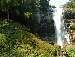
 The Wachirathan waterfall within the national park, on Doi Inthanon, the highest mountain in Thailand.
 Cethosia biblis, Doi Inthanon National Park.
Doi Inthanon National Park (Thai: ดอยอินทนนท์; Pronunciation; nickname: "the roof of Thailand") is located in Mae Chaem District, Chiang Mai Province, northern Thailand.[1] It includes Doi Inthanon, the country's highest mountain. Established in 1972, is 482 square kilometres (186 sq mi) in size.[2]
Geography
The park is situated approximately 60 kilometres (37 mi) from Chiang Mai. It includes Karen and Meo Hmong villages of about 4,500 people.[3] Its elevation range between 800–2,565 metres (2,600–8,415 ft). There are a number of waterfalls such as the Mae Klang Falls, Wachiratan Falls, Siriphum Falls, and Mae Ya Falls.[4] The park has varied climatic and ecological different sections.
Flora and fauna
Its flora includes evergreen cloud forest, sphagnum bog, and deciduous dipterocarp forest.[2] There are some relict pines.[4] With 383 avifauna species,[5] it ranks second in number of bird species within Thailand's national parks.
References
- ^ Spooner, Andrew; Borrowman, Hana; Baldwin, William (February 1, 2007). Footprint Thailand. Footprint Travel Guides. pp. 704–. ISBN 978-1-904777-94-6. http://books.google.com/books?id=z9RsdHajfucC&pg=PA704. Retrieved October 1, 2011.
- ^ a b Reed Business Information (November 18, 1989). New Scientist. Reed Business Information. pp. 43–. ISSN 02624079. http://books.google.com/books?id=_fyqegiv0lEC&pg=PA43. Retrieved October 1, 2011.
- ^ Zeppel, Heather (2006). Indigenous ecotourism: sustainable development and management. CABI. pp. 237–. ISBN 978-1-84593-124-7. http://books.google.com/books?id=noFNSuofi6IC&pg=PA237. Retrieved October 1, 2011.
- ^ a b Eliot, Joshua; Bickersteth, Jane (March 13, 2003). Thailand handbook. Footprint Travel Guides. pp. 330–. ISBN 978-1-903471-54-8. http://books.google.com/books?id=lg1t7IhJwsEC&pg=PA330. Retrieved October 1, 2011.
- ^ Poultney, Trevor (January 1, 2003). Environments: Asia Pacific. Curriculum Press. pp. 22–. ISBN 978-1-86366-567-4. http://books.google.com/books?id=cDX15HYzIloC&pg=PA22. Retrieved October 1, 2011.
National parks, forest parks and wetlands in Thailand National parks Budo-Su-ngai Padi · Chiang Dao · Doi Inthanon · Erawan · Hat Khanom - Mu Ko Thale Tai · Kaeng Chet Khwae · Kaeng Krachan · Kaeng Krung · Kaeng Tana · Khao Phra Wihan · Khao Luang · Khao Sok · Khao Yai · Khlong Lan · Khlong Phanom · Khlong Wang Chao · Kui Buri · Mae Yom · Mae Wong · Nam Nao · Namtok Chat Trakan · Pa Hin Ngam · Pha Taem · Phu Chong-Na Yoi · Phu Hin Rong Kla · Phu Kradueng · Phu Toei · Phu Wiang · Ramkhamhaeng · Salawin · Si Phang-nga · Si Satchanalai · Tai Rom Yen · Thale Ban · Than Sadet-Ko Pha-Ngan · Thap Lan · Thung Salaeng Luang
Marine national parks Ao Phang Nga (Phang Nga Bay) · Hat Chao Mai · Hat Nai Yang · Hat Nopharat Thara-Mu Ko Phi Phi · Khao Laem Ya-Mu Ko Samet · Khao Sam Roi Yot · Laem Son · Mu Ko Ang Thong · Mu Ko Chang · Mu Ko Lanta · Mu Ko Phetra · Mu Ko Similan · Mu Ko Surin · Tarutao
Forest parks Wetlands Categories:- National parks of Thailand
- Protected areas established in 1972
- Chiang Mai Province
Wikimedia Foundation. 2010.
