Don Hoi Lot

Don Hoi Lot
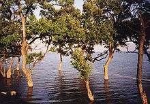
Mangrove trees near Don Nai

Don Hoi Lot (Thai: ดอนหอยหลอด) is a sandbar off the coast of Samut Songkhram Province at the northwestern tip of the Bay of Bangkok. The sediments of the Mae Klong River together sediments from the sea form a system of mudflats, which is settled by the Razor Clam shell (Solen regularis), which also gave the site its Thai name. The site has the largest population of this shell species, which is endemic to the northern Gulf of Thailand. Also 18 bird and 42 invertebrate species are recorded at the mudflats and the adjoining coastal mangrove forests.

The mudflat Don Nai is located directly at the coast and accessible by car. At Chu Chi village several sea food restaurants offer the local shells; also the highly-revered shrine of Prince Chumphon Khet-Udomsak attracts Thai visitors.

Since July 5 2001 the site is registered as Ramsar site number 1099.

Sources

Coordinates: 13°22′N 100°2′E / 13.367°N 100.033°E / 13.367; 100.033


Wikimedia Foundation. 2010.

Игры ⚽ Нужно решить контрольную?

Look at other dictionaries:

  • Samut Songkhram Province — Infobox Thai Province name = Samut Songkhram thai = สมุทรสงคราม capital = Samut Songkhram town area = 416.7 arearank = 76th population = 204.177 population as of = 2000 populationrank = 75th density = 490 densityrank = 5th isocode = TH 75… …   Wikipedia

  • Mueang Samut Songkhram District — Mueang Samut Songkhram เมืองสมุทรสงคราม   Amphoe   Amphoe location in Samut Songkhram Province …   Wikipedia

  • List of Thailand-related articles — Thailand, known officially as the Kingdom of Thailand (IPAEng|ˈtaɪlænd, th. ราชอาณาจักรไทย, IPA2|râːtɕʰa ʔaːnaːtɕɑ #x0300;k tʰɑj) is a country in Southeast Asia. To its east lie Laos and Cambodia; to its south, the Gulf of Thailand and Malaysia;… …   Wikipedia

  • List of national parks of Thailand — Haeo Suwat waterfall in Khao Yai National Park, Thailand s first national park, designated in 1961. National parks in Thailand (Thai: อุทยานแห่งชาติทางบก) are defined as an area of least ten square kilometres that contains natural resources of… …   Wikipedia

  • Chiang Dao National Park — IUCN Category II (National Park) Location Chiang Mai Province, Thailand Coordinates …   Wikipedia

  • Surin Islands — Surin Island National Park, Thailand The Surin Islands (Thai: หมู่เกาะสุรินทร์, Thai pronunciation: [mùː kɔ̀ʔ sùʔrin]) is an archipelago of five islands of the Andaman Sea, located 55 km from the Thai mainland …   Wikipedia

  • Amphoe Mueang Samut Songkhram — Infobox Amphoe name=Mueang Samut Songkhram thai=เมืองสมุทรสงคราม province=Samut Songkhram capital=Mae Klong coordinates=coord|13|24|50|N|100|0|12|E|type:adm2nd region:TH area=169.057 population=103,268 population as of=2005 density=610.8 postal… …   Wikipedia

  • Mu Ko Phetra National Park — IUCN Category II (National Park) View of Ko Phetra from Ko Lao Liang Nuea …   Wikipedia

  • Similan Islands — The Similan Islands (Thai: หมู่เกาะสิมิลัน, Thai pronunciation: [mùː kɔ̀ʔ si.mi.lan], Malay: Pulau Sembilan سمبيلن ڤولاو) is a group of islands in the Andaman Sea off the coast of Phang Nga Province, southern …   Wikipedia

  • Mu Ko Lanta National Park — IUCN Category II (National Park) Koh Lanta Beach …   Wikipedia

Share the article and excerpts

Direct link
Do a right-click on the link above
and select “Copy Link”