- Cottondale, Mississippi
-
Cottondale, Mississippi — Ghost town — 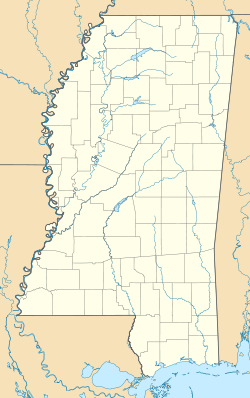
 Cottondale, Mississippi
Coordinates: 33°41′24″N 90°32′34″W / 33.69°N 90.54278°WCoordinates: 33°41′24″N 90°32′34″W / 33.69°N 90.54278°W Country United States State Mississippi County Sunflower Elevation 121 ft (37 m) Time zone Central (CST) (UTC-6) – Summer (DST) CDT (UTC-5) ZIP code 38771 Area code(s) 662 GNIS feature ID 668853[1] Cottondale is an ghost town[citation needed] located in Sunflower County, Mississippi. Cottondale is located on U.S. Highway 49W and is approximately 2 miles (3.2 km) south of Ruleville and approximately 2.6 miles (4.2 km) north of Doddsville.
References
Municipalities and communities of Sunflower County, Mississippi Cities 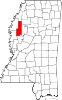
Towns Unincorporated
communitiesBaird | Baltzer | Blaine | Boyer | Caile | Dockery | Dwyer | Fairview | Heathman | Holly Ridge | Kinlock | Linn | Parchman | Rome | Roundaway | Steiner | Stephensville
Ghost towns Cottondale | Inwood
Footnotes ‡This populated place also has portions in an adjacent county or counties
Categories:- Geography of Sunflower County, Mississippi
- Unincorporated communities in Mississippi
- Mississippi geography stubs


Wikimedia Foundation. 2010.