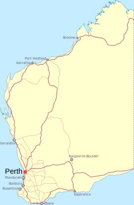
- Dunsborough, Western Australia
-
Dunsborough
Western AustraliaPopulation: 3,371 (2006 Census)[1] Established: 1879 Postcode: 6281 Elevation: 10 m (33 ft) Location: - 255 km (158 mi) South West of Perth
- 23 km (14 mi) West of Busselton
- 37 km (23 mi) North of Margaret River
LGA: Shire of Busselton State District: Vasse Federal Division: Forrest Coordinates: 33°37′16″S 115°05′36″E / 33.621°S 115.0934°E
Dunsborough is a coastal town in the South West of Western Australia, 254 kilometres (158 mi) south of Perth on the shores of Geographe Bay.
Dunsborough is a popular tourist destination for Western Australians; in 1999 it was voted the state's best tourist destination. During the last decade the town has grown quickly and become quite affluent; consequently cafes have popped up everywhere. The town is a common destination for annual school leavers in WA, the other frequent choice being Rottnest Island.
Contents
History
The town is named after the nearby Dunn Bay, which was named after Captain Richard Dalling Dunn under whom Governor James Stirling had served in the Hibernia and the Armide in 1810-11. Land for a townsite was set aside here in the late 1830s, and there is a recorded whale fishery at "Dunsbro" in 1850. When Dunsborough first appeared on a map in 1839 it was spelt "Dunnsbro" but the extra "n" seems to have disappeared by 1850, and the spelling of "bro" was amended to "borough" when the name was gazetted in 1879.[2]
Present day
Dunsborough is the older settlement near to Cape Naturaliste while the closer settlement Bunkers Bay is much more recent - having evolved from a group of holiday shacks to the local Millionaires Row community.
Transport
Dunsborough is serviced by Busseltons public bus service route 903 run by South West Coach Lines. South west coach lines and Transwa coach services also run service to Dunsbrough for connections to other south west towns and Perth.
Annual events
- Meelup Hill Climb - motorcar rally
- Anaconda Adventure Race
- Dunsborough Arts Festival
See also
References
- ^ Australian Bureau of Statistics (25 October 2007). "Community Profile Series : Dunsborough (Urban Centre/Locality)". 2006 Census of Population and Housing. http://www.censusdata.abs.gov.au/ABSNavigation/prenav/ProductSelect?newproducttype=Community+Profiles&collection=Census&period=2006&areacode=UCL508000&breadcrumb=LP¤taction=201&action=401. Retrieved 2008-09-20.
- ^ Western Australian Land Information Authority. "History of country town names". http://www.landgate.wa.gov.au/corporate.nsf/web/History+of+country+town+names. Retrieved 2007-06-08.
Further reading
- Jack, J. and Robertson, R. (editors) (2001) Cape Of Contrasts/Stories of Cape Naturaliste, Western Australia Dunsborough ISBN 0-9579601-0-7
Towns in the South West region of Western Australia Major centres Towns Acton Park · Alexandra Bridge · Allanson · Augusta · Balingup · Benger · Binningup · Boyanup · Boyup Brook · Bramley · Bridgetown · Brookhampton · Brunswick Jn. · Burekup · Capel · Carbunup River · Chowerup · Cookernup · Cowaramup · Cundinup · Dardanup · Deanmill · Dingup · Dinninup · Donnelly River · Donnybrook · Elgin · Ferguson · Forest Grove · Forrest Beach · Gnarabup · Gracetown · Greenbushes · Hester · Jardee · Jarrahwood · Karridale · Kirup · Kudardup · Kulikup · Ludlow · Mayanup · Metricup · Mullalyup · Myalup · Nannup · Nornalup · Northcliffe · Nyamup · Pemberton · Peppermint Grove Beach · Prevelly · Quindalup · Quinninup · Roelands · Rosa Brook · Shotts · Stratham · Uduc · Vasse · Walpole · Waterloo · Wilga · Windy Harbour · Witchcliffe · Wokalup · Wonnerup · Worsley · Yallingup · Yarloop · Yornup
Categories:- Towns in Western Australia
- South West (Western Australia)
- Coastal towns in Western Australia
Wikimedia Foundation. 2010.

