Cooley Mountains

Cooley Mountains
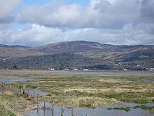
Cooley Mountains from the south

The Cooley Mountains are located on the Cooley Peninsula in northeast County Louth in Ireland. They consist of two ridges oriented northwest to southeast, separated by the valley of Glenmore with the Big River running through it.

Slieve Foy at 588 metres is the highest peak on the eastern ridge and the highest peak in County Louth. The ridge rises at The Foxes Rock (404m), and runs for roughly 6 km in a southeasterly direction to the town of Carlingford, County Louth. The entire ridge is known as Carlingford Mountain. Two other mountains in the Cooley mountains are locally known as Maeves Gap and Paddys top. Maeves Gap received its name from the Legendary Queen Maeve who led her Armies through this area.

The highest hill in the eastern ridge is Clermont Carn (510 m). Also the mythological home of Hurling as told in the Táin Bó Cúailnge, when Setanta traveled through these mountains hitting his sliator before him on his way to Emain Macha, this feat is re-enacted every year in the All-Ireland Poc Fada Championship which takes place on Annaverna Mountain.

Coordinates: 54°03′11.7″N 6°16′30″W / 54.05325°N 6.275°W / 54.05325; -6.275


Wikimedia Foundation. 2010.

Игры ⚽ Поможем решить контрольную работу

Look at other dictionaries:

  • Cooley Distillery — Founded 1987 Headquarters County Louth, Ireland Products Irish Whiskey Website …   Wikipedia

  • Cooley Peninsula — Coordinates: 54°2′4″N 6°13′36″W / 54.03444°N 6.22667°W / 54.03444; 6.22667 …   Wikipedia

  • Wicklow Mountains — Coordinates: 53°04′52″N 6°23′24″W / 53.08111°N 6.39°W / 53.08111; 6.39 …   Wikipedia

  • Clermont Carn — Clermont Carn, variously spelt as Clermont Cairn , Clairmont Carn/Cairn or other variations is a 510m [1] high peak in the Cooley Mountains in County Louth which is also home to a main RTÉ Network Limited transmission site[2] …   Wikipedia

  • Rostrevor — For the place in Adelaide, South Australia, see Rostrevor, South Australia.Rostrevor (in Irish: Ros Treabhair , ie Trevor’s Wood, also Caisleán Ruairí , ie Rory s Castle) is a village in County Down, Northern Ireland. It lies on Carlingford Lough …   Wikipedia

  • Ó hAnluain — Ó Anluain The Ó Hanlon , Lord of Orior Ancestral house Uí Nialláin (Síl Cernaich) Titles kings of Uí Nialláin roidama of Ireland (w/ others) lords of Airghialla The O’Hanlon, lord of Orior Rex et Duxes, Airthir Lord of Nialláin Baron of Orior… …   Wikipedia

  • Montpelier Hill — Hell Fire Club Dawn at the Hell Fire Club on Montpelier Hill, Dublin …   Wikipedia

  • Mullaghcleevaun — Mullach Cliabháin Mullaghcleevaun summit and Lough Cleevaun …   Wikipedia

  • Mount Leinster — Stua Laighean Mount Leinster with its TV transmitter Elevation …   Wikipedia

  • Djouce — Dioghais Northern slope of Djouce Elevation …   Wikipedia

Share the article and excerpts

Direct link
Do a right-click on the link above
and select “Copy Link”