- Oldpark (District Electoral Area)
-
Oldpark
District Electoral Area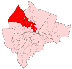
Map showing Oldpark wards within BelfastPopulation (2008 Estimate) District Belfast City Council County County Antrim Country Northern Ireland Sovereign state United Kingdom EU Parliament Northern Ireland UK Parliament Belfast North NI Assembly Belfast North List of places: UK • Northern Ireland • Antrim Oldpark is one of the nine district electoral areas (DEA) in Belfast, Northern Ireland. Located in the west of the city, the district elects six members to Belfast City Council and contains the wards of Ardoyne; Ballysillan; Cliftonville; Legoniel; New Lodge and Water Works. Oldpark forms part of the Belfast North constituency for the Northern Ireland Assembly and UK Parliament.
Contents
History
The DEA was created for the 1985 local elections. Legoniel, Ballysillan and Ardoyne wards had previously been part of Area E, New Lodge and the southern half of the Waterworks ward had been in Area G, while Cliftonville and the northern half of Waterworks ward had been in Area H.
Wards
Map Ward Population
(2008 Estimate)Population
(2001 Census)Catholic Protestant Other Area Density NI Assembly UK Parliament Ref 1 Ardoyne 6,106 6,602 96.4% 3.2% 0.4% 0.58 km2 11,383 /km2 Belfast North Belfast North [1] 2 Ballysillan 5,854 6,020 4.4% 90.7% 4.9% 1.11 km2 5,423 /km2 Belfast North Belfast North [2] 3 Cliftonville 5,093 5,421 68.3% 29.2% 2.5% 1.18 km2 4,594 /km2 Belfast North Belfast North [3] 4 Legoniel 5,808 5,528 37.7% 59.2% 3.1% 8.82 km2 627 /km2 Belfast North Belfast North [4] 5 New Lodge 4,988 5,224 97.3% 2.2% 0.5% 0.72 km2 7,256 /km2 Belfast North Belfast North [5] 6 Water Works 5,949 6,305 90.7% 6.7% 2.6% 1.27 km2 4,965 /km2 Belfast North Belfast North [6] Oldpark 33,798 35,100 66.1% 31.5% 2.4% 13.68 km2 2,566 /km2 Belfast North Belfast North Councillors
Election Councillor
(Party)Councillor
(Party)Councillor
(Party)Councillor
(Party)Councillor
(Party)Councillor
(Party)2011 Gareth McKee
(DUP)Ian Crozier
(DUP)Nichola Mallon
(SDLP)Daniel Lavery
(Sinn Féin)Conor Maskey
(Sinn Féin)Gerard McCabe
(Sinn Féin)2005 Fred Cobain
(UUP)Nelson McCausland
(DUP)Alban Maginness
(SDLP)Margaret McCleneghan
(Sinn Féin)Carál Ní Chuilín
(Sinn Féin)2001 Billy Hutchinson
(PUP)Martin Morgan
(SDLP)Gerard Brophy
(Sinn Féin)Eoin O'Broin
(Sinn Féin)1997 Fred Proctor
(UUP)Paddy McManus
(Sinn Féin)Mick Conlon
(Sinn Féin)Bobby Lavery
(Sinn Féin)1993 Fred Rodgers
(UUP)Joe Austin
(Sinn Féin)1989 William Gault
(UUP)Brian Feeney
(SDLP)Gerard McGuigan
(Sinn Féin)Seamus Lynch
(Workers' Party)1985 P M Lunn
(DUP)Bobby Lavery
(Sinn Féin)2011 Elections
Belfast City Council elections, 2011[7] Party Candidate 1st Pref Democratic Unionist Ian Crozier 1,770 Sinn Féin Conor Maskey 1,573 Sinn Féin Gerard McCabe 1,492 Sinn Féin Daniel Lavery 1,370 SDLP Nichola Mallon 1,184 Sinn Féin Mary Clarke 1,180 Democratic Unionist Gareth McKee 917 Ulster Unionist Fred Rodgers 540 Irish Republican Socialist Paul Little 379 Alliance James McClure 303 Independent Martin McAuley 146 Turnout 10,584 Democratic Unionist gain from Ulster Unionist See also
- Belfast City Council
- Electoral wards of Belfast
- Local government in Northern Ireland
- Members of Belfast City Council
References
- ^ "Ward Information for Ardoyne ward 95GG02". NISRA. http://www.ninis.nisra.gov.uk/mapxtreme/pf_report.asp?sLevel=WARD&sID=95GG02&sName=Ardoyne. Retrieved 13 June 2011.
- ^ "Ward Information for Ballysillan ward 95GG06". NISRA. http://www.ninis.nisra.gov.uk/mapxtreme/pf_report.asp?sLevel=WARD&sID=95GG06&sName=Ballysillan. Retrieved 13 June 2011.
- ^ "Ward Information for Cliftonville ward 95GG17". NISRA. http://www.ninis.nisra.gov.uk/mapxtreme/pf_report.asp?sLevel=WARD&sID=95GG17&sName=Cliftonville. Retrieved 13 June 2011.
- ^ "Ward Information for Legoniel ward 95GG32". NISRA. http://www.ninis.nisra.gov.uk/mapxtreme/pf_report.asp?sLevel=WARD&sID=95GG32&sName=Legoniel. Retrieved 13 June 2011.
- ^ "Ward Information for New Lodge ward 95GG35". NISRA. http://www.ninis.nisra.gov.uk/mapxtreme/pf_report.asp?sLevel=WARD&sID=95GG35&sName=New%20Lodge. Retrieved 13 June 2011.
- ^ "Ward Information for Water Works ward 95GG47". NISRA. http://www.ninis.nisra.gov.uk/mapxtreme/pf_report.asp?sLevel=WARD&sID=95GG47&sName=Water%20Works. Retrieved 13 June 2011.
- ^ Elections 2011: Oldpark, Belfast City Council

Antrim Borough Council Castle
Newtownabbey Borough CouncilCastle Antrim Borough Council 
Castle  Oldpark

Court Court
Lower FallsLower Falls Belfast City Council General 
People District Electoral Areas Amenities Parks and gardens Cemeteries Elections See also: Local government in Northern Ireland • Category Categories:- Electoral wards of Belfast


Wikimedia Foundation. 2010.