- Court (District Electoral Area)
-
Court
District Electoral Area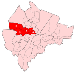
Map showing Castle wards within BelfastPopulation (2008 Estimate) District Belfast City Council County County Antrim Country Northern Ireland Sovereign state United Kingdom EU Parliament Northern Ireland UK Parliament Belfast North
Belfast WestNI Assembly Belfast North
Belfast WestList of places: UK • Northern Ireland • Antrim Court is one of the nine district electoral areas (DEA) in Belfast, Northern Ireland. Located in the west of the city, the district elects five members to Belfast City Council and contains the wards of Crumlin; Glencairn; Highfield; Shankill and Woodvale. Court is split between the Belfast North and Belfast West constituencies for the Northern Ireland Assembly and UK Parliament.
Contents
History
The DEA was created for the 1985 local elections. It initially contained six wards, three of which came from the abolished Area E, with the remainder from Area G. From the 1993 local elections onwards, it has contained five wards, following the abolition of the Saint Anne's ward.
Wards
Map Ward Population
(2008 Estimate)Population
(2001 Census)Catholic Protestant Other Area Density NI Assembly UK Parliament Ref 1 Crumlin 4,362 4,376 3.6% 93.9% 2.5% 0.83 km2 5,272/km2 Belfast North Belfast North [1] 2 Glencairn 3,693 4,026 12.3% 85.2% 2.5% 4.1 km2 982/km2 Belfast West Belfast West [2] 3 Highfield 5,579 5,310 4.2% 94.0% 1.8% 2.69 km2 1,974/km2 Belfast West Belfast West [3] 4 Shankill 3,812 3,784 3.2% 94.3% 2.5% 0.93 km2 4,067/km2 Belfast West Belfast West [4] 5 Woodvale 4,331 4,594 2.6% 95.1% 2.3% 0.57 km2 8,060/km2 Belfast North Belfast North [5] Court 21,777 22,088 5.1% 92.7% 2.2% 9.12 km2 2,422/km2 Belfast North (2)
Belfast West (3)Belfast North (2)
Belfast West (3)Councillors
Election Councillor
(Party)Councillor
(Party)Councillor
(Party)Councillor
(Party)Councillor
(Party)Councillor
(Party)2011 Brian Kingston
(DUP)Hugh Smyth
(PUP)Naomi Thompson
(DUP)William Humphrey
(DUP)Frank McCoubrey
(Independent)Reduced to 5
seats from 19932005 Diane Dodds
(DUP)Elaine McMillen
(DUP)2001 Eric Smyth
(DUP)Chris McGimpsey
(UUP)1997 Fred Cobain
(UUP)Frank McCoubrey
(UDP)1993 Joe Coggle
(Independent Unionist)1989 Herbert Ditty
(UUP)Elizabeth Seawright
(Independent Unionist)1985 Ted Ashby
(DUP)George Seawright
(Independent Unionist)2011 Elections
Belfast City Council elections, 2011[6] Party Candidate 1st Pref Democratic Unionist William Humphrey 2,643 Democratic Unionist Brian Kingston 1,371 Independent Frank McCoubrey 754 Progressive Unionist Hugh Smyth 640 Ulster Unionist Bobby McConnell 395 Democratic Unionist Naomi Thompson 237 Independent Raymond McCord 199 Sinn Féin Karol McKee 184 SDLP Conor McNeill 99 Alliance Mark Long 78 Turnout 6,600 No change See also
- Shankill Road
- Belfast City Council
- Electoral wards of Belfast
- Local government in Northern Ireland
- Members of Belfast City Council
References
- ^ "Ward Information for Crumlin (Belfast) ward 95GG19". NISRA. http://www.ninis.nisra.gov.uk/mapxtreme/pf_report.asp?sLevel=WARD&sID=95GG19&sName=Crumlin%20(Belfast). Retrieved 13 June 2011.
- ^ "Ward Information for Glencairn ward 95GG26". NISRA. http://www.ninis.nisra.gov.uk/mapxtreme/pf_report.asp?sLevel=WARD&sID=95GG26&sName=Glencairn. Retrieved 13 June 2011.
- ^ "Ward Information for Highfield ward 95GG28". NISRA. http://www.ninis.nisra.gov.uk/mapxtreme/pf_report.asp?sLevel=WARD&sID=95GG28&sName=Highfield. Retrieved 13 June 2011.
- ^ "Ward Information for Shankill ward 95GG40". NISRA. http://www.ninis.nisra.gov.uk/mapxtreme/pf_report.asp?sLevel=WARD&sID=95GG40&sName=Shankill. Retrieved 13 June 2011.
- ^ "Ward Information for Woodvale ward 95GG51". NISRA. http://www.ninis.nisra.gov.uk/mapxtreme/pf_report.asp?sLevel=WARD&sID=95GG51&sName=Woodvale. Retrieved 13 June 2011.
- ^ Elections 2011: Court, Belfast City Council

Oldpark Antrim Borough Council 
Castle  Court
Court 

Lower Falls
Upper FallsBelfast City Council General 
People District Electoral Areas Amenities Parks and gardens Cemeteries Elections See also: Local government in Northern Ireland • Category Categories:- Electoral wards of Belfast


Wikimedia Foundation. 2010.