- St Mary's Church, Bungay
-
St Mary's Church, Bungay 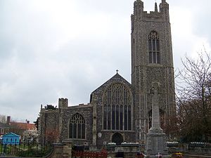
St Mary's Church, Bungay, from the westLocation from Suffolk
 St Mary's Church, Bungay
Coordinates: 52°27′20″N 1°26′16″E / 52.4556°N 1.4379°E OS grid reference TM 337 898 Location Bungay, Suffolk Country England Denomination Anglican Website Churches Conservation Trust Architecture Functional status Redundant Heritage designation Grade I Designated 9 May 1949 Architectural type Church Style Perpendicular Gothic Specifications Materials Flint and stone St Mary's Church, Bungay, is a redundant Anglican church in the town of Bungay, Suffolk, England. The church and the ruins of the adjacent priory have been designated by English Heritage as a Grade I listed building,[1] and are under the care of the Churches Conservation Trust.[2] The church stands in the centre of the town on St Mary's Street, the A144 road.[2][3]
Contents
History
St Mary's was built as the church to a Benedictine priory. This was established in the late 12th century, but the main part of the present church dates from the 14th–15th century. The Domesday Survey records a church dedicated to the Holy Cross in the town, and it is thought that St Mary's stands on the site of an earlier Saxon church. The priory was closed in 1536 as a result of the dissolution of the monasteries, St Mary's became a parish church, and a grammar school was established in one of the priory's chapels.[4] In 1577 the church was struck by lightning, and this event led to the Legend of the Black Dog (see below).[5][6]
The church was damaged in a great fire in the town in 1688. The roof of the south aisle and some of the fittings, including benches and possibly the pulpit, were burnt, but the roof of the nave was not damaged.[7] The south aisle was re-roofed in 1699, and the church re-opened in 1701.[1] In 1879 the tower was repaired, and the rest of the church was restored, at a cost of £3,000 (£230,000 as of 2011).[8][9] During the 20th century the size of the congregation declined and the church was declared redundant.[4] Its benefice has been united with that of Holy Trinity Church.[10] A society, The Friends of St Mary's, cleans the church and organises concerts and other events in the church.[4]
Architecture
Exterior
The church is constructed in flint and stone in Perpendicular style. Its plan consists of a nave with a clerestory, north and south aisles, and a tower.[9] The tower stands at the west end of the south aisle,[7] and it is surmounted by four tall crocketted pinnacles. There is no chancel.[9] The tower is 110 feet (33.5 m) high.[2] There are ruined remains of the priory in the churchyard to the east of the church.[2]
Interior
The arcades are supported on five columns consisting of clustered shafts.[7] The west window is particularly large, and has complicated tracery in its upper part. The bosses in the roof are carved with a variety of objects, including angels, a lion, two-headed eagles, and a bat. Near the entrance to the church is a dole cupboard, carved with a rat. Bread was placed in the dole cupboard to be given to the poor. Part of the church has been converted into a War Memorial Chapel. This contains a 17th-century Flemish panel depicting the Resurrection that was given to the church by the author H. Rider Haggard.[2] The two-manual organ was made by E. W. Norman, and was moved to the church from Rose Hall, Bungay. It was rebuilt in 1961 by Walker.[11] The ring consists of eight bells, all cast in 1820 by Thomas Mears II of the Whitechapel Bell Foundry.[12]
Legend of the Black Dog
The church was struck by lightning on Sunday, 4 August 1577. During the thunderstorm an apparition appeared, consisting of a black Hell Hound which dashed around the church, attacking members of the congregation. It then suddenly disappeared and re-appeared in Blythburgh church 12 miles (19 km) away, injuring members of the congregation there. The dog has been associated with Black Shuck, a dog haunting the coasts of Norfolk, Essex and Suffolk. An image of the Black Dog has been incorporated in the coat of arms of Bungay, and has been used in the titles of various enterprises associated with Bungay.[6]
See also
- List of churches preserved by the Churches Conservation Trust in the East of England
References
- ^ a b "Church of St Mary (including ruins of Benedictine convent), Bungay", The National Heritage List for England (English Heritage), 2011, http://list.english-heritage.org.uk/resultsingle.aspx?uid=1216850, retrieved 12 May 2011
- ^ a b c d e St Mary's Church, Bungay, Suffolk, Churches Conservation Trust, http://www.visitchurches.org.uk/Ourchurches/Completelistofchurches/St-Marys-Church-Bungay-Suffolk/, retrieved 25 March 2011
- ^ Bungay, Streetmap, http://streetmap.co.uk/grid/633552_289783_120, retrieved 7 March 2011
- ^ a b c Churches in Bungay: St Mary's Church, Sanderling Internet, http://www.bungay-suffolk.co.uk/community/worship.asp, retrieved 7 March 2011
- ^ "Bungay: History of Bungay", EDP24 (Archant Regional), 13 April 2010, http://www.edp24.co.uk/norfolk-life/village-guide/bungay_1_213335, retrieved 7 March 2011
- ^ a b History of the Black Dog of Bungay, Sanderling Internet, http://www.bungay-suffolk.co.uk/bungay/black-dog-legend.asp, retrieved 7 March 2011
- ^ a b c Suckling, Alfred (1846), The History and Antiquities of the County of Suffolk (University of London & History of Parliament Trust) 1
- ^ UK CPI inflation numbers based on data available from Lawrence H. Officer (2010) "What Were the UK Earnings and Prices Then?" MeasuringWorth.
- ^ a b c "Suffolk — Bungay", Kelly's Directory for Cambridgeshire, Norfolk & Suffolk, 1883, Kelly's Directory, pp. 824–828, http://apling.freeservers.com/Villages/Bungay.htm, retrieved 7 March 2011
- ^ Bungay, Holy Trinity with St Mary, Bungay, Church of England, http://www.achurchnearyou.com/bungay-holy-trinity-st-mary/, retrieved 7 March 2011
- ^ Suffolk, Bungay, St. Mary, St. Mary's Street (N00899), British Institute of Organ Studies, http://www.npor.org.uk/cgi-bin/Rsearch.cgi?Fn=Rsearch&rec_index=N00899, retrieved 7 March 2011
- ^ Bungay, S Mary, Dove's Guide for Church Bell Ringers, http://dove.cccbr.org.uk/detail.php?searchString=bungay&Submit=+Go+&DoveID=BUNGAY, retrieved 7 March 2011
External links
Categories:- Grade I listed buildings in Suffolk
- Grade I listed churches
- Church of England churches in Suffolk
- English Gothic architecture
- Churches preserved by the Churches Conservation Trust


Wikimedia Foundation. 2010.