- St Andrew's Church, Cranford
-
St Andrew's Church, Cranford 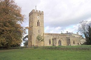
St Andrew's Church, Cranford, from the southwestLocation in Northamptonshire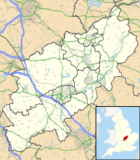
 St Andrew's Church, Cranford
Coordinates: 52°23′09″N 0°38′38″W / 52.3857°N 0.6440°W OS grid reference SP 923 772 Location Cranford St Andrew, Northamptonshire Country England Denomination Anglican Website Churches Conservation Trust History Dedication Saint Andrew Architecture Functional status Redundant Heritage designation Grade II* Designated 25 February 1957 Architectural type Church Style Norman, Gothic, Gothic Revival Groundbreaking 12th century Completed 1847 Specifications Materials Limestone with ironstone dressings, lead roofs St Andrew's Church, Cranford, is a redundant Anglican church in Cranford St Andrew, Northamptonshire, England. It has been designated by English Heritage as a Grade II* listed building,[1] and is under the care of the Churches Conservation Trust.[2] The church stands in the park of Cranford Hall, to the southwest of the house.[3]
Contents
History
St Andrew's dates from the later part of the 12th century, the nave arcade surviving from that time. The tower was added during the following century, at which time the church was largely rebuilt, and a north chapel was added. Further building took place in the 14th century when the clerestory and porch were added, and new windows were inserted. The south chapel was added in the following century. In 1674 the south chapel was refaced with ashlar.[3] In 1847 a north transept was added to form a family pew for the Robinsons of Cranford Hall.[4] The church was vested in the Churches Conservation Trust on 1 December 1996.[5]
Architecture
Exterior
The church is constructed in limestone rubble, part of which is rendered, and some of the dressings are in ironstone.[1] The roofs are covered in lead.[3] Its plan consists of a nave with a clerestory, a north aisle, a south porch and a north transept, a chancel with north and south chapels, and a west tower. The tower is in two stages with a tall lower stage and supported by buttresses. In the lower stage is a steeply pointed west doorway, with a lancet window above it, and small stair lights to its left. On the south side is another lancet window. In the upper stage on each side are two-light bell openings with Decorated tracery and quatrefoil heads, over which are three plain corbels, and a lancet window. On the south side the central corbel is replaced by a clock face. On the summit of the tower is a castellated parapet.[1]
There are also castellated parapets on the chancel and the porch, and plain parapets on the nave and chapels. In the south wall of the nave are a two-light square-headed Perpendicular window to the left of the porch, and a three-light window under a pointed arch on the right. In the wall of the south chapel is a doorway with an ogee head, over which is a stone dated 1674, and a two-light window. At the east end of the south chapel is a two-light window, the east window of the chancel contains a three-light Perpendicular window, and in the east wall of the north chapel is another three-light Perpendicular window. On the north side of the north chapel is a three-light window. The 19th-century north transept is in Perpendicular style. In the north aisle is a three-light window, and a two-light square-headed Perpendicular window.[1]
Interior
The arcade between the nave and the north aisle is Norman in style and consists of three bays. The arches are round-headed and are carried on cylindrical piers with plain capitals.[4] In the north chapel is a medieval piscina. The east window contains fragments of medieval and 17th-century glass. The pulpit dates from the 19th century and contains re-set 16th-century Flemish panels depicting biblical scenes. The font is octagonal and plain. In the church are memorials to members of the Fossebrok (or Fosbroke) and Robinson families.[1] The two-manual organ was built in 1883 by Trustam & Co of Bedford.[6] The ring consists of four bells. Two of these were cast in 1624 by William Haulsey, the third was cast in 1683 by Tobias III Norris, and the fourth dates from 1718 and was cast by Thomas I Eayre.[7] In the 1930s, when the church was still in use, its plate was described as including a cup from about 1570, a paten of 1813, and flagon of 1835.[3]
See also
- List of churches preserved by the Churches Conservation Trust in the English Midlands
References
- ^ a b c d e "Church of St Andrew, Cranford", The National Heritage List for England (English Heritage), 2011, http://list.english-heritage.org.uk/resultsingle.aspx?uid=1052098, retrieved 13 May 2011
- ^ St Andrew's Church, Cranford, Northamptonshire, Churches Conservation Trust, http://www.visitchurches.org.uk/Ourchurches/Completelistofchurches/St-Andrews-Church-Cranford-Northamptonshire/, retrieved 29 March 2011
- ^ a b c d Page, W.H., ed. (1930), "Parishes: Cranford St. Andrew", A History of the County of Northampton, Victoria County History (University of London & History of Parliament Trust) 3: pp. 186–189, http://www.british-history.ac.uk/report.aspx?compid=66285#s3, retrieved 22 October 2010
- ^ a b Baxter, Ron (2008), St Andrew, Cranford, Northamptonshire, Corpus of Romanesque Sculpture in Britain and Ireland, http://www.crsbi.ac.uk/search/county/site/ed-nh-crasa.html, retrieved 22 October 2010
- ^ (PDF) Diocese of Peterborough: All Schemes, Church Commissioners/Statistics, Church of England, 2011, p. 1, http://www.churchofengland.org/media/810809/peterborough%20-%20all%20schemes.pdf, retrieved 11 April 2011
- ^ Northamptonshire, Cranford St. Andrew, St. Andrew (D02144), British Institute of Organ Studies, http://www.npor.org.uk/cgi-bin/Rsearch.cgi?Fn=Rsearch&rec_index=D02144, retrieved 22 October 2010
- ^ Cranford St Andrew: St Andrew, Dove's Guide for Church Bell Ringers, http://dove.cccbr.org.uk/detail.php?searchString=cranford&Submit=+Go+&DoveID=CRANFORDSA, retrieved 22 October 2010
Categories:- Grade II* listed buildings in Northamptonshire
- Grade II* listed churches
- Church of England churches in Northamptonshire
- Norman architecture
- 12th-century architecture
- English Gothic architecture
- 13th-century architecture
- 14th-century architecture
- Gothic Revival architecture in England
- Religious buildings completed in 1847
- Churches preserved by the Churches Conservation Trust


Wikimedia Foundation. 2010.