- St Andrew's Church, Covehithe
-
St Andrew's Church, Covehithe 
St Andrew's Church, CovehitheLocation in Suffolk Coordinates: 52°22′36″N 1°42′20″E / 52.3768°N 1.7055°E OS grid reference TM 523 818 Location Covehithe, Suffolk Country England Denomination Anglican Website Churches Conservation Trust St Andrew, Covehithe History Dedication Saint Andrew Architecture Heritage designation Grade I Designated 27 November 1954 Architectural type Church Style Gothic Administration Parish Covehithe with Benacre Deanery Halesworth Archdeaconry Suffolk Diocese St Edmundsbury and Ipswich Province Canterbury Clergy Vicar(s) Revd Leonard John Payne St Andrew's Church, Covehithe, is a partly redundant Anglican church in the hamlet of Covehithe in the English county of Suffolk. It has been designated by English Heritage as a Grade I listed building.[1] Part of the church is in ruins and this is under the care of the Churches Conservation Trust.[2] The church stands on a lane leading directly towards the sea, in an area of coast which has suffered significant ongoing erosion.[2][3] The parish of Covehithe has been combined with neighbouring Benacre.[4]
Contents
History
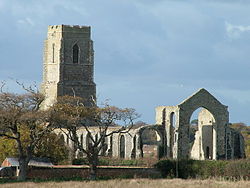
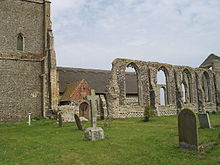
The oldest fabric in the original large medieval church dates from the 14th century, although most of it is from the 15th century. During the Civil War much of the stained glass was destroyed by the local iconoclast William Dowsing.[5] By the later part of that century the large church was too expensive for the parishioners to maintain, and they were given permission in 1672 to remove the roof and to build a much smaller church within it.[5][6] This small church is still in use, while the tower and the ruins of the old church are maintained by the Churches Conservation Trust.[2]
Architecture
Medieval church
This is constructed in random flint rubble with stone dressings. Its plan consists of a nave, a chancel, north and south seven-bay aisles, a north sacristy, and a west tower. The tower is still intact and is in three principal stages, with buttresses and a battlemented parapet. On the south side of the middle stage is an ogee-headed opening. There are bell openings on each side of the top stage, but their tracery is missing. The wall of the south aisle is more complete than the north wall, and contains six intact window openings. The chancel projects one bay beyond the aisles, and contains tall window openings in its north and south wall, and a large east window opening. The buttresses at the east end are decorated with chequered flushwork, and contain canopied niches for statues. Some of the carved corbels for the chancel roof are still present.[1]
Newer small church
The west end of the 17th-century church is built against the tower.[5] Its fabric includes much material re-used from the older church, and some brick. Its roof is thatched. The windows have two lights separated by wooden mullions, and contain diamond-leaded windows. Both the north and the south doorways have been re-used. The east window dates from the 19th century. Inside the church is a 15th-century carved octagonal font. At the west end are 15th-century pews with poppyhead carving. The wooden pulpit contains some 17th-century carving. Under the tower arch are the royal arms of George III.[1]
See also
- List of churches preserved by the Churches Conservation Trust in the East of England
References
- ^ a b c "Church of St Andrew, Covehithe", The National Heritage List for England (English Heritage), 2011, http://list.english-heritage.org.uk/resultsingle.aspx?uid=1032168, retrieved 13 May 2011
- ^ a b c St Andrew's Church, Covehithe, Suffolk, Churches Conservation Trust, http://www.visitchurches.org.uk/Ourchurches/Completelistofchurches/St-Andrews-Church-Covehithe-Suffolk/, retrieved 25 March 2011
- ^ Covehithe, Streetmap, http://streetmap.co.uk/grid/652174_281923_120, retrieved 19 February 2011
- ^ Covehithe with Benacre, St Andrew, Covehithe with Benacre, Church of England, http://www.achurchnearyou.com/covehithe-st-andrew/, retrieved 10 May 2011
- ^ a b c St Andrew, Covehithe, Suffolk Churches, http://www.suffolkchurches.co.uk/covehithe.htm, retrieved 19 February 2011
- ^ Covehithe, St Andrew's Church, Britain Express, http://www.britainexpress.com/attractions.htm?attraction=4123, retrieved 19 February 2011
Categories:- Grade I listed buildings in Suffolk
- Grade I listed churches
- Church of England churches in Suffolk
- English Gothic architecture
- Churches preserved by the Churches Conservation Trust
- Church ruins
Wikimedia Foundation. 2010.


