- Madison Group
-
Madison Limestone
Stratigraphic range: Mississippian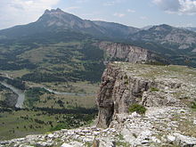
Thrusted segment of the Madison Limestone, Sun River canyon, MontanaType Geological formation Underlies Big Snowy Group Overlies Bakken Formation (Three Forks Group) Thickness up to 2,100 feet (640 m)[1] Lithology Primary Limestone Other Shale Location Named for Madison Range Named by A.C. Peale, 1893[2] Region South Dakota, Montana, Idaho, Colorado, Arizona, Alberta, Saskatchewan, Manitoba Country  United States,
  Canada
The Madison Limestone is a thick sequence of mostly carbonate rocks of Mississippian age in the Rocky Mountain and Great Plains areas of western United States. The rocks serve as an important aquifer as well as an oil reservoir in places. The Madison and its equivalent strata extend from the Black Hills of western South Dakota to western Montana and eastern Idaho, and from the Canadian border to western Colorado and the Grand Canyon of Arizona.
Contents
Age and nomenclature
The Madison is formally known as the Madison Group. In Montana, where its thickness reaches 1,700 feet (520 m), the group is subdivided into the Mission Canyon Formation and Lodgepole Formation. Equivalents of the Madison are named the Pahasapa Limestone in the Black Hills, Leadville Limestone (Colorado), Guernsey Limestone (Wyoming), and Redwall Limestone in the Grand Canyon. The upper part of the Madison Group, the Charles Formation in the subsurface of North Dakota and northern Montana, is not strictly an equivalent of the Madison Limestone as usually defined.[3]
Most of the Madison Limestones were deposited during Early to Middle Mississippian time (Tournaisian to Visean stages), about 359 to 326 million years ago. Older North American usage lists the Madison as being laid down during the Kinderhookian, Osagian, and Meramecian stages.
Neither a type locality nor derivation of the name was designated when the term "Madison Limestone" was first used by Peale (1893),[4] but since the original work focused on the area of Three Forks, Montana, it is likely that the name relates to outcrops along the Madison River, Montana. A reference section has been designated on the north side of Gibson Reservoir in SE/4 sec. 36, T. 22 N., R. 10 W., Patricks Basin quad, Teton Co., Montana.[5]
Lithology
Limestones and dolomites dominate the Madison. Because the rock is highly soluble, it often develops caves and karst topography. Lewis and Clark Caverns, Montana, is an example of a cave developed in the Madison. The rocks were deposited in a generally shallow marine setting, indicated by the richly fossiliferous rocks of the Madison. In the Williston Basin, water was shallow enough for oolite shoals to develop; they later became reservoirs for oil.[6] The gray cliffs along the Missouri River in the Gates of the Mountains, Montana are formed by Madison Limestone.[7]
Subdivisions
- Montana-Wyoming-Manitoba
The following formations are recognized in Montana, Wyoming and Manitoba, from top to base:
Sub-unit Age Lithology Max.
ThicknessReference Charles Formation Mississippian dolomitic limestone 244 m (800 ft) [8] Mission Canyon Formation Osagian white bioclastic limestone, oolitic calcarenite, occasionally dolomitized; anhydrite in the Williston Basin 183 m (600 ft) [9] Lodgepole Formation Kinderhookian lime mudstones, shale, chert, contains bitumen 245 m (800 ft) [10] - Saskatchewan
The following subdivisions (of formation rank) are recognized in Saskatchewan, from top to base:
Sub-unit Age Lithology Max.
ThicknessReference Poplar Beds Meramecian limestone, argillaceous dolomite, evaporite 152 m (500 ft) [11] Ratcliffe Beds Osagian dense dolomites, mudstone with three anhydrite beds 80 m (260 ft) [12] Midale Beds Osagian oolitic to pisolitic and skeletal grainstone to packstone with vuggy porosity, dolomite, porous wackestone 45 m (150 ft) [13] Foirbisher Evaporite Osagian supratidal anhydrite 9 m (30 ft) [13] Kisbey Sandstone Osagian porous silty dolomite and calcareous sandstone 10 m (30 ft) [14] Alida Beds Osagian oolitic to pisolitic grainstone and packstone, silty and dolomitic limestone, crinoidal limestones 63 m (210 ft) [15] Tilston Beds Kinderhookian oolitic, pisolitic and crinoidal grainstone and packstone; cherty or dolomitic crystalline limestone, silty limestone, anhydrite 80 m (260 ft) [16] Souris Valley Beds Kinderhookian argillaceous limestone, calcareous shale, chert 176 m (580 ft) [17] See also
References
- ^ Lexicon of Canadian Geological Units. "Madison Group". http://cgkn1.cgkn.net/weblex/weblex_litho_detail_e.pl?00053:008973. Retrieved 2009-03-26.
- ^ Peale, A.C., 1893. The Paleozoic section in the vicinity of Three Forks, Montana. United States Geological Survey, Bull. 110, p.9-56.
- ^ Mississippian System, by Lawrence C. Craig, in Geologic Atlas of the Rocky Mountain Region, Rocky Mountain Association of Geologists, Denver, CO, 1972: p. 100-110
- ^ Peale, A.C., 1893, The Paleozoic section in the vicinity of Three Forks, Montana, with petrographic notes by G.P. Merrill: U.S. Geological Survey Bulletin, 110, 56 p.
- ^ Mudge, M.R., Sando, W.J. and Dutro, J.T., Jr., 1962, Mississippian rocks of the Sun River Canyon area, Sawtooth Range, Montana: American Association of Petroleum Geologists Bulletin, v. 46, no. 11, p. 2003-2018
- ^ Mississippian Madison group stratigraphy and sedimentation in Wyoming and southern Montana, by John Michael Andrichuk, AAPG Bulletin; November 1955; v. 39; no. 11; p. 2170-2210
- ^ River Log and Road Log: Thrust Faulting near Gates of the Mountains, Lombard, Lewis & Clark Canyon, Montana Geological Society 1994 Guidebook, James L. Cannon, Gary G. Thompson, and John R. Warne, editors
- ^ Lexicon of Canadian Geologic Units. "Charles Formation". http://cgkn1.cgkn.net/weblex/weblex_litho_detail_e.pl?00053:002766. Retrieved 2010-01-07.
- ^ Lexicon of Canadian Geologic Units. "Mission Canyon Formation". http://cgkn1.cgkn.net/weblex/weblex_litho_detail_e.pl?00053:009922. Retrieved 2010-01-07.
- ^ Lexicon of Canadian Geologic Units. "Lodgepole Formation". http://cgkn1.cgkn.net/weblex/weblex_litho_detail_e.pl?00053:008638. Retrieved 2010-01-07.
- ^ Lexicon of Canadian Geologic Units. "Poplar Beds". http://cgkn1.cgkn.net/weblex/weblex_litho_detail_e.pl?00053:012052. Retrieved 2010-01-07.
- ^ Lexicon of Canadian Geologic Units. "Ratcliffe Beds". http://cgkn1.cgkn.net/weblex/weblex_litho_detail_e.pl?00053:012509. Retrieved 2010-01-07.
- ^ a b Lexicon of Canadian Geologic Units. "Midale Beds". http://cgkn1.cgkn.net/weblex/weblex_litho_detail_e.pl?00053:009713. Retrieved 2010-01-07.
- ^ Lexicon of Canadian Geologic Units. "Kisbey Sandstone". http://cgkn1.cgkn.net/weblex/weblex_litho_detail_e.pl?00053:007682. Retrieved 2010-01-07.
- ^ Lexicon of Canadian Geologic Units. "Alida Beds". http://cgkn1.cgkn.net/weblex/weblex_litho_detail_e.pl?00053:000230. Retrieved 2010-01-07.
- ^ Lexicon of Canadian Geologic Units. "Tilston Beds". http://cgkn1.cgkn.net/weblex/weblex_litho_detail_e.pl?00053:015229. Retrieved 2010-01-07.
- ^ Lexicon of Canadian Geologic Units. "Souris Valley Beds". http://cgkn1.cgkn.net/weblex/weblex_litho_detail_e.pl?00053:014089. Retrieved 2010-01-07.
Western Canadian Sedimentary Basin Hydrocarbon history Depositional Regions Southern Alberta · Central Alberta · Northwestern Alberta Plains · South-central Canadian Rockies foothills · North-east Plains · North-central foothills · Liard River · Fort Nelson · Northern Rocky Mountains · Fort St. John · Saskatchewan · Western ManitobaSaskatchewan Cypress Hills FM · Ravenscrag FM · Frenchman FM · Whitemud FM · Eastend FM · Bearpaw FM · Judith River GRP · Belly River FM · Oldman FM · Foremost FM · Lea Park FM · Pakowki FM · Milk River FM · Colorado GRP · Viking FM · Mannville GRP (Pense FM · Cantuar FM · Success FM) · Vanguard FM · Ellis GRP (Swift FM · Rierdon FM · Sawtooth FM) · Shaunavon FM · Piper FM · Gravelbourg FM · Gypsum Springs FM · Watrous FM · Big Snowy GRP · Madison GRP (Charles FM (Poplar · Ratcliffe · Midale) · Mission Canyon FM (Kisbey SS · Alida · Tilston) · Lodgepole FM - Souris Valley) · Three Forks GRP (Bakken FM · Big Valley FM · Torquay FM) · Saskatchewan GRP (Birdbear FM · Duperow FM) · Manitoba GRP (Souris River FM) · Elk Point GRP (Davson Bay FM · Prairie FM · Winnipegosis FM · Ashern FM) · Interlake FM · Stonewall FM · Stony Mountain FM · Herald FM · Yeoman FM · Winnipeg FM · Deadwood FM · Canadian ShieldCategories:- Geologic formations of the United States
- Geologic formations of Canada
- Geology of Montana
- Geology of North Dakota
- Stratigraphy of Saskatchewan

Wikimedia Foundation. 2010.