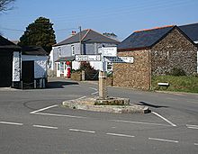
- Pensilva
-
Coordinates: 50°30′12″N 4°24′38″W / 50.50328°N 4.41045°W
Pensilva is a village in east Cornwall, United Kingdom. It is situated at OS grid ref SX291697 approximately four miles (6km) northeast of Liskeard[1]. Nearby settlements include Charaton Cross and Middlehill.
The original small settlement grew rapidly during the nineteenth century in response to industrial activity on the moorland north and west of the village.[2]
References
- ^ Ordnance Survey: Landranger map sheet 201 Plymouth & Launceston ISBN 9780319231463
- ^ http://www.historic-cornwall.org.uk/cisi/pensilva/pensilva.htm Historic Cornwall website. Retrieved April 2010
Geography of Cornwall Unitary authorities Major settlements Bodmin • Bude • Callington • Camborne • Camelford • Falmouth • Fowey • Hayle • Helston • Launceston • Liskeard • Looe • Lostwithiel • Marazion • Newlyn • Newquay • Padstow • Par • Penryn • Penzance • Porthleven • Redruth • Saltash • St Austell • St Blazey • St Columb Major • St Ives • St Just-in-Penwith • St Mawes • Stratton • Torpoint • Truro • Wadebridge
See also: Civil parishes in CornwallRivers Topics History • Status debate • Flag • Culture • Places • People • The Duchy • Diocese • Politics • Hundreds/shires • Places of interest • full list...Categories:- Cornwall geography stubs
- Villages in Cornwall
Wikimedia Foundation. 2010.

