- Maradi Region
-
Maradi — Region — Location within Niger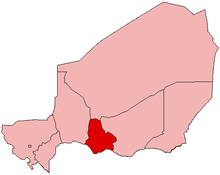
Coordinates: 13°30′N 7°6′E / 13.5°N 7.1°ECoordinates: 13°30′N 7°6′E / 13.5°N 7.1°E Country  Niger
NigerCapital Maradi Area – Total 35,100 km2 (13,552.2 sq mi) Population (2001 census) – Total 2,235,748 – Density 63.7/km2 (165/sq mi) Time zone West Africa Time (UTC+1) The Region of Maradi is one of eight Regions of Niger. It is located in south-center Niger, east of the Region of Tahoua, west of Zinder, and north of Nigeria's city of Kano. The administrative center is at Maradi. The population of the Region is majority Hausa.
Contents
Geography
Most of the 35,100 km²[1] of land is classified as "Sahel," though the northern parts head toward desert, and the very southern edges along the border with Nigeria get almost 600 mm a year in average rainfall, with some areas receiving as much as 650-700 mm in better years.[1]
Economy
The Maradi (Niger)-Nigeria border dips south below the Region's capital, forming an area sometimes called the "breadbasket" of Niger. While Tobacco, mangoes, wheat, soy beans and even cotton are cultivated in some areas, most crops are groundnuts grown as a commercial crop, and the national subsistence of millet, sorghum and cow peas.
Population
Culturally, the Maradi Region forms the west central section of Nigerien Hausaland, which extends along the Nigeria border (and south) west to Dogondoutchi and east to just beyond Zinder. As well, minority populations of Fula people (including but not limited to the Wodaabe who predominate to the north and east of the region), Bozo people, ans well as Tuareg and dependent groups, especially in the north of the region and in spots along trade routes. It is the most densely populated region of Niger.[1]
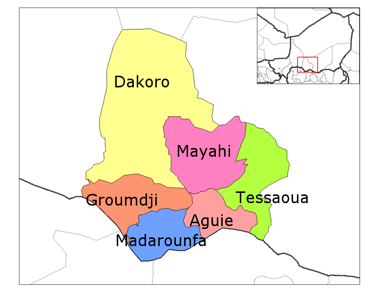
 Departments of Maradi
Divisions and borders
Maradi is divided into 6 Departments:
- Aguie Department
- Dakoro Department
- Groumdji Department
- Madarounfa Department
- Mayahi Department
- Tessaoua Department
Maradi has the following foreign borders:
- Katsina State, Nigeria - south
- Zamfara State, Nigeria - southwest
- Sokoto State, Nigeria - far southwest
Domestically, it borders the following Regions:
- Tahoua Region - west
- Agadez Region - north
- Zinder Region - east
See also
References
- ^ a b c Samuel Decalo. Historical Dictionary of Niger (3rd ed.). Scarecrow Press, Boston & Folkestone, (1997) ISBN 0810831368 pp.209-210
External links
Agadez Region Diffa Region Dosso Region Maradi Region Aguie Department • Dakoro Department • Guidan Roumdji Department • Madarounfa Department • Mayahi Department • Tessaoua DepartmentTahoua Region Tillabéri Region Zinder Region Categories:- Niger geography stubs
- Maradi Region
- Regions of Niger

Wikimedia Foundation. 2010.