- Zinder
-
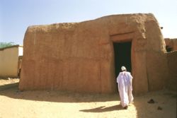
Zinder An ancient mudbrick home in the Birini old town. Coordinates: 13°48′19″N 8°59′18″E / 13.80528°N 8.98833°ECoordinates: 13°48′19″N 8°59′18″E / 13.80528°N 8.98833°E Country Niger Zinder Region Matameye Department capital of Sultanate of Damagaram 1736 Elevation 479 m (1,572 ft) Population (2001 census)[1] – Total 170,574 Zinder (which is locally called Damagaram) is the second largest city in Niger, with a population of 170,574 (2001 census)[1] by 2005 was estimated to be over 200,000. It is situated 861 km (535 mi) east of the capital Niamey and 240 km (150 mi) north of the Nigerian city of Kano.
Contents
History
Zinder rose from a small Hausa village to an important center of the Trans-Saharan trade with the founding of the Sultanate of Damagaram in 1736 by Kanouri aristocrats. The large fortress of the southeast central city (Birini) was built shortly thereafter, and became a major hub for trade south through Kano and east to Bornu. The Tuareg encampments and trade houses of the Hausa town (Zengou) expanded with this trade. The French conquered the city in 1899, and placed the capital of the new Niger Military Territory there in 1911. In 1926, following fears of Hausa revolts and improving relations with the Djerma of the west, the capital was transferred back to the village of Niamey.
Zinder today
Today, Zinder comprises three main areas. Birni, the old town, is home to Zinder Great Mosque and the Zinder Sultan's Palace, as well as a museum. Zengou, the old Hausa settlement, is known for its vernacular architecture. Sabon Gari (the new town), between Birni and Zengou, is the commercial centre, known for its large market. The city now sprawls to the north and west, extending to the Karkada section, in the north. Other neighborhoods include Garin Mallam and Gawon Kollia.
The city has many distinctive granite rocks which can result in standing water during the rainy season, though the city has a long history of water shortages. Recently water was piped by a Chinese-owned company from the north to provide water to most of the city, however, this problem is likely to continue due to expected population growth.
Zinder Airport (code: ZND) is located a few miles to the southwest of the town.[2]
References
- Fallingrain.com: Directory of Cities and Towns in Departement de Zinder, Niger
- Columbia Encyclopedia:Zinder[dead link]
- ZINDER, Encyclopedia Britannica (1911)
- James Decalo. Historical Dictionary of Niger. Scarecrow Press/ Metuchen. NJ - London (1979) ISBN 0810812290
- Finn Fuglestad. A History of Niger: 1850-1960. Cambridge University Press (1983) ISBN 0521252687
- Jolijn Geels. Niger. Bradt UK/ Globe Pequot Press USA (2006) ISBN 9781841621524
External links
- Zinder travel guide from Wikitravel
- Franco-Nigerien Cultural Centre Zinder (Centre culturel franco-nigérien de Zinder) CCFN-Z. Les Centres Culturels franco-nigériens. Ambassade de France à Niamey.
- Friends of Niger: Photos from December 2000 taken in old quarter and the sultan's palace in Zinder.
- Photo 1
- Photo 2
Categories:- Zinder
- Zinder Region
- Populated places in Niger
- Niger geography stubs
Wikimedia Foundation. 2010.


