- Agadez Region
Demographic info|name=Agadez Region
capital=Agadez
population=321,639
census=2001
area=634,209
density=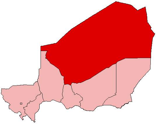
Agadez is an administrative Region in
Niger . Agadez covers 634,209 km². The capital of the department isAgadez .Description
The 667 799 km² of Agadez Region represents 52% of the total area of Niger, the largest of its 7 regions. Despite the size Agadez is sparesely populated, its 321 639 inhabitants are only 2,9% of the total population of Niger, with a population density of only 0.5 people per/km². The region includes the vast
Ténéré Saharan desert, dune seas like theErg of Bilma , and the mountains of theAïr . Much of its population comprises nomadic or semi-nomadic peoples: theTuareg ,Toubou , WadoobeFula . In the towns and oasies there are populations of settledKanuri (in the east),Hausa , andSonghay . Traversed for centuries by theTrans Saharan trade , its oasis towns of the Aïr and the eastern Kaouar Cliffs are known for theirgarden s,salt manufacture, and date cultivation. In the late 1990s, tourism became a large industry here, and the Uranium town ofArlit provides some 20% of the foreign exchange for the country.Tuareg insurgencies against the Niger government in the 1990s and mid 2000s and drought in the 1970s, 80s, and 2002 have led to humanitarian crises and damaged the region's economy.ubdivisions
Agadez is divided into 3 Departments and one Commune.
Borders
Agadez has the following foreign borders, including Niger's only borders on
Libya andAlgeria :
*Kidal Region, Mali - west
*Tamanghasset Wilayah, Algeria - northwest
*Ghat Sha'biyah, Libya - north
*Murzuq Sha'biyah, Libya - northeast
*Bourkou-Ennedi-Tibesti Region, Chad - eastDomestically, it borders the following departments:
*Diffa Region - southeast
*Zinder Region - south, east of Maradi
*Maradi Region - south, west of Maradi
*Tahoua Region - southwestee also
*
Departments of Niger
*Regions of Niger
*Communes of Niger External links
*wikitravel|Agadez|Agadez
Wikimedia Foundation. 2010.