Milk River Ridge

Milk River Ridge

The Milk River Ridge is a high, flat ridge in southwestern Alberta, Canada. It is about 2,700 square kilometers (1,000 sq mi) in area. Its plateau is about 1,219 meters (4,023 feet) above sea level - which is about 274 meters (904 feet) higher than Lethbridge to its north. The Milk River flows through the plateau.

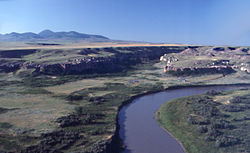
Milk River Ridge and River, Sweetgrass Hills in background

The ridge was formed thousands of years ago as the glaciers that once covered Canada retreated. The area was one of the few parts of Canada to not be over-run by the glaciers during the last Ice Age.

Because of its height, it can be especially windy on the plateau - especially when the Chinook blows in. Though rare, it is also not unheard of to have snow in the summer. Two summer snowfalls of note in recent years are August 21–23, 1992 (up to three feet), and July 15, 1999 (at least one foot).

The rolling grasslands provide habitat for mule deer, pronghorn antelope, white-tailed deer, yellow-bellied marmot and birds of prey such as ferruginous hawk, golden eagle and prairie falcon.

External links

Coordinates: 49°15′N 112°30′W / 49.25°N 112.5°W / 49.25; -112.5


Wikimedia Foundation. 2010.

Игры ⚽ Поможем сделать НИР

Look at other dictionaries:

  • Milk River Ridge Reservoir — For other uses, see Milk River. Milk River Ridge Reservoir Location Warner County No. 5, Alberta Coordinates …   Wikipedia

  • Milk River — The Milk River may refer to: Rivers Canada and the United States The Milk River (British Columbia), a tributary of the upper Fraser River in Canada The Milk River (Michigan), United States The Milk River (Montana Alberta), a tributary of the… …   Wikipedia

  • Milk River (Alberta–Montana) — Coordinates: 48°03′26″N 106°19′07″W / 48.05722°N 106.31861°W / 48.05722; 106.31861 …   Wikipedia

  • Doig River — Origin Halverson Ridge, Clear Hills County, Alberta 57°00′00″N 119°29′53″W /  …   Wikipedia

  • Milk shark — Conservation status …   Wikipedia

  • Notikewin River — Origin Clear Hills 56°39′57″N 119°26′23″W /  …   Wikipedia

  • North Saskatchewan River — Coordinates: 53°14′07″N 105°04′58″W / 53.23528°N 105.08278°W / 53.23528; 105.08278 …   Wikipedia

  • Oldman River — See also: Old Man River (disambiguation) Oldman River Oldman River seen from Veteran Memorial Highway Origin Canadian Rockies …   Wikipedia

  • Clearwater River (Saskatchewan) — For other rivers called Clearwater, see Clearwater River (disambiguation). Clearwater Valley south of Fort McMurray Clearwater River is the name of a river in the Canadian provinces of Saskatchewan and Alberta …   Wikipedia

  • Clearwater River (Alberta) — For other rivers called Clearwater, see Clearwater River (disambiguation). The Clearwater River of southern Alberta, Canada. Clearwater is a river of southern Alberta, Canada. Situated entirely in the Canadian Rockies and the Rocky Mountain… …   Wikipedia

Share the article and excerpts

Direct link
Do a right-click on the link above
and select “Copy Link”