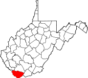
- Maybeury, West Virginia
-
Maybeury — Census-designated place — Location of Maybeury in West Virginia Coordinates: 37°22′15″N 81°21′59″W / 37.37083°N 81.36639°WCoordinates: 37°22′15″N 81°21′59″W / 37.37083°N 81.36639°W Country United States State West Virginia County McDowell Area[1] - Total 1.668 sq mi (4.3 km2) - Land 1.667 sq mi (4.3 km2) - Water 0.001 sq mi (0 km2) Elevation[2] 2,073 ft (632 m) Population (2010)[3] - Total 234 - Density 140.3/sq mi (54.2/km2) Time zone Eastern (EST) (UTC-5) - Summer (DST) EDT (UTC-4) ZIP code 24861[4] Area code(s) 304 FIPS code GNIS feature ID 1555071[2] Maybeury is an unincorporated census-designated place in McDowell County, West Virginia, United States, located on US Route 52 between Northfork and Bramwell. As of the 2010 census, its population was 234.[3]
In 1890, it was the largest town in McDowell County with a population of 875. This was due to the coal mining start-ups in the town. Maybeury was the 5th largest town/city south of the State Capital, Charleston, and listed as the 31st largest town/city in the entire state.[5]
John F. Kennedy stopped in Maybeury at the Esso station during his presidential primary campaign in 1960. During a speech in Canton, Ohio on September 27, 1960, he stated "McDowell County mines more coal than it ever has in its history, probably more coal than any county in the United States and yet there are more people getting surplus food packages in McDowell County than any county in the United States. The reason is that machines are doing the jobs of men, and we have not been able to find jobs for those men."[6]
The now demolished Pocahontas Fuel Company Store was listed on the National Register of Historic Places in 1992.[7]
References
- ^ "US Gazetteer files: 2010, 2000, and 1990". United States Census Bureau. 2011-02-12. http://www.census.gov/geo/www/gazetteer/gazette.html. Retrieved 2011-04-23.
- ^ a b U.S. Geological Survey Geographic Names Information System: Maybeury, West Virginia. Retrieved on 2008-08-19.
- ^ a b "American FactFinder". United States Census Bureau. http://factfinder2.census.gov. Retrieved 2011-05-14.
- ^ "Maybeury WV". ZIP Code Lookup. http://www.zipinfo.com/cgi-local/zipsrch.exe?cnty=cnty&ac=ac&zip=Maybeury+WV&Go=Go. Retrieved 2008-08-19.
- ^ "Some History of West Virginia" by Jeff Miller, Largest West Virginia cities, by past censuses - 1890 http://jeff560.tripod.com/census.html
- ^ "The American Presidency Project" http://www.presidency.ucsb.edu/ws/index.php?pid=74231
- ^ "National Register Information System". National Register of Historic Places. National Park Service. 2010-07-09. http://nrhp.focus.nps.gov/natreg/docs/All_Data.html.
Municipalities and communities of McDowell County, West Virginia Cities Towns CDPs Unincorporated
communitiesAlgoma | Antler | Apple Grove | Asco | Ashland | Atwell | Avondale | Beartown | Big Four | Bishop | Black Wolf | Bottom Creek | Canebrake | Capels | Caretta | Carlos | Carswell | Coalwood | Eckman | Elkhorn | English | Ennis | Erin | Faraday | Garland | Gilliam | Havaco | Hemphill | Hensley | Hull | Isaban‡ | Jacobs Fork | Jed | Jenkinjones | Johnnycake | Jolo | Krollitz | Kyle | Landgraff | Leckie | Lex | Lila | Litwar | Longpole | Maitland | McDowell | Mohawk | Mohegan | Monson | Newhall | Panther | Paynesville | Powhatan | Premier | Rift | Rockridge | Rolfe | Sandy Huff | Six | Skygusty | Squire | Superior | Switchback | Twin Branch | Union City | Upland | Vallscreek | Worth | Wyoming City | Yerba | Yukon
Footnotes ‡This populated place also has portions in an adjacent county or counties
Categories:- Populated places in McDowell County, West Virginia
- Census-designated places in West Virginia
Wikimedia Foundation. 2010.


