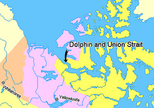
- Dolphin and Union Strait
-
Dolphin and Union Strait lies in both the Northwest Territories and Nunavut, Canada, between the mainland and Victoria Island. It links Amundsen Gulf, lying to the northwest, with Coronation Gulf, lying to the southeast. The southeastern end of the strait is marked by Austin Bay.
The Inuit who use this area have been variously known as the Copper Eskimos, the Copper Inuit or, the "People at the end of the world," because few other aboriginal groups had continuously used the area before. This is partly why the first explorers who ventured into this awe-inspiring, lethally-formidable landscape, were amazed by the "blond" Inuit they had encountered.
There are several islands within the strait, including the Liston and Sutton Islands, historically home to the Noahonirmiut band of Copper Inuit.[1]
The strait is about 161 km (100 mi) long and ranges from 32 to 64 km (20 to 40 mi) in width. When frozen, it is used by Barren-ground Caribou, labeled the "Dolphin and Union" herd, to reach Victoria Island] for the summer and to return to the mainland for the winter. Eider ducks are also found in the strait.
The caribou are known locally as Tuktu which is understood across the circumpolar world. Conversely, Eider ducks are called Kingalik which means simply, Big-Nose.
In recent decades, the local Inuvialuit have seen the reduction in average winter sea-ice thickness from roughly 6 to 7 ft (1.8 to 2.1 m) in the early 1960s to about 110 to 120 cm (43 to 47 in) even in the dead of winter today. There is also a preponderance of new species from flies to wasps, and new birds arriving that have never been seen before; grizzlies roam where they were once that most rare curiosity.
References
- ^ Stefansson, Vilhjalmur (1914). The Stefánsson-Anderson Arctic Expedition of the American Museum: Preliminary Ethnological Report. New York: The Trustees of the American Museum. p. 26. OCLC 13626409. http://books.google.com/books?id=-NhBAAAAIAAJ&pg=PA50&lpg=PA50&dq=%22Prince+Albert+Sound%22&source=web&ots=P6Beu2wRa-&sig=3aBgqcaIUflYJwZp4-8ySVYkKTY&hl=en&sa=X&oi=book_result&resnum=3&ct=result.
Coordinates: 69°7′59″N 116°0′0″W / 69.13306°N 116°W
Straits of Nunavut Kitikmeot Region Kivalliq Region Qikiqtaaluk Region Hydrography of the Northwest Territories Rivers Arctic Red · Back · Coppermine · Fond du Lac · Great Bear · Hay · Horn · Hornaday · Kagloryuak · Keele · Kotaneelee · Liard · Mackenzie · North Nahanni · Petitot · Redstone · Roscoe · Slave · South Nahanni · Trout · Yellowknife · more...Lakes Artillery · Aylmer · Blackwater · Boyd · Buffalo · Clinton-Colden · Colville · Faber · Firedrake · Great Bear · Great Slave · Hottah · Howard · Kakisa · Kasba · Keller · Lac Belot · Lac de Gras · Lac des bois (Northwest Territories) · Lac La Martre · Lynx · MacKay · Mosquito · Napaktulik · Nonacho · Point · Selwyn · Snowbird · Tahiryuak · Tathlina · Trout · Tulemalu · Wholdaia · more...Coastal features Amundsen Gulf · Beaufort Sea · Dolphin and Union Strait · Fitzwilliam Strait · Hazen Strait · Kellett Strait · Liddon Gulf · M'Clure Strait · Minto Inlet · Murray Inlet · Prince of Wales Strait · Richard Collinson Inlet · Prince Albert Sound · Wilkins StraitCategories:- Straits of the Northwest Territories
- Straits of Kitikmeot Region
- Victoria Island (Canada)
- Kitikmeot Region, Nunavut geography stubs
- Northwest Territories geography stubs
- Arctic stubs
Wikimedia Foundation. 2010.

