- Halamish
-
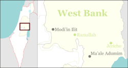
Halamish Founded November 1, 1977 Founded by Gush Emunim Council Mateh Binyamin Region West Bank Affiliation Amana Coordinates 32°0′29.07″N 35°7′37.98″E / 32.008075°N 35.1272167°ECoordinates: 32°0′29.07″N 35°7′37.98″E / 32.008075°N 35.1272167°E Population 1054 (2009) Website Neve Tzuf Halamish Halamish (Hebrew: חַלָּמִישׁ. lit. Flint), also known as Neveh Tzuf (Hebrew: נווה צוף, lit. Nectar Home), is a communal Israeli settlement in the West Bank, located in the southwestern Samarian hills to the north of Ramallah, 10.7 kilometers east of the Green line. The Orthodox Jewish community with a population of 1,054 (2009) was established in 1977. It falls under the jurisdiction of Mateh Binyamin Regional Council.[1]
The international community considers Israeli settlements in the West Bank illegal under international law, but the Israeli government disputes this.[2]
According to a Peace Now-report of 2006, 33 percent of the land Neveh Tzuf is built on, is privately owned, all or most of it by Palestinians.[3] According to Israeli law, settlements on privately owned Palestinian land are illegal.[4]
The settlement of Neveh Tzuf has several outposts,[5] and is home to the religious pre-army Mechina Elisha.[6]
Contents
History
On 16 October 1977, two groups of settlers, one religious, calling itself “Neveh Tzuf” and one secular, called “Neveh Tzelah” with a total of 40 families moved into the abandoned former British Tegart fort building near the Palestinian village Nabi Salih.[7] After months of harsh living conditions and after the murder of a Jew at the entrance to the settlement, only seven of the original settlers remained.[citation needed]
The original name of the settlement, Neveh Tzuf, was rejected by the government naming committee, arguing that it might be misleading since the biblical location, Eretz Tzuf, was elsewhere. The naming committee gave the new settlement the official name 'Halamish' instead, and since this was rejected by the settlers, both names are used for the settlement.[7]
Israeli-Palestinian conflict
Residents of the nearby Palestinian village Deir Nidham went to the Supreme Court of Israel and claimed ownership of the Havlata Hill, which is now in the centre of Halamish. Based on aerial photos from the turn of the 20th century, showing the disputed land to be barren, and Ottoman Empire land law specifying that land not worked for over ten years becomes state land, the land on that hill was declared state land and freed for settlement constructions. This court ruling became the precedent for future land ownership disputes.[8]
The residents of the nearby Palestinian village of Nabi Salih regularly protest the seizure of their land by the settlers of Halamish.[9]
See also
References
- ^ "Settlements List". www.peacenow.org.il. http://peacenow.org.il/eng/sites/default/files/settlements_database_1.xls. Retrieved 31 March 2011.
- ^ "The Geneva Convention". BBC News. 10 December 2009. http://news.bbc.co.uk/2/hi/middle_east/1682640.stm. Retrieved 27 November 2010.
- ^ In the data provided by the Civil Administration “there is no mention of whether the private land is owned by Palestinians or by Jews... Nevertheless, it is highly probable that most of the land that is marked here as private land (if not all of it) is privately-owned Palestinian land”.“Settlement are built on Private Palestinian Land”. Peace Now, March 14, 2007
- ^ “G U I L T Y! Construction of Settlements upon Private Land – Official Data”. Peace Now, 2006
- ^ "Settlement Outposts". Foundation for Middle East Peace. http://fmep.org/settlement_info/settlement-info-and-tables/stats-data/settlement-outposts/?searchterm=Halamish. Retrieved 31 March 2011.
- ^ "Mechinot". Jewish Agency. http://www.jafi.org/NR/exeres/5545EB1C-D2EA-4141-AC2E-E213521F1481. Retrieved 31 March 2011.
- ^ a b Hoberman, Haggai (2008) (in Hebrew). Keneged Kol HaSikuim [Against All Odds] (1st ed.). Sifriat Netzarim.
- ^ Hoberman, Haggai (2008) (in Hebrew). Keneged Kol HaSikuim [Against All Odds] (1st ed.). Sifriat Netzarim page = 169.
- ^ Gideon Levy (22 April 2010). "A spa for Samaria. The 'white intifada' is spreading. After Bil'in and Na'alin, the village of Nabi Saleh has joined the popular protest. Every Friday, villagers demonstrate against the expropriation of a spring.". Haaretz. http://www.haaretz.com/weekend/magazine/a-spa-for-samaria-1.284709. Retrieved 31 March 2011.
External links
- "Neve Tzuf". Jewish Agency. http://www.jewishagency.org/JewishAgency/English/Aliyah/Absorpton+Options/Municipal+and+Community+Absorption/Neve+Tzuf.htm?WBCMODE=presentationunpublished.
- "Neve Tzuf". Nefesh B'Nefesh, community guide. http://www.nbn.org.il/communities/template/community/33.
Communal
settlementsAlmon (Anatot) · Alon · Ateret · Beit Horon · Dolev · Eli · Geva Binyamin (Adam) · Giv'on HaHadasha · Halamish (Neveh Tzuf) · Hashmonaim · Kfar Adumim · Kfar HaOranim (Menora/Giv'at Ehud) · Kokhav HaShahar · Kokhav Ya'akov · Ma'ale Levona · Ma'ale Mikhmas · Mitzpe Yeriho · Na'ale · Nahliel · Neria (Talmon Bet) · Nili · Nofei Prat · Ofra · Psagot · Rimonim · Shilo · Shvut Rachel · TalmonIndustrial Zones Sha'ar Binyamin Industrial ZoneOutposts Ahia · Adei Ad · Amona, Mateh Binyamin* · Esh Kodesh · Giv'at Asaf · Giv'at Har'el · Harasha · Keeda* · Ma'ale Shlomo · Migron · Mitzpe Dani · Mitzpe Hagit · Mitzpe Kramim · Neveh Erez · Oz-Zion · Yishuv HaDa'at
(*Organised as a communal settlement)Categories:- Mateh Binyamin Regional Council
- Religious Israeli settlements
- Populated places established in 1977
Wikimedia Foundation. 2010.


