- Mevo Horon
-
Mevo Horon 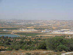
Founded 1970 Founded by Ezra members Council Mateh Binyamin Region Latrun Affiliation Agudat Israel Workers Coordinates 31°50′57.04″N 35°2′9.34″E / 31.8491778°N 35.0359278°ECoordinates: 31°50′57.04″N 35°2′9.34″E / 31.8491778°N 35.0359278°E 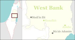
 Mevo Horon
Website mevo-horon.org.il Mevo Horon (Hebrew: מְבוֹא חוֹרוֹן, lit. Horon Gateway) is an Israeli settlement and religious moshav shitufi and Israeli settlement in the West Bank. Located near Latrun and Modi'in, it falls under the jurisdiction of Mateh Binyamin Regional Council. In 2007 it had a population of 1,200. The international community considers Israeli settlements in the West Bank illegal under international law, but the Israeli government disputes this.[1]
The village was established in 1970 by members of the Ezra youth movement, and was the first village in the Mateh Binyamin council area.
References
- ^ "The Geneva Convention". BBC News. 10 December 2009. http://news.bbc.co.uk/2/hi/middle_east/1682640.stm. Retrieved 27 November 2010.
External links
- Village website (Hebrew)
Matityahu · Mevo HoronCommunal
settlementsAlmon (Anatot) · Alon · Ateret · Beit Horon · Dolev · Eli · Geva Binyamin (Adam) · Giv'on HaHadasha · Halamish (Neveh Tzuf) · Hashmonaim · Kfar Adumim · Kfar HaOranim (Menora/Giv'at Ehud) · Kokhav HaShahar · Kokhav Ya'akov · Ma'ale Levona · Ma'ale Mikhmas · Mitzpe Yeriho · Na'ale · Nahliel · Neria (Talmon Bet) · Nili · Nofei Prat · Ofra · Psagot · Rimonim · Shilo · Shvut Rachel · TalmonIndustrial Zones Sha'ar Binyamin Industrial ZoneOutposts Ahia · Adei Ad · Amona, Mateh Binyamin* · Esh Kodesh · Giv'at Asaf · Giv'at Har'el · Harasha · Keeda* · Ma'ale Shlomo · Migron · Mitzpe Dani · Mitzpe Hagit · Mitzpe Kramim · Neveh Erez · Oz-Zion · Yishuv HaDa'at
(*Organised as a communal settlement)Categories:- Mateh Binyamin Regional Council
- Moshavim
- Religious Israeli settlements
- Populated places established in 1970


Wikimedia Foundation. 2010.