- Mitzpe Yeriho
-
Mitzpe Yeriho Hebrew מִצְפֵּה יְרִיחוֹ Name meaning Jericho lookout Founded October 1977 Council Mateh Binyamin Region West Bank District Judea and Samaria Area Affiliation Amana Coordinates 31°48′57.60″N 35°23′38.76″E / 31.816°N 35.3941°ECoordinates: 31°48′57.60″N 35°23′38.76″E / 31.816°N 35.3941°E 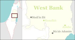
 Mitzpe Yeriho
Website mitzpe.yericho.googlepages.com Mitzpe Yeriho (Hebrew: מִצְפֵּה יְרִיחוֹ, lit. Jericho Lookout) is a communal Israeli settlement in the West Bank. Located 20 km east of Jerusalem and 10 km east of Ma'ale Adummim along Highway 1 in the Judean desert, it falls under the jurisdiction of Mateh Binyamin Regional Council. In 2007 it had a population of 1,700. The international community considers Israeli settlements in the West Bank illegal under international law, but the Israeli government disputes this.[1]
Contents
Geography
The village lies on one of the last cliffs marking the edge of the Judean highlands, and overlooks the Jordan Rift Valley, the Dead Sea, and the ancient city of Jericho whence its name is derived. The climate is dry, with temperatures a few degrees warmer than Jerusalem Temperatures all year round.
History
Originally founded in October 1977 during the Jewish holiday of Sukkot, it was supposed to be located on government lands adjacent to Jericho. Due to the objection of then Defense Minister Ezer Weizman, they were moved to Mishor Adumim. Agriculture Minister Ariel Sharon suggested a few days later that they relocate to a barren hilltop overlooking Jericho, the current location.
The original settlers to the area where a mixed group of both religiously observant and non-observant Jews. They later split up into two groups, and the non-observant members established a new settlement, Vered Yericho, located in the Jordan Valley below Mitzpe Yericho and closer to Jericho. Still, Mitzpe Yeriho is a community of various traditions and observance levels. While the main synagogue follows Ashkenazi traditions, there are also two Sephardi synagogues, a Chabad synagogue, a Yemenite synagogue, a Calebach Minyan and several other small functioning minyanim.
In 1982, the town accepted then 27 year old Yehuda Kroizer as community rabbi. Rabbi Kroizer gives regular classes, both in the town as well as in the Yeshivat HaRaayon HaYehudi, the former yeshiva of Rabbi Meir Kahane.
The Yeshiva Netivot Yoseph was founded in 1990.
In 2009, Mitzpe Yeriho became home to a Jewish Temple School. A full size replica of the Temple is under construction. Descendants of the Levitical Priesthood will learn the sacrificial system.
Over 450 families reside in Mitzpe Yericho as of 2010.
Legal status
Like all Israeli settlements in the Israeli-occupied territories, Mitzpe Yeriho is considered illegal under international law, though Israeli disputes this. The international community considers Israeli settlements to violate the Fourth Geneva Convention's prohibition on the transfer of an occupying power's civilian population into occupied territory. Israel disputes that the Fourth Geneva Convention applies to the Palestinian territories as they had not been legally held by a sovereign state prior to Israel taking control of them.[1] This view has been rejected by the International Court of Justice and the International Committee of the Red Cross.[2]
Economy
The village is home to several businesses including an electronics facility, and also serves tourism in the nearby Wadi Kelt park and its Byzantine-era Saint George Monastery and Hasmonean-era Kypros fortress.[3]
References
- ^ a b "The Geneva Convention". BBC News. 10 December 2009. http://news.bbc.co.uk/2/hi/middle_east/1682640.stm. Retrieved 27 November 2010.
- ^ Legal Consequences of the Construction of a Wall in the Occupied Palestinian Territory International Court of Justice, 9 July 2004. pp. 44-45
- ^ St George's Monastery, Israel PlanetWare.com
External links
Communal
settlementsAlmon (Anatot) · Alon · Ateret · Beit Horon · Dolev · Eli · Geva Binyamin (Adam) · Giv'on HaHadasha · Halamish (Neveh Tzuf) · Hashmonaim · Kfar Adumim · Kfar HaOranim (Menora/Giv'at Ehud) · Kokhav HaShahar · Kokhav Ya'akov · Ma'ale Levona · Ma'ale Mikhmas · Mitzpe Yeriho · Na'ale · Nahliel · Neria (Talmon Bet) · Nili · Nofei Prat · Ofra · Psagot · Rimonim · Shilo · Shvut Rachel · TalmonIndustrial Zones Sha'ar Binyamin Industrial ZoneOutposts Ahia · Adei Ad · Amona, Mateh Binyamin* · Esh Kodesh · Giv'at Asaf · Giv'at Har'el · Harasha · Keeda* · Ma'ale Shlomo · Migron · Mitzpe Dani · Mitzpe Hagit · Mitzpe Kramim · Neveh Erez · Oz-Zion · Yishuv HaDa'at
(*Organised as a communal settlement)Categories:- Mateh Binyamin Regional Council
- Community settlements in Israel
- Populated places established in 1977
- Religious Israeli settlements

Wikimedia Foundation. 2010.