- Poospatuck Reservation, New York
Infobox Settlement
official_name = Poospatuck Reservation, New York
settlement_type = Reservation
nickname =
motto =
imagesize =
image_caption =
image_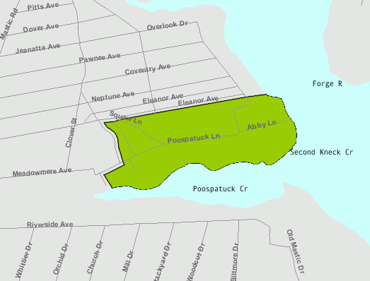
mapsize = 250x200px
map_caption =
pushpin_
mapsize1 =
map_caption1 =subdivision_type = Country
subdivision_name =United States
subdivision_type1 = State
subdivision_name1 =New York
subdivision_type2 = County
subdivision_name2 = Suffolk
government_footnotes =
government_type =
leader_title =
leader_name =
leader_title1 =
leader_name1 =
established_title =
established_date =area_footnotes =
area_magnitude =
area_total_km2 =
area_land_km2 = 0.2927
area_water_km2 = 0.1456
area_total_sq_mi =
area_land_sq_mi =
area_water_sq_mi =population_as_of = 2000
population_footnotes =
population_total = 271
population_density_km2 = 1,162.6
population_density_sq_mi = 3,040.9timezone = Eastern (EST)
utc_offset = -5
timezone_DST = EDT
utc_offset_DST = -4
elevation_footnotes =
elevation_m =
elevation_ft = 17
latd = 40 |latm = 47 |lats = 23 |latNS = N
longd = 72 |longm = 49 |longs = 58 |longEW = Wpostal_code_type =
ZIP code
postal_code = 11950
area_code = 631
blank_name = FIPS code
blank_info =
blank1_name = GNIS feature ID
blank1_info = 979384
website =
footnotes = The Poospatuck Reservation is anIndian reservation in the community of Mastic, Suffolk County,New York ,United States . The population was 271 at the 2000 census.The reservation is the smallest in New York. It is located on the north side of Poospatuck Creek on the east side of Poospatuck Lane and south of Eleanor Avenue.
The reservation is recognized by the
State of New York but not theBureau of Indian Affairs – an important difference in the debate overIndian gaming .Geography
According to the
United States Census Bureau , the Indian reservation has a land area of 0.2927 km² (72.33acre s), and a water area of 0.1456 km² (35.976 acres). The reservation reports the size of the reservation is actually 55 acres. [ [http://www.newsday.com/about/ny-iholi020105story,0,509208.htmlstory Newsday.com] ]Demographics
As of the
census of 2000, there are 271 people, 93 households, and 67 families residing in the Indian reservation. The population density is 1,162.6/km² (3,040.9/mi²). There are 100 housing units at an average density of 429.0 persons/km² (1,122.1 persons/mi²). The racial makeup of the Indian reservation is 1.48% White, 12.92%African American , 79.34% Native American, 0.00%Asia n, 0.00% Pacific Islander, 0.74% from other races, and 5.54% from two or more races. 4.80% of the population areHispanic orLatino of any race.There are 93 households out of which 47.3% have children under the age of 18 living with them, 29.0% are married couples living together, 32.3% have a woman whose husband does not live with her, and 26.9% are non-families. 24.7% of all households are made up of individuals and 2.2% have someone living alone who is 65 years of age or older. The average household size is 2.91 and the average family size is 3.51.
In the Indian reservation the population is spread out with 36.5% under the age of 18, 10.0% from 18 to 24, 30.3% from 25 to 44, 17.3% from 45 to 64, and 5.9% who are 65 years of age or older. The median age is 27 years. For every 100 females there are 78.3 males. For every 100 females age 18 and over, there are 79.2 males.
The median income for a household in the Indian reservation is $13,125, and the median income for a family is $17,500. Males have a median income of $47,500 versus $20,250 for females. The per capita income for the Indian reservation is $8,127. 36.6% of the population and 36.8% of families are below the poverty line. Out of the total people living in poverty, 46.6% are under the age of 18 and 25.0% are 65 or older.
References
* [http://factfinder.census.gov/servlet/DTTable?_bm=y&-context=dt&-ds_name=DEC_2000_SF1_U&-CHECK_SEARCH_RESULTS=N&-CONTEXT=dt&-mt_name=DEC_2000_SF1_U_P001&-mt_name=DEC_2000_SF1_U_P003&-tree_id=4001&-all_geo_types=Y&-redoLog=true&-transpose=N&-_caller=geoselect&-geo_id=25000US9300&-geo_id=27300US9300361031000046074&-geo_id=27300US9300361035910646074&-search_results=25000US9300&-format=&-_lang=en&-show_geoid=Y Poospatuck (state) Reservation, New York] United States Census Bureau

Wikimedia Foundation. 2010.