- Devil's Garden volcanic field
-
Devil's Garden Volcanic Field 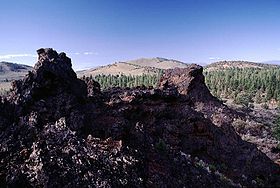
The Blowouts, the spatter vents in the foreground, are the source vents of the voluminous Devils Garden lava field.Elevation 5,571 ft (1,698 m) [1] Location Location Lake County, Oregon, USA Coordinates 43°31′N 120°52′W / 43.52°N 120.86°WCoordinates: 43°31′N 120°52′W / 43.52°N 120.86°W [2] Geology Type volcanic field Age of rock Holocene? [1] Last eruption More than 50,000 years ago [2] Portions of this article include public domain text from the USFS Deschutes & Ochoco National Forests - Crooked River National Grassland.
Devil's Garden Volcanic Field is a volcanic field located south east of Newberry Caldera in Oregon.[1] The lava field consists of several flows of pahoehoe lava that erupted from fissure vents in the northeast part of the Devils Garden. The main vent on the north end of the fissure fed two large gutter/tube systems. Several small vents to the south produced The Blowouts (two large spatter cones), several small spatter cones, and flows. Several older hills and higher areas were completely surrounded by the flows to form kipukas. The distal ends of the flows show excellent examples of inflated lava.[2]
The flows cover an area of 45 square miles (117 km2).[3]
Devil's Garden is most likely between 50,000 and 10,000 years old. It is certainly older than the formation of Crater Lake as ash from the eruption of Mount Mazama overlays the Devil's Garden lava flows.[4]
References
- ^ a b c "Devils Garden". Global Volcanism Program, Smithsonian Institution. http://www.volcano.si.edu/world/volcano.cfm?vnum=1202-12-. Retrieved 2008-05-07.
- ^ a b c "Oregon Volcanoes - Devils Garden Flows". Deschutes & Ochoco National Forests - Crooked River National Grassland. United States Forest Service. 2003-11-26. http://www.fs.fed.us/r6/centraloregon/geology/info/volcanoes/devilsgarden.shtml. Retrieved 2008-05-11.
- ^ "Devils Garden, Oregon". VolcanoWorld. http://volcano.oregonstate.edu/vwdocs/volc_images/north_america/devils_garden.html. Retrieved 2009-01-08.
- ^ Wood, Charles A.; Jűrgen Kienle (1993). Volcanoes of North America. Cambridge University Press. pp. 203. ISBN 0-512-43811-X. http://books.google.com/books?id=eyDRib-FJh4C&pg=PA203&lpg=PA203&dq=Devil%27s+Garden+Volcanic+Field&source=web&ots=O9xvRpXHaq&sig=y8UuPhNoG0emjlCMr3XgrUaTg3k&hl=en&sa=X&oi=book_result&resnum=3&ct=result.
Categories:- Volcanism of Oregon
- Volcanoes of Oregon
- Landforms of Lake County, Oregon
- Volcanic fields of the western United States

Wikimedia Foundation. 2010.