- Evansville Regional Airport
-
Evansville Regional Airport 
IATA: EVV – ICAO: KEVV – FAA LID: EVV Location of the Airport in Indiana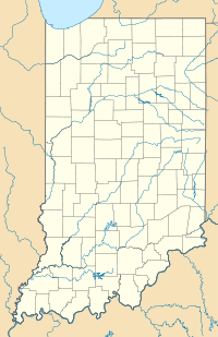
 EVV
EVVSummary Airport type Public Owner Evansvlle/Vanderburgh Airport Authority Location Evansville, Indiana Elevation AMSL 418 ft / 127 m Coordinates 38°02′13″N 087°31′57″W / 38.03694°N 87.5325°W Website Runways Direction Length Surface ft m 4/22 8,021 2,445 Asphalt 9/27 3,500 1,067 Asphalt 18/36 6,286 1,916 Asphalt Source: Federal Aviation Administration[1] Evansville Regional Airport (IATA: EVV, ICAO: KEVV, FAA LID: EVV) is a public airport located three miles (5 km) north of the central business district of Evansville, a city in Vanderburgh County, Indiana, United States. This airport is publicly owned by Evansville/Vanderburgh Airport Authority.[1]
It provides nearly 30 daily flights to and from national hub-airport locations throughout the United States. These airline hubs consist of Atlanta, Chicago, Dallas/Fort Worth, and Detroit.
Contents
History
Established in 1928 on 260 acres (1.1 km²) of land along U.S. Highway 41 and funded by a city bond issue, the original airport construction included a small terminal, weather bureau, hangar, runways, boundary lights, grading, and drainage work.
On June 16, 1930, the Evansville Municipal Airport and its two runways were officially dedicated. Those runways, which were 100 X 1,200 square feet and four inches thick, cost $30,000 to complete. The first Evansville Airport Manager was Werner J. Genot. He took charge on December 16, 1930.[2]
Interstate Airlines made Evansville a stop on their Chicago-Atlanta and St. Louis-Louisville routes on October 19, 1928. Also in 1928, Capital Air Corporation started passenger service through Evansville. From February 1933 to September 1940, the airport did not have a commercial airline. The, Eastern Airlines brought four commercial flights a day to Evansville. This service showed that Evansville’s airport needed to grow. Plans were put in place for expansion.[3]
In 1950, a new airport terminal opened. The construction cost was $787,000. Evansville City Council passed and ordinance to change the name of the airport to Dress Memorial Airport on October 11, 1950, and on October 29, 1950, the new terminal was dedicated. The total airport property now consisted of 467 acre. Only 347 of there acres were utilized for aircraft operations. The remaining 120 acres were used for agriculture.[4]
The first jet that actually landed at the Evansville airport landed in September of 1964. It was a chartered 727 that had Presidential candidate Barry Goldwater on board.
The original terminal was replaced in 1988 with the new William H. Dress Terminal. The new terminal was designed by Hafer Associates[5] and provides 140,000 square feet (13,000 m²) of space and ten carrier gates.[6]
Facilities
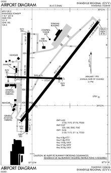
EVV has three runways and is equipped with an Instrument Landing System (ILS), providing precision instrument approaches. The airport encompasses 1,400 acres (5.7 km²) and the passenger terminal provides 140,000 square feet (13,000 m²) of space and ten carrier gates.
Airlines and destinations
Airlines Destinations American Eagle Chicago-O'Hare, Dallas/Fort Worth Delta Connection operated by Atlantic Southeast Airlines Atlanta, Detroit Delta Connection operated by Comair Atlanta Delta Connection operated by Pinnacle Airlines Detroit Accidents
Two aviation accidents have been associated with the area surrounding the airport.
- On December 13, 1977, Douglas C-53 N51071 of National Jet Services crashed on take-off from whilst on a domestic non-scheduled passenger flight to Nashville Metropolitan Airport, Tennessee. All 29 people on board were killed, including the entire University of Evansville basketball team. The cause of the accident was that the gust locks had not been removed and the aircraft was improperly loaded, resulting in an aft CoG.[7]
- On February 6, 1992, a C-130 military transport aircraft operated by the Kentucky Air National Guard, with five crew aboard, crashed at 9:48 A.M. one mile south of the airport in the parking lot of JoJo's restaurant in connection with the Drury Inn on U.S. Highway 41. Sixteen people were killed in the crash and fifteen others were injured. Both JoJo's restaurant and Drury Inn were damaged but were repaired and are still operating just south of the airport although JoJo's is now a Denny's restaurant [8]
See also
References
 This article incorporates public domain material from websites or documents of the Air Force Historical Research Agency.
- ^ a b FAA Airport Master Record for EVV (Form 5010 PDF)
- ^ "EVV History". Evansville Regional Airport. http://www.evvairport.com/About_EVV/evvhistory.html#today. Retrieved 1 September 2011.
- ^ "EVV History". Evansville Regional Airport. http://www.evvairport.com/About_EVV/evvhistory.html#today. Retrieved 1 September 2011.
- ^ "EVV History". Evansville Regional Airport. http://www.evvairport.com/About_EVV/evvhistory.html#today. Retrieved 1 September 2011.
- ^ "Civic Projects by Hafer Associates". Hafer Associates. http://www.haferassociates.com/airport.php. Retrieved 2007-09-04.
- ^ "Evansville Regional Airport Fact Sheet". Evansville Regional Airport. Archived from the original on 2006-11-10. http://web.archive.org/web/20061110055809/http://www.evvairport.com/facts/. Retrieved 2007-01-06.
- ^ "N51071 Accident description". Aviation Safety Network. http://aviation-safety.net/database/record.php?id=19771213-0. Retrieved 5 August 2010.
- ^ "Indiana plane crashes". Indianapolis Star. 2002-05-01. http://www2.indystar.com/library/factfiles/history/disasters/planecrashes.html. Retrieved 2008-06-06.
External links
- Evansville Regional Airport (official site)
- Aerial photo from Indiana Department of Transportation
- FAA Airport Diagram (PDF), effective 20 October 2011
Coordinates: 38°02′13″N 087°31′57″W / 38.03694°N 87.5325°W
- Resources for this airport:
- AirNav airport information for KEVV
- ASN accident history for EVV
- FlightAware airport information and live flight tracker
- NOAA/NWS latest weather observations
- SkyVector aeronautical chart for KEVV
- FAA current EVV delay information
Airports in Indiana Primary Evansville Regional Airport · Fort Wayne International Airport · Indianapolis International Airport · South Bend Regional Airport
Relief General Anderson Municipal Airport · Arens Field · Columbus Municipal Airport · Crawfordsville Municipal Airport · DeKalb County Airport · Delaware County Airport · Delphi Municipal Airport · Elkhart Municipal Airport · Frankfort Municipal Airport · Freeman Municipal Airport · French Lick Municipal Airport · Fulton County Airport · Gary/Chicago International Airport · Goshen Municipal Airport · Greensburg-Decatur County Airport · Greenwood Municipal Airport · Virgil I. Grissom Municipal Airport · Huntingburg Airport · Huntington Municipal Airport · Indianapolis Downtown Heliport · Jasper County Airport · Kendallville Municipal Airport · Kentland Municipal Airport · Kokomo Municipal Airport · La Porte Municipal Airport · Logansport/Cass County Airport · Madison Municipal Airport · Marion Municipal Airport · Mettel Field · Michigan City Municipal Airport · Monroe County Airport · New Castle-Henry County Municipal Airport · North Vernon Airport · Paoli Municipal Airport · Perry County Municipal Airport · Peru Municipal Airport · Plymouth Municipal Airport · Porter County Regional Airport · Portland Municipal Airport · Purdue University Airport · Putnam County Airport · Randolph County Airport · Richmond Municipal Airport · Salem Municipal Airport · Shelbyville Municipal Airport · Sheridan Airport · Smith Field · Starke County Airport · Tri-State Steuben County Airport · Sullivan County Airport · Terre Haute International Airport · Wabash Municipal Airport · Warsaw Municipal Airport · White County Airport
City of Evansville Annual Festivals Evansville Freedom Festival • Germania Männerchor Volksfest • West Side Nut Club Fall Festival • Vanderburgh County 4H Fair • Frog Follies • ShirnersFestArenas and Venues Bosse Field • The Centre • Ford Center • Goebel Soccer Complex • Mesker Amphitheatre • Roberts Municipal Stadium • Swonder Ice Arena • Metro Sports Center • Victory Theatre • Veterans Memorial ColiseumCorporate Headquarters
and Major EmployersAccuride • Alcoa • AK Steel • Atlas Van Lines • Berry Plastics • Bristol Myers Squibb • Mead Johnson • Old National Bank • SABIC Innovative Plastics • Shoe Carnival • Springleaf Financial • TJ Maxx • Toyota • VectrenEducation Evansville Vanderburgh School Corporation • Roman Catholic Diocese of Evansville • Evansville-Vanderburgh Public Library • Ivy Tech Community College • University of Evansville • University of Southern Indiana • ITT Technical Institute • Harrison College • Oakland City UniversityNeighborhoods / Districts Downtown • Haynies Corner • Jacobsville • Riverside Historic District • Washington Avenue Historic DistrictAttractions Malls & Other Commerce Sports Evansville Purple Aces • USI Screaming Eagles • Evansville Otters • Evansville IceMen • Evansville Enforcers • Demolition City Roller Derby • Evansville Crush • Southern Indiana Athletic Conference • Refrigerator Bowl • Hoosier Nationals • Thunder on the Ohio • Rollergirls of Southern IndianaTransportation Evansville Regional Airport • Metropolitan Evansville Transit System • Interstate 64 • Interstate 164 • Interstate 69 • U.S. Route 41 • Lloyd Expressway • State Road 57 • State Road 62 • State Road 65 • State Road 66 • State Road 662 • University Parkway • Veterans Memorial ParkwayHealthcare & Emergency Deaconess Hospital • Deaconess Gateway and Women's Hospital • St. Mary's Hospital and Medical Center • Southwestern Indiana Mental Health System • The Welborn SystemRegional Categories:- Airfields of the United States Army Air Forces Technical Service Command
- Buildings and structures in Evansville, Indiana
- Airports in Indiana
- Airfields of the United States Army Air Forces in Indiana
- Transportation in Vanderburgh County, Indiana


Wikimedia Foundation. 2010.