- Crowheart, Wyoming
-
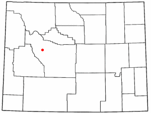
Crowheart, Wyoming — CDP — Location of Crowheart, Wyoming
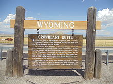
Coordinates: 43°20′1″N 109°14′19″W / 43.33361°N 109.23861°WCoordinates: 43°20′1″N 109°14′19″W / 43.33361°N 109.23861°W Country United States State Wyoming County Fremont Area – Total 31.3 sq mi (81.0 km2) – Land 31.3 sq mi (81.0 km2) – Water 0.0 sq mi (0.0 km2) Elevation 6,096 ft (1,858 m) Population (2000) – Total 163 – Density 5.2/sq mi (2.0/km2) Time zone Mountain (MST) (UTC-7) – Summer (DST) MDT (UTC-6) ZIP code 82512 Area code(s) 307 FIPS code 56-18225[1] GNIS feature ID 1597273[2] Crowheart is a census-designated place (CDP) in Fremont County, Wyoming, United States. The population was 163 at the 2000 census. Nearby Crowheart Butte was the site of a battle between the Crow and Shoshone American Indian tribes in 1866. According to legend, following a five day battle for rights to the hunting grounds in the Wind River Range, Chief Washakie of the Shoshone and Chief Big Robber of the Crow agreed to a duel, with the winner gaining the rights to the Wind River hunting grounds. Chief Washakie eventually prevailed, but he was so impressed with the courage of his opponent, that rather than scalp him, he instead cut out his heart and placed it on the end of his lance.
Contents
Demographics
As of the census[1] of 2000, there are 163 people, 62 households, and 43 families residing in the CDP. The population density is 5.2 people per square mile (2.0/km²). There are 80 housing units at an average density of 2.6/sq mi (1.0/km²). The racial makeup of the CDP is 49.08% White, 43.56% Native American, 1.23% from other races, and 6.13% from two or more races. 3.07% of the population are Hispanic or Latino of any race.
There are 62 households out of which 37.1% have children under the age of 18 living with them, 45.2% are married couples living together, 16.1% have a female householder with no husband present, and 30.6% are non-families. 27.4% of all households are made up of individuals and 8.1% have someone living alone who is 65 years of age or older. The average household size is 2.63 and the average family size is 3.23.
In the CDP the population is spread out with 32.5% under the age of 18, 6.7% from 18 to 24, 23.9% from 25 to 44, 27.0% from 45 to 64, and 9.8% who are 65 years of age or older. The median age is 36 years. For every 100 females there are 147.0 males. For every 100 females age 18 and over, there are 120.0 males.
The median income for a household in the CDP is $35,500, and the median income for a family is $35,750. Males have a median income of $31,111 versus $30,313 for females. The per capita income for the CDP is $18,434. 14.0% of the population and 17.8% of families are below the poverty line. Out of the total population, 8.2% of those under the age of 18 and 52.2% of those 65 and older are living below the poverty line.
Education
Public education in the community of Crowheart is provided by Fremont County School District #6. Zoned campuses include Crowheart Elementary School (grades K-3) and Wind River Middle/High School (grades 6-12).
Notable people from Crowheart
- Matthew Fox — Plays Jack Shephard in Lost and was also a main character in Party of Five.
References
- ^ a b "American FactFinder". United States Census Bureau. http://factfinder.census.gov. Retrieved 2008-01-31.
- ^ "US Board on Geographic Names". United States Geological Survey. 2007-10-25. http://geonames.usgs.gov. Retrieved 2008-01-31.
Municipalities and communities of Fremont County, Wyoming Cities 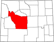
Towns CDPs Arapahoe | Atlantic City | Boulder Flats | Crowheart | Ethete | Fort Washakie | Jeffrey City | Johnstown
Unincorporated
communitiesKinnear | Kotey Place | Lysite | Miner's Delight | St. Stephens | South Pass City
Ghost town Indian reservation Categories:- Populated places in Fremont County, Wyoming
- Census-designated places in Wyoming


Wikimedia Foundation. 2010.