- Miner's Delight, Wyoming
-
Hamilton City
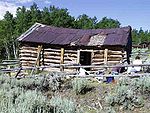
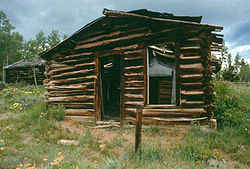 An abandoned cabin in the ghost town at Miner's Delight
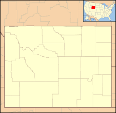

Location: Fremont County, Wyoming, NE of Atlantic City Nearest city: Atlantic City, Wyoming Coordinates: 42°31′58″N 108°40′48″W / 42.53278°N 108.68°WCoordinates: 42°31′58″N 108°40′48″W / 42.53278°N 108.68°W Governing body: Bureau of Land Management NRHP Reference#: 80004047 Added to NRHP: June 4, 1980 Hamilton City, or Miner's Delight as it was commonly known, was a town in Fremont County, Wyoming, United States, during the mining boom in the 19th century. Today a few buildings stand as a reminder of an era gone past in Wyoming history.
Contents
Demographics
Miner's Delight went through boom-bust periods, like many of the western mining towns did. The original mining activity "busted" from 1872 to 1874 but by the 1880s a new era of economic prosperity had dawned. Smaller booms occurred in 1907 and 1910 and then again during the Great Depression.[1] The town was inhabited as late as 1960. In 1870, at the height of the mine's operation the population in Hamilton City was 75, 40 of which were miners.[2]
History
 The Bureau of Land Management has worked toward the preservation of the ruins of Miner's Delight.
Miner's Delight was among the state of Wyoming's first communities. Gold was discovered there in 1868 and with that discovery came an era of gold mining and the establishment of the town of Hamilton City. The Miner's Delight mine was located about a quarter mile west of the town. Boom and bust periods followed the operation of the mine. In March 1882 the mine was completely shut down and not used again until after the turn of the 20th century. The two brief boom periods, 1907 and 1910, were in relation to mining operations.
Today, through historic preservation by the Bureau of Land Management and various university programs and courses, the ghost town at Miner's Delight stands as a testament to the passage of time and provides historians with a peek at early Wyoming life and the gold mining culture. On the townsite are seventeen structures including seven cabins, one saloon, one meat house, one shop or barn, one shaft house, one pantry, one cellar, three privies, and a corral. All of the buildings are constructed of logs or unfinished lumber.[1]
Miner's Delight was added to the National Register of Historic Places on June 4, 1980.
Name history
The town's nomenclature and how it ended up being called Miner's Delight over Hamilton City is a topic of historical debate. There are generally two stories associated with the changing of the town's name. Both stories involve the discovery of a golden lode, a miner's delight, on the ridge above town.
The first story goes, in 1869 a man named William Jones, while chasing his cows about pasture, stumbled across some quartz with gold flecks dotting it. The site was so remote and so far above town that he erroneously assumed no one else would ever find it. Contented, he continued on his way, gathering his stray cattle. When he returned to the site of the gold lode he found others working the claim. He tried to relate his tale of the discovery to the other miners but they would have none of it and they ran him off.
The other story does not have quite the same Old West flair as the tale of Jones' would-be discovery. A man named Johnathan Pugh, who incidentally is listed as one of the original founders of the lode, claimed to have discovered the gold. He even described the quartz ridge above town, down to the gold nuggets embedded in it.[3]
References
- ^ a b Landers Field Office: Bureau of Land Management
- ^ Miner's Delight: Wyoming State Parks and Cultural Resources
- ^ Capron, Ranel. Mysterious Discovery. Bureau of Land Management
External links
- Miner's Delight on Ghosttowns.com
- Landers Field Office: Bureau of Land Management
- [1]: Wyoming State Parks and Cultural Resources
Municipalities and communities of Fremont County, Wyoming Cities 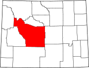
Towns CDPs Arapahoe | Atlantic City | Boulder Flats | Crowheart | Ethete | Fort Washakie | Jeffrey City | Johnstown
Unincorporated
communitiesKinnear | Kotey Place | Lysite | Miner's Delight | St. Stephens | South Pass City
Ghost town Miner's Delight
Indian reservation Categories:- Historic districts in Wyoming
- National Register of Historic Places in Wyoming
- Ghost towns in Wyoming
- Protected areas of Fremont County, Wyoming
- Bureau of Land Management areas in Wyoming
- Buildings and structures in Fremont County, Wyoming


Wikimedia Foundation. 2010.