- Cissbury Ring
-
Cissbury Ring is a hill fort on the South Downs, in the borough of Worthing, and about 5 kilometres (3 mi) from its town centre, in the English county of West Sussex.

Contents
Hill fort
It is the largest hill fort in Sussex, the second largest in England[1] and one of the largest in Britain and Europe overall, covering some 60 acres (24 hectares).[2] The earthworks that form the fortifications were built around the beginning of the Middle Iron-Age possibly around 250 BC[3] but abandoned in the period 50 BC - 50 AD.
Flint mines
Long before the hill was fortified, flint mines were being excavated in the area. Some shafts went down as far as 40 feet (12 m). The shafts at Cissbury were excavated with antler picks, much like those at Grimes Graves and elsewhere. Flint was the common material for making stone axes for felling timber and working wood during the neolithic period.
Structure
The ditches and banks are the remains of a defensive wall that enclosed 65 acres (260,000 m2) of land; the inner band of the wall is over a mile around. The ditches are said to be as deep as three metres and were filled with loosened chalk and covered with timber palisade. The 600 foot (184 m) hill is open to the public. From the top, one is able to see to the west Selsey, Chichester Cathedral, the Spinnaker Tower and the Isle of Wight. To the east, one is able to see Brighton, the Seven Sisters and Beachy Head. Cissbury Ring is the highest point in the borough of Worthing.
Bronze age
Several Bronze Age barrows have been found just outside Cissbury Ring.
Romano-British period
In this period, Romano-British farmers settled within the ramparts of the hill fort.[3]
Medieval mint
It has been suggested that a medieval mint which produced coinage existed at Cissbury around the eleventh century. Coins have been found across Sussex from Chichester to Lewes bearing the name Sithe, Sithsteb and Sithmes, taken to mean the former name of Cissbury in use at this time of 'Sith(m)esteburh'. The coins found are from the reigns of Ethelred the Unready and Cnut.[4] Although it is quite possible that a mint existed at Cissbury, no trace of it has yet been found.[3]
Later history
In 1867–8 Augustus Lane-Fox excavated part of Cissbury Ring.[5]
During World War II, Cissbury Ring was used as a camp for the 2nd Argyll and Sutherland Highlanders in preparation for the Normandy landings. At this time much of the fort within the ramparts was ploughed to provide food. While on manoeuvres, tanks destroyed the dew pond at the north side of the fort.[6] A gap was made in the ramparts to accommodate a 100 lb (45 kg) gun which was used to fire at ships in the English Channel[1] and an anti-aircraft gun was sited by the gap.[1]
In 1953–1956 Cissbury and its flint mines was excavated by a team led by John Pull.
The ring has many ghostly legends surrounding it and has been a haunt for ghost hunters over the years.
Artefacts from Cissbury Ring can be found at Worthing Museum and Art Gallery, the Museum of Sussex Archaeology, Lewes and the Ashmolean Museum, Oxford.[7] Silver pennies from the reign of Ethelred II (978-1016) can be found at the British Museum.[8]
Conservation area
Cissbury Ring Site of Special Scientific Interest 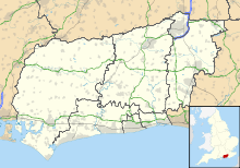
 Shown within West Sussex
Area of Search West Sussex Grid reference TQ140080 Coordinates 50°51′37″N 0°22′46″W / 50.860141°N 0.37932°WCoordinates: 50°51′37″N 0°22′46″W / 50.860141°N 0.37932°W Interest Biological Area 81.9 ha (202 acres) Notification 1980 Natural England website Cissbury Ring is owned by the National Trust and is a legally-protected Scheduled Ancient Monument. It also lies within the area of the proposed South Downs National Park.
The site has been given the status of Site of Special Scientific Interest due to its nationally rare unimproved chalk grassland.
Etymology
Once taken to mean Caesar's fort (after Julius Caesar) or Cissa's fort (after South Saxon king Ælle's son, Cissa), both theories of Cissbury's meaning have been discounted.[9] In the early eleventh century in the reign of Ethelred the Unready, Cissbury was known as 'Sith(m)esteburh', which is taken to mean the 'last or the latest fort'. This may mean that Cissbury was the last fort to be refortified, after another nearby fort such as that at Burpham.[9] It seems that the name Cissbury was altered to accommodate the legend that the fort was linked to Cissa the South Saxon.
Folklore
Cissbury Ring was said to have been formed when the Devil tried to dig a hole in the South Downs, to allow the sea to flood the Sussex Weald and all its churches. As the devil dug out Devil's Dyke, clods of earth fell to the ground forming Cissbury, Chanctonbury, Rackham Hill and Mount Caburn.[4]
Under Threat
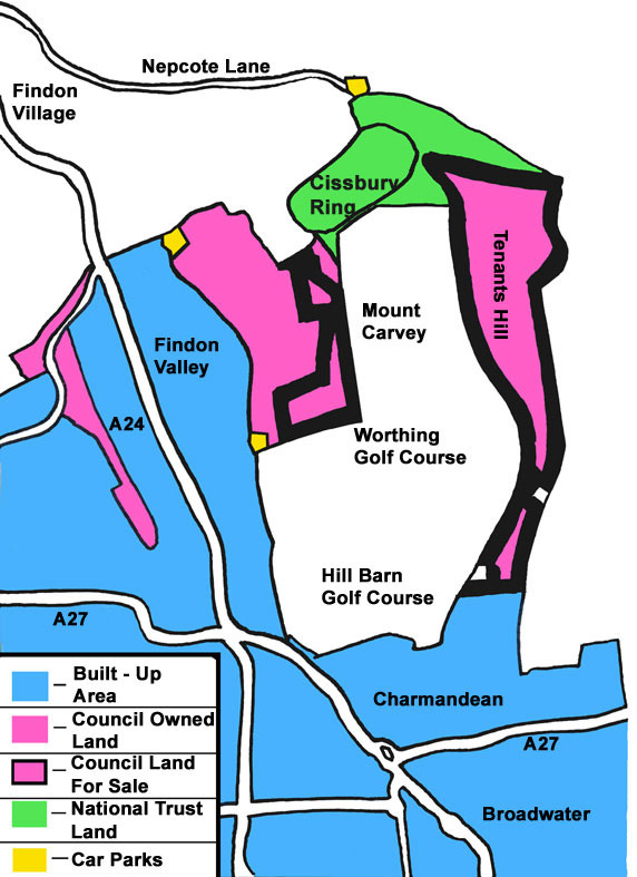
Worthing Council is selling off 57 acres (230,000 m2) of downland at Cissbury Ring – a decision which has sparked fears of future development on the south-east and south-west flanks of the ancient hill fort.
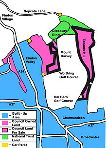 Land to be sold by Worthing Council at Cissbury Ring
See also
References
- ^ a b c http://www.nationaltrust.org.uk/main/w-global/w-localtoyou/w-south_east/w-south_east-countryside/w-south_east-places-west_sussex/w-south_east-places-west_sussex-cissbury.htm
- ^ http://links.jstor.org/sici?sici=0002-7294(190507%2F09)2%3A7%3A3%3C529%3ANDAC%3E2.0.CO%3B2-L
- ^ a b c http://www.visitworthing.co.uk/AboutWorthing/HistoricalCountrysideFeatures/
- ^ a b http://www2.prestel.co.uk/aspen/sussex/cissbury.html
- ^ Thompson, M. W. (1977). General Pitt-Rivers: evolution and archaeology in the nineteenth century. Bradford-on-Avon: Moonraker Press. p. 48. ISBN 0-239-00162-1.
- ^ http://www.findonvillage.com/0680_dewpond_on_the_north_side_of_cissbury_ring.htm
- ^ http://www.bournemouth.ac.uk/caah/landscapeandtownscapearchaeology/neolithic_flint_mines_of_sussex.html
- ^ http://www.britishmuseum.org/explore/highlights/highlight_objects/cm/s/silver_pennies_of_ethelred_ii.aspx
- ^ a b http://www.findon.info/names/names.htm
External links
Categories:- Hill forts in West Sussex
- History of West Sussex
- Sites of Special Scientific Interest in West Sussex
- Sites of Special Scientific Interest notified in 1980
- Visitor attractions in West Sussex
- Worthing
- Hills of West Sussex


Wikimedia Foundation. 2010.