- Cissbury
-
Cissbury Neolithic flint mine and Iron Age hillfort Country England Region South East England District Worthing Elevation 184 m (604 ft) Style Neolithic Founded Around 3000 BC Owner Managed by National Trust Visitation Located north of Worthing off A24 Website: http://www.nationaltrust.org.uk/main/w-global/w-localtoyou/w-south_east/w-south_east-countryside/w-south_east-places-west_sussex/w-south_east-places-west_sussex-cissbury.htm Cissbury is the name of a prehistoric site near the village of Findon around 5 miles north of Worthing in the English county of West Sussex. The site is managed by the National Trust.
 Plan of Cissbury fort showing shafts
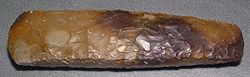
The site was one of the first Neolithic flint mines in Britain and it was exploited throughout the period. (the nearby Harrow Hill series of flint mines is slightly older). It is part of a group of flint mines in Sussex which followed a rich seam of flint bearing chalk. Other examples include Grimes Graves in Suffolk, and Harrow Hill nearby. Cissbury was one of several important mining industries in the UK during the Neolithic and is thought to have been used into the Bronze age, and later the Iron Age though flint mining probably stopped during the late neolithic, but there is some evidence of re-use of flint for tools during later times. Examples of Cissbury flint can be found as far as Italy. Many other types of stone were in demand for stone axes such as the greenstone of the Langdale axe industry in the Lake District. The axes were essential for forest clearance for farming in the Neolithic period, and found many other uses, such as wood working.
Around 200 shafts were dug into the Cissbury hill over around 900 years of use. Shafts were up to 12 m deep with 7 m diameters at the surface. Up to eight galleries extended outwards from the bottoms of the shafts, often interconnecting with one another.
Contents
Excavation
Excavation of the mine shafts by John Pull in the 1950s uncovered the remains of a young woman who had been apparently killed in a tunnel collapse around 2000 BC. Charcoal possibly from her torch and a miniature whale carved from chalk were with her. The possibility that the shaft was used for a ritual burial has also been suggested however. The remains of two other people, a man and a woman, were recovered from different shafts at Cissbury in the nineteenth century and it has been suggested that the exhausted mines had a secondary purpose for formal burial. Alternatively, it may have been expedient to send women into the mines as they could squeeze into the narrow galleries and some archaeologists have suggested that flint extraction was a rite of passage for the more slightly-built juvenile members of Neolithic societies.
The site is significant as it represents the switch from open cast flint extraction favoured previously by prehistoric peoples who exploited deposits of flint close to the surface, to deep shaft mining which required more effort but produced more flint of a higher quality.
Hill fort
Cissbury Ring is the name of a later Iron Age hill fort that occupied the site between 300BC and the Roman conquest, a Roman mint is thought to have also occupied the site.
See also
Bibliography
- Russell, Miles, Rough quarries, rocks and hills : John Pull and the neolithic flint mines of Sussex. Oxford: Oxbow, (2001). (Bournemouth University School of Conservation sciences occasional series.)
- Russell, Miles, Flint Mines in Neolithic Britain. Tempus. Stroud, (2000).
- Russell, Miles The Early Neolithic Architecture of the South Downs. British Archaeological Report 321, (2001). Archaeopress. Oxford.
- Russell, Miles Prehistoric Sussex. Tempus. Stroud, (2002).
- Russell, Miles Monuments of the British Neolithic: The Roots of Architecture. Tempus. Stroud, (2002).
External links
Categories:- Bronze Age sites in England
- Buildings and structures in West Sussex
- History of West Sussex
- Iron Age sites in England
- Stone Age sites in England
- Worthing
- Archaeological sites in West Sussex
- Prehistoric mines


Wikimedia Foundation. 2010.