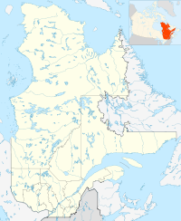
- Clermont, Capitale-Nationale, Quebec
-
Clermont — City — 
Coat of armsCoordinates: 47°41′N 70°14′W / 47.683°N 70.233°W Country  Canada
Province  Quebec
Region Capitale-Nationale Regional county Charlevoix-Est Settled 1800 Incorporated February 16, 1935 Government[1] - Mayor Jean-Pierre Gagnon - Federal riding Montmorency—Charlevoix—Haute-Côte-Nord - Prov. riding Charlevoix Area[1][2] - Total 52.99 km2 (20.5 sq mi) - Land 49.59 km2 (19.1 sq mi) Population (2006)[2] - Total 3,041 - Density 61.3/km2 (158.8/sq mi) Time zone EST (UTC-5) - Summer (DST) EDT (UTC-4) Postal Code G4A Area code(s) 418 and 581 Website www.ville.clermont.qc.ca Clermont is a ville in the Canadian province of Quebec, and the seat of government for the Charlevoix-Est Regional County Municipality. It is located on the southern banks of the Malbaie River.
Contents
History
Around 1800, the first settlers moved into the area, living primarily of agriculture. Followed by a saw and flour mill, tradeshops, and stores, a settlement grew that was then known as Chute Nairne. At the close of the century, the place attracted attention for its hydro-electric potential, and by 1900, a dam was built across the Malbaie River, supplying electricity to La Malbaie and surrounding area.[3]
In 1909, Rodolphe Forget founded the East Canada Power and Pulp Company, and wanting to profit from the phenomenal growth in the pulp and paper market, he built Chute Nairne's first paper mill in 1911. The industrial development changed the place from a rural and agricultural society to a rapidly growing urban community.[3]
Félix-Antoine Savard, famous Quebecois author and at that time priest of the Parish of Saint-Étienne in La Malbaie, was also responsible for Chute Nairne. His parishioners there were upset about being left a bit to themselves and about being far away from the parish church. Savard, at the request of residents of Chute Nairne, petitioned the bishop of Chicoutimi, Charles Lamarche, to obtain permission for a new parish and church. The request was accepted on September 18, 1931, and the Parish of Saint-Philippe-de-la-Chute-Nairn was formed.[3]
On February 16, 1935, the place separated from La Malbaie and was incorporated as a municipality, officially adopting the name Clermont for the new municipality. Félix-Antoine Savard greatly admired and paid tribute to Blaise Pascal who came from Clermont-Ferrand in France.[3][4]
In 1949, Clermont changed its status to village and in 1967 to town.[4]
Economy
Clermont's economy centres on the Abitibi-Bowater paper mill, formerly the Donohue mill that was originally founded in 1936 by the brothers Timothy and Charles Donohue and employed close to a thousand people in the 1970s..[3]
Clermont is also the end of the Charlevoix Railway and therefore is an intermodal freight transport hub primarily for wood.
Demographics
Population trend:[5]
- Population in 2006: 3041 (2001 to 2006 population change: -1.2 %)
- Population in 2001: 3078
- Population in 1996: 3225
- Population in 1991: 3385
Private dwellings occupied by usual residents: 1309 (total dwellings: 1356)
Mother tongue:
- English as first language: 0.3 %
- French as first language: 99.4 %
- English and French as first language: 0.3 %
- Other as first language: 0 %
References
- ^ a b Ministère des Affaires Municipales, Régions et Occupation du territoire - Répertoire des municipalités: Clermont
- ^ a b Statistics Canada 2006 Census - Clermont community profile
- ^ a b c d e "Informations municipales >> Historique de la ville" (in French). Ville de Clermont. http://www.ville.clermont.qc.ca/historique. Retrieved 2010-05-21.
- ^ a b "Clermont (Ville)" (in French). Commission de toponymie du Québec. http://www.toponymie.gouv.qc.ca/CT/toposweb/fiche.aspx?no_seq=14104. Retrieved 2010-05-21.
- ^ Statistics Canada: 1996, 2001, 2006 census

Mont-Élie 
Saint-Aimé-des-Lacs 
La Malbaie  Clermont

La Malbaie  Administrative divisions of Capitale-Nationale (Region 03)
Regional county municipalities
and equivalent territoriesMunicipalities Baie-Saint-Paul · Boischatel · Clermont · Donnacona · L'Ancienne-Lorette · La Malbaie · Lac-Beauport · Pont-Rouge · Quebec City · Saint-Augustin-de-Desmaures · Sainte-Catherine-de-la-Jacques-Cartier · Saint-Raymond · Stoneham-et-Tewkesbury
Administrative divisions of Quebec Coordinates: 47°41′00″N 70°14′00″W / 47.683338°N 70.233338°W
Categories:- Cities and towns in Quebec
- Incorporated places in Capitale-Nationale
Wikimedia Foundation. 2010.


